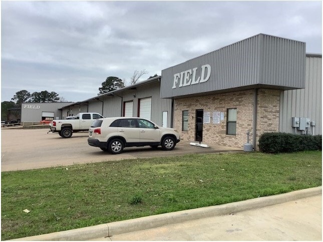
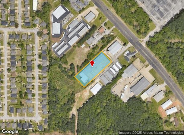
Property Record
13178 State Highway 110 S, Tyler, TX 75707

NEARBY LISTINGS FOR SALE OR LEASE
Property Detail
13178 State Highway 110 S
1-00000-0327-00-012080
A0327 C Dean
Warehouse
ABST A0327 C DEANTRACT 12 H
X
Smith
48423C0370D
Texas
2024
1.56 AC
2025
Tyler & Longview
001807
Other Market Areas
23,750 SF
Tyler, TX
DEMOGRAPHICS near 13178 State Highway 110 S
1 Mile
3 Mile
5 Mile
2024 Total Population
4,253
36,666
91,520
2029 Population
4,605
39,910
99,475
Pop Growth 2024-2029
+ 8.28%
+ 8.85%
+ 8.69%
Average Age
40
39
39
2024 Total Households
1,599
14,982
37,208
HH Growth 2024-2029
+ 7.75%
+ 8.37%
+ 8.16%
Median Household Inc
$62,611
$68,462
$65,857
Avg Household Size
2.50
2.30
2.30
2024 Avg HH Vehicles
2.00
2.00
2.00
Median Home Value
$215,000
$212,907
$214,260
Median Year Built
1996
1984
1983
Nearby Places
Map Layers
Map Styles
 Street
 Aerial
- Restaurants
- Banks
- Shops
- Fitness
- Groceries
PUBLIC TRANSPORTATION
AIRPORT
Tyler Pounds Regional
DRIVE
WALK
Distance
Tyler Pounds Regional
24 min
14.6 mi
Freight Ports
Port of Shreveport
DRIVE
WALK
Distance
Port of Shreveport
126 min
110.6 mi
SALE & LEASE HISTORY
LISTING DATE
SALE/LEASE

Jan 29, 2024
For Lease
Jan 29, 2024
For Sale
Apr 23, 2020
For Lease
Apr 23, 2020
For Sale
Nearby Properties
Address
Land Use
TOTAL SIZE
Lot Size
Zoning
Address
Land Use
TOTAL SIZE
Lot Size
Zoning
22,500 SF
214.44 AC
R1A
Address
Land Use
TOTAL SIZE
Lot Size
Zoning
33,409 SF
151.32 AC
M2
Address
Land Use
TOTAL SIZE
Lot Size
Zoning
18.37 AC
R1A
Address
Land Use
TOTAL SIZE
Lot Size
Zoning
403,396 SF
45.40 AC
C4
Address
Land Use
TOTAL SIZE
Lot Size
Zoning
49,544 SF
28.64 AC
Address
Land Use
TOTAL SIZE
Lot Size
Zoning
84,400 SF
13.98 AC
Address
Land Use
TOTAL SIZE
Lot Size
Zoning
3,052 SF
9.20 AC
PMF
Address
Land Use
TOTAL SIZE
Lot Size
Zoning
43,165 SF
7.33 AC
Address
Land Use
TOTAL SIZE
Lot Size
Zoning
3,189 SF
11.17 AC
RMF
Address
Land Use
TOTAL SIZE
Lot Size
Zoning
66.86 AC
R1A
Address
Land Use
TOTAL SIZE
Lot Size
Zoning
38,900 SF
20.11 AC
INT
Address
Land Use
TOTAL SIZE
Lot Size
Zoning
75,999 SF
5.09 AC
Address
Land Use
TOTAL SIZE
Lot Size
Zoning
37,536 SF
16.81 AC
RMF
Address
Land Use
TOTAL SIZE
Lot Size
Zoning
8,279 SF
14.06 AC
RMF
Address
Land Use
TOTAL SIZE
Lot Size
Zoning
88,964 SF
11.33 AC
Address
Land Use
TOTAL SIZE
Lot Size
Zoning
2,676 SF
8.28 AC
RMF
Address
Land Use
TOTAL SIZE
Lot Size
Zoning
14,752 SF
9.64 AC
RMF
Address
Land Use
TOTAL SIZE
Lot Size
Zoning
52,557 SF
11.44 AC
RMF
Address
Land Use
TOTAL SIZE
Lot Size
Zoning
2,298 SF
9.08 AC
RMF
Address
Land Use
TOTAL SIZE
Lot Size
Zoning
2,987 SF
6 AC
RMF
Address
Land Use
TOTAL SIZE
Lot Size
Zoning
2,499 SF
7.77 AC
RMF
Address
Land Use
TOTAL SIZE
Lot Size
Zoning
105,407 SF
6.14 AC
C4
Address
Land Use
TOTAL SIZE
Lot Size
Zoning
39,468 SF
7.99 AC
RMF
Address
Land Use
TOTAL SIZE
Lot Size
Zoning
1,664 SF
7.52 AC
RMF
Address
Land Use
TOTAL SIZE
Lot Size
Zoning
39,565 SF
9.01 AC
Address
Land Use
TOTAL SIZE
Lot Size
Zoning
93,250 SF
7.92 AC
RMF
Address
Land Use
TOTAL SIZE
Lot Size
Zoning
8,390 SF
12.79 AC
RMF
Address
Land Use
TOTAL SIZE
Lot Size
Zoning
76,216 SF
14.70 AC
PMF
Address
Land Use
TOTAL SIZE
Lot Size
Zoning
27,520 SF
5.91 AC
RMF
Address
Land Use
TOTAL SIZE
Lot Size
Zoning
37,254 SF
9.52 AC
C1
The World's #1 Commercial Real Estate Marketplace
Connect with us
© 2025 CoStar Group
The information above has been obtained from sources believed reliable. While we do not doubt its accuracy we have not verified it and make no guarantee, warranty or representation about it. It is your responsibility to independently confirm its accuracy and completeness. Any projections, opinions, assumptions, or estimates used are for example only and do not represent the current or future performance of the property. The value of this transaction to you depends on tax and other factors which should be evaluated by your tax, financial, and legal advisors. You and your advisors should conduct a careful, independent investigation of the property to determine to your satisfaction the suitability of the property for your needs.