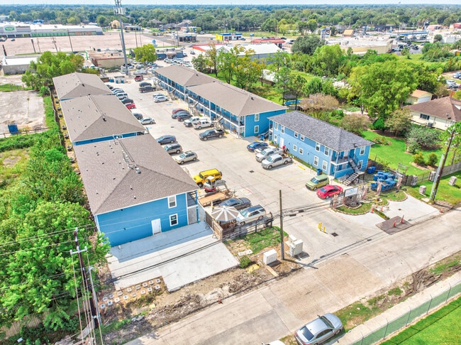
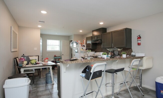
Property Record
1318 Avenue A, South Houston, TX 77587

NEARBY LISTINGS FOR SALE OR LEASE
Property Detail
1318 Avenue A
0341930000205
South Houston Gardens Sec 1
Apartment
TR 118D SOUTH HOUSTON GARDENS SEC 1
AE
Harris
48201C0915N
Texas
2024
1.29 AC
2025
Mount Vernon
321500
Houston
38,930 SF
Houston-Pasadena-The Woodlands, TX
DEMOGRAPHICS near 1318 Avenue A
1 Mile
3 Mile
5 Mile
2024 Total Population
20,646
161,670
310,424
2029 Population
21,232
165,204
317,283
Pop Growth 2024-2029
+ 2.84%
+ 2.19%
+ 2.21%
Average Age
34
35
35
2024 Total Households
6,298
51,718
101,383
HH Growth 2024-2029
+ 2.83%
+ 2.19%
+ 2.22%
Median Household Inc
$47,722
$48,749
$53,194
Avg Household Size
3.20
3.00
3.00
2024 Avg HH Vehicles
2.00
2.00
2.00
Median Home Value
$162,819
$146,561
$158,586
Median Year Built
1969
1971
1974
Nearby Places
Map Layers
Map Styles
 Street
 Aerial
- Restaurants
- Banks
- Shops
- Fitness
- Groceries
PUBLIC TRANSPORTATION
AIRPORT
William P Hobby
DRIVE
WALK
Distance
William P Hobby
16 min
6.7 mi
George Bush Intcntl/Houston
DRIVE
WALK
Distance
George Bush Intcntl/Houston
41 min
29.4 mi
Freight Ports
Port of Houston
DRIVE
WALK
Distance
Port of Houston
16 min
7.8 mi
SALE & LEASE HISTORY
LISTING DATE
SALE/LEASE

Oct 27, 2021
For Sale
May 16, 2023
For Sale
Feb 09, 2022
For Sale
Aug 30, 2024
For Sale
Nearby Properties
Address
Land Use
TOTAL SIZE
Lot Size
Zoning
Address
Land Use
TOTAL SIZE
Lot Size
Zoning
552,961 SF
25.01 AC
Address
Land Use
TOTAL SIZE
Lot Size
Zoning
345,420 SF
4.02 AC
Address
Land Use
TOTAL SIZE
Lot Size
Zoning
690,590 SF
31.88 AC
Address
Land Use
TOTAL SIZE
Lot Size
Zoning
794,499 SF
31.71 AC
Address
Land Use
TOTAL SIZE
Lot Size
Zoning
414,017 SF
19.28 AC
Address
Land Use
TOTAL SIZE
Lot Size
Zoning
218,787 SF
10 AC
Address
Land Use
TOTAL SIZE
Lot Size
Zoning
229,446 SF
21.05 AC
Address
Land Use
TOTAL SIZE
Lot Size
Zoning
411,252 SF
18.28 AC
Address
Land Use
TOTAL SIZE
Lot Size
Zoning
281,470 SF
11.24 AC
Address
Land Use
TOTAL SIZE
Lot Size
Zoning
397,739 SF
15.93 AC
Address
Land Use
TOTAL SIZE
Lot Size
Zoning
504,938 SF
28.96 AC
Address
Land Use
TOTAL SIZE
Lot Size
Zoning
363,740 SF
16.92 AC
Address
Land Use
TOTAL SIZE
Lot Size
Zoning
342,149 SF
23.56 AC
Address
Land Use
TOTAL SIZE
Lot Size
Zoning
563,016 SF
19.84 AC
Address
Land Use
TOTAL SIZE
Lot Size
Zoning
538,431 SF
21.31 AC
Address
Land Use
TOTAL SIZE
Lot Size
Zoning
157,845 SF
12.52 AC
Address
Land Use
TOTAL SIZE
Lot Size
Zoning
230,218 SF
10.67 AC
Address
Land Use
TOTAL SIZE
Lot Size
Zoning
219,143 SF
10.84 AC
Address
Land Use
TOTAL SIZE
Lot Size
Zoning
260,972 SF
23.45 AC
Address
Land Use
TOTAL SIZE
Lot Size
Zoning
321,268 SF
9.59 AC
Address
Land Use
TOTAL SIZE
Lot Size
Zoning
186,046 SF
13.34 AC
Address
Land Use
TOTAL SIZE
Lot Size
Zoning
188,110 SF
2.22 AC
Address
Land Use
TOTAL SIZE
Lot Size
Zoning
Address
Land Use
TOTAL SIZE
Lot Size
Zoning
446,728 SF
16.69 AC
Address
Land Use
TOTAL SIZE
Lot Size
Zoning
308,748 SF
11.34 AC
Address
Land Use
TOTAL SIZE
Lot Size
Zoning
152,276 SF
6.83 AC
Address
Land Use
TOTAL SIZE
Lot Size
Zoning
155,316 SF
4.26 AC
Address
Land Use
TOTAL SIZE
Lot Size
Zoning
171,935 SF
11.83 AC
Address
Land Use
TOTAL SIZE
Lot Size
Zoning
166,883 SF
7.71 AC
Address
Land Use
TOTAL SIZE
Lot Size
Zoning
178,312 SF
5.55 AC
The World's #1 Commercial Real Estate Marketplace
Connect with us
© 2026 CoStar Group
The information above has been obtained from sources believed reliable. While we do not doubt its accuracy we have not verified it and make no guarantee, warranty or representation about it. It is your responsibility to independently confirm its accuracy and completeness. Any projections, opinions, assumptions, or estimates used are for example only and do not represent the current or future performance of the property. The value of this transaction to you depends on tax and other factors which should be evaluated by your tax, financial, and legal advisors. You and your advisors should conduct a careful, independent investigation of the property to determine to your satisfaction the suitability of the property for your needs.