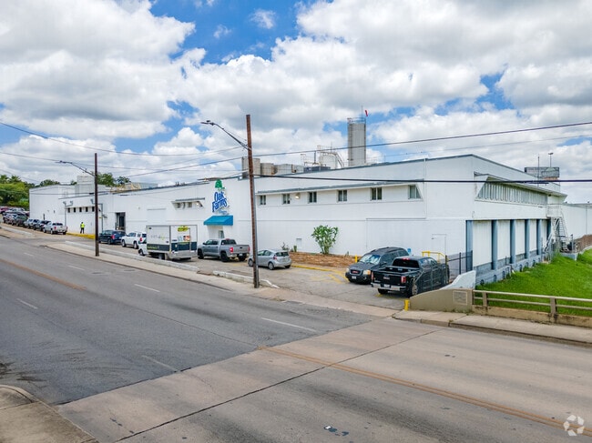
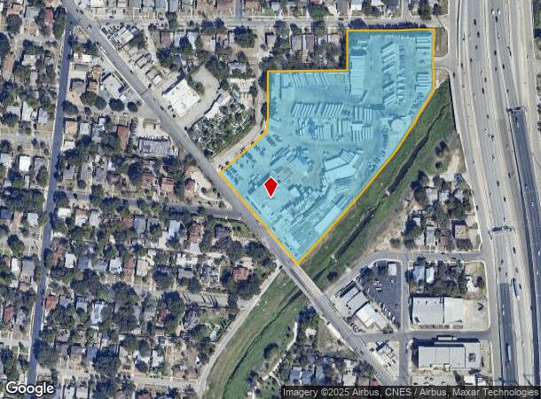
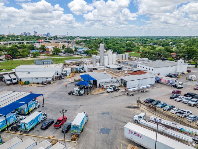
Property Record
1318 Fredericksburg Rd, San Antonio, TX 78201
NEARBY LISTINGS FOR SALE OR LEASE
Property Detail
1318 Fredericksburg Rd
San Antonio-New Braunfels, TX
Conv A/S Code
06499-000-0010
NCB 6499 BLK LOT 1, NCB 3243 BLK 1 LOT 1,2,3,22,23,24,26,P-100,P-101,P-102,P-103, NCB 3245 BLK 4 LOT NW 51.96 OF 20, P-104, NCB 3251 BLK 88 LOT 1, 15, W 29.72 OF 2 & 16, P-100, P-101, NCB 3252 BLK 87 LOT NW TRI OF 1 2009-MERGED PIDS 143211,143212,143
Warehouse
Bexar
AE
Texas
48029C0384H
1
2024
8.56 AC
2025
Northwest
180201
San Antonio
868,766 SF
DEMOGRAPHICS near 1318 Fredericksburg Rd
1 Mile
3 Mile
5 Mile
2024 Total Population
17,131
150,243
383,849
2029 Population
18,103
159,682
408,989
Pop Growth 2024-2029
+ 5.67%
+ 6.28%
+ 6.55%
Average Age
41
39
38
2024 Total Households
6,818
57,158
145,692
HH Growth 2024-2029
+ 5.85%
+ 6.83%
+ 6.95%
Median Household Inc
$46,709
$42,230
$44,055
Avg Household Size
2.40
2.40
2.50
2024 Avg HH Vehicles
2.00
2.00
2.00
Median Home Value
$183,620
$157,873
$168,527
Median Year Built
1946
1956
1962
Nearby Places
Map Layers
Map Styles
 Street
 Aerial
- Restaurants
- Banks
- Shops
- Fitness
- Groceries
PUBLIC TRANSPORTATION
COMMUTER RAIL
San Antonio Amtrak Station (Sunset Limited - Amtrak, Texas Eagle - Amtrak)
DRIVE
WALK
Distance
San Antonio Amtrak Station (Sunset Limited - Amtrak, Texas Eagle - Amtrak)
8 min
4.4 mi
AIRPORT
San Antonio International
DRIVE
WALK
Distance
San Antonio International
13 min
7.6 mi
Freight Ports
Calhoun Port
DRIVE
WALK
Distance
Calhoun Port
185 min
151.8 mi
Nearby Properties
Address
Land Use
TOTAL SIZE
Lot Size
Zoning
Address
Land Use
TOTAL SIZE
Lot Size
Zoning
443,000 SF
4.16 AC
Address
Land Use
TOTAL SIZE
Lot Size
Zoning
339,590 SF
3.12 AC
Address
Land Use
TOTAL SIZE
Lot Size
Zoning
443,560 SF
2.77 AC
Address
Land Use
TOTAL SIZE
Lot Size
Zoning
290,794 SF
0.62 AC
Address
Land Use
TOTAL SIZE
Lot Size
Zoning
5,106 SF
2.30 AC
Address
Land Use
TOTAL SIZE
Lot Size
Zoning
387,443 SF
0.89 AC
Address
Land Use
TOTAL SIZE
Lot Size
Zoning
43,834 SF
3.11 AC
Address
Land Use
TOTAL SIZE
Lot Size
Zoning
178,534 SF
1.32 AC
Address
Land Use
TOTAL SIZE
Lot Size
Zoning
103,425 SF
4.76 AC
Address
Land Use
TOTAL SIZE
Lot Size
Zoning
521,935 SF
2.17 AC
Address
Land Use
TOTAL SIZE
Lot Size
Zoning
495,840 SF
1.20 AC
Address
Land Use
TOTAL SIZE
Lot Size
Zoning
308,878 SF
1.23 AC
Address
Land Use
TOTAL SIZE
Lot Size
Zoning
11,915 SF
4.06 AC
Address
Land Use
TOTAL SIZE
Lot Size
Zoning
254,908 SF
1.92 AC
Address
Land Use
TOTAL SIZE
Lot Size
Zoning
173,422 SF
5.85 AC
Address
Land Use
TOTAL SIZE
Lot Size
Zoning
221,865 SF
3.12 AC
Address
Land Use
TOTAL SIZE
Lot Size
Zoning
262,082 SF
1.60 AC
Address
Land Use
TOTAL SIZE
Lot Size
Zoning
7,018 SF
3.24 AC
Address
Land Use
TOTAL SIZE
Lot Size
Zoning
163,858 SF
0.62 AC
Address
Land Use
TOTAL SIZE
Lot Size
Zoning
481,589 SF
5.29 AC
Address
Land Use
TOTAL SIZE
Lot Size
Zoning
31,334 SF
14.11 AC
Address
Land Use
TOTAL SIZE
Lot Size
Zoning
399,007 SF
22.03 AC
Address
Land Use
TOTAL SIZE
Lot Size
Zoning
360,853 SF
1.18 AC
Address
Land Use
TOTAL SIZE
Lot Size
Zoning
303,199 SF
9.88 AC
Address
Land Use
TOTAL SIZE
Lot Size
Zoning
38.73 AC
Address
Land Use
TOTAL SIZE
Lot Size
Zoning
13,153 SF
2.62 AC
Address
Land Use
TOTAL SIZE
Lot Size
Zoning
50.69 AC
Address
Land Use
TOTAL SIZE
Lot Size
Zoning
161,652 SF
1.79 AC
Address
Land Use
TOTAL SIZE
Lot Size
Zoning
11,915 SF
4.12 AC
Address
Land Use
TOTAL SIZE
Lot Size
Zoning
349,678 SF
0.83 AC
The World's #1 Commercial Real Estate Marketplace
Connect with us
© 2025 CoStar Group
The information above has been obtained from sources believed reliable. While we do not doubt its accuracy we have not verified it and make no guarantee, warranty or representation about it. It is your responsibility to independently confirm its accuracy and completeness. Any projections, opinions, assumptions, or estimates used are for example only and do not represent the current or future performance of the property. The value of this transaction to you depends on tax and other factors which should be evaluated by your tax, financial, and legal advisors. You and your advisors should conduct a careful, independent investigation of the property to determine to your satisfaction the suitability of the property for your needs.