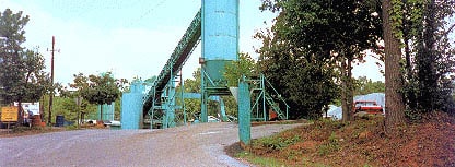
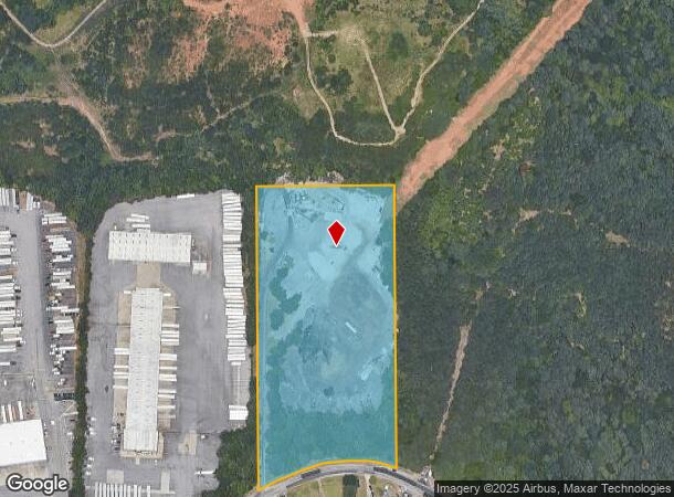
Property Record
1318 Henrico Rd, Conley, GA 30288
NEARBY LISTINGS FOR SALE OR LEASE
Property Detail
1318 Henrico Rd
15-047-01-002
DeKalb
Industrialacreage
Georgia
X
ii
13089C0137J
8 AC
2025
North Clayton/Airport
2025
Atlanta
023444
Atlanta-Sandy Springs-Roswell, GA
DEMOGRAPHICS near 1318 Henrico Rd
1 Mile
3 Mile
5 Mile
2024 Total Population
416
49,357
174,877
2029 Population
418
50,456
178,763
Pop Growth 2024-2029
+ 0.48%
+ 2.23%
+ 2.22%
Average Age
37
37
37
2024 Total Households
89
17,361
67,312
HH Growth 2024-2029
+ 1.12%
+ 2.29%
+ 2.39%
Median Household Inc
$87,500
$53,801
$53,275
Avg Household Size
2.80
2.70
2.50
2024 Avg HH Vehicles
2.00
2.00
2.00
Median Home Value
$288,461
$218,108
$246,608
Median Year Built
1996
1978
1976
Nearby Places
- Restaurants
- Banks
- Shops
- Fitness
- Groceries
PUBLIC TRANSPORTATION
AIRPORT
Hartsfield - Jackson Atlanta International
DRIVE
WALK
Distance
Hartsfield - Jackson Atlanta International
14 min
7.2 mi
Freight Ports
Georgia Ports - Savannah
DRIVE
WALK
Distance
Georgia Ports - Savannah
269 min
240.4 mi
Nearby Properties
Address
Land Use
TOTAL SIZE
Lot Size
Zoning
Address
Land Use
TOTAL SIZE
Lot Size
Zoning
432,056 SF
17.87 AC
C1
Address
Land Use
TOTAL SIZE
Lot Size
Zoning
54 AC
I2
Address
Land Use
TOTAL SIZE
Lot Size
Zoning
381,983 SF
52.54 AC
M
Address
Land Use
TOTAL SIZE
Lot Size
Zoning
210,538 SF
101.40 AC
X
Address
Land Use
TOTAL SIZE
Lot Size
Zoning
278,121 SF
20 AC
RM85
Address
Land Use
TOTAL SIZE
Lot Size
Zoning
381,923 SF
19.72 AC
M
Address
Land Use
TOTAL SIZE
Lot Size
Zoning
375,336 SF
22.76 AC
M
Address
Land Use
TOTAL SIZE
Lot Size
Zoning
59,807 SF
43.70 AC
X
Address
Land Use
TOTAL SIZE
Lot Size
Zoning
150,899 SF
21.89 AC
X
Address
Land Use
TOTAL SIZE
Lot Size
Zoning
814,461 SF
29.12 AC
RG2
Address
Land Use
TOTAL SIZE
Lot Size
Zoning
402,544 SF
20.43 AC
I1
Address
Land Use
TOTAL SIZE
Lot Size
Zoning
118,310 SF
10.90 AC
RM85
Address
Land Use
TOTAL SIZE
Lot Size
Zoning
321,464 SF
23.11 AC
HI
Address
Land Use
TOTAL SIZE
Lot Size
Zoning
44,365 SF
17.77 AC
M
Address
Land Use
TOTAL SIZE
Lot Size
Zoning
86,071 SF
18 AC
M
Address
Land Use
TOTAL SIZE
Lot Size
Zoning
250 SF
13.40 AC
C
Address
Land Use
TOTAL SIZE
Lot Size
Zoning
403,328 SF
31.30 AC
I1
Address
Land Use
TOTAL SIZE
Lot Size
Zoning
91,446 SF
14.80 AC
RM85
Address
Land Use
TOTAL SIZE
Lot Size
Zoning
1,150,236 SF
16.70 AC
RG2
Address
Land Use
TOTAL SIZE
Lot Size
Zoning
420,048 SF
27.09 AC
I1
Address
Land Use
TOTAL SIZE
Lot Size
Zoning
13,108 SF
28.02 AC
M
Address
Land Use
TOTAL SIZE
Lot Size
Zoning
129,064 SF
13.29 AC
RM75
Address
Land Use
TOTAL SIZE
Lot Size
Zoning
69,384 SF
29.86 AC
OD
Address
Land Use
TOTAL SIZE
Lot Size
Zoning
178,495 SF
14.47 AC
RM100
Address
Land Use
TOTAL SIZE
Lot Size
Zoning
Address
Land Use
TOTAL SIZE
Lot Size
Zoning
7,967 SF
7.84 AC
HI
Address
Land Use
TOTAL SIZE
Lot Size
Zoning
85,344 SF
44.02 AC
M
Address
Land Use
TOTAL SIZE
Lot Size
Zoning
133,718 SF
12.06 AC
I1
Address
Land Use
TOTAL SIZE
Lot Size
Zoning
73,184 SF
7.41 AC
RM85
Address
Land Use
TOTAL SIZE
Lot Size
Zoning
86.88 AC
M
The World's #1 Commercial Real Estate Marketplace
Connect with us
© 2025 CoStar Group
The information above has been obtained from sources believed reliable. While we do not doubt its accuracy we have not verified it and make no guarantee, warranty or representation about it. It is your responsibility to independently confirm its accuracy and completeness. Any projections, opinions, assumptions, or estimates used are for example only and do not represent the current or future performance of the property. The value of this transaction to you depends on tax and other factors which should be evaluated by your tax, financial, and legal advisors. You and your advisors should conduct a careful, independent investigation of the property to determine to your satisfaction the suitability of the property for your needs.