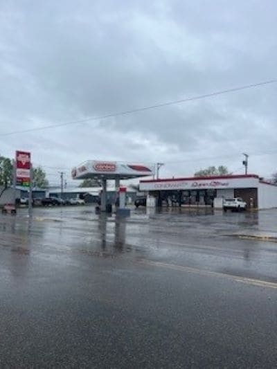
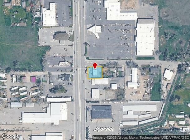
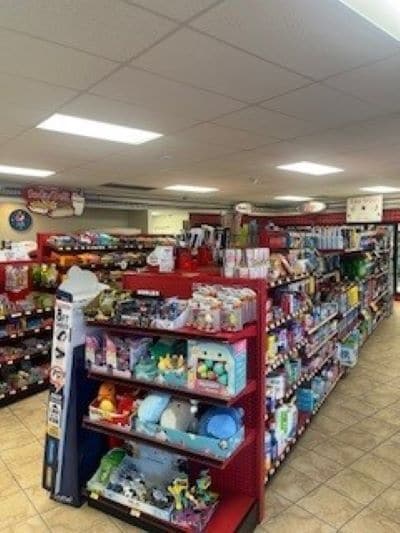
Property Record
1219 Main St, Billings, MT 59105
NEARBY LISTINGS FOR SALE OR LEASE
Property Detail
1219 Main St
Billings, MT
Logan Subd
03-1033-22-1-02-13-0000
S22, T01 N, R26 E, C.O.S. 169, PARCEL A, (LESS N5 STRIP) (LESS 400 SQ FT ST) (96) LOCATED IN LT 17 LOGAN SUB 2ND
Commercialnec
Yellowstone
X
Montana
30111C1280E
a
2024
0.31 AC
2025
Billings
000706
Other Market Areas
2,100 SF
DEMOGRAPHICS near 1219 Main St
1 Mile
3 Mile
5 Mile
2024 Total Population
11,763
40,492
77,574
2029 Population
12,786
43,919
83,780
Pop Growth 2024-2029
+ 8.70%
+ 8.46%
+ 8.00%
Average Age
39
39
39
2024 Total Households
4,971
16,291
32,031
HH Growth 2024-2029
+ 8.87%
+ 8.59%
+ 8.15%
Median Household Inc
$58,489
$67,103
$66,053
Avg Household Size
2.30
2.40
2.30
2024 Avg HH Vehicles
2.00
2.00
2.00
Median Home Value
$240,108
$276,401
$276,013
Median Year Built
1988
1985
1974
Nearby Places
- Restaurants
- Banks
- Shops
- Fitness
- Groceries
PUBLIC TRANSPORTATION
AIRPORT
Billings Logan International
DRIVE
WALK
Distance
Billings Logan International
22 min
7.5 mi
Freight Ports
Port of Everett
DRIVE
WALK
Distance
Port of Everett
890 min
844.7 mi
SALE & LEASE HISTORY
LISTING DATE
SALE/LEASE

May 23, 2024
For Sale
Nearby Properties
Address
Land Use
TOTAL SIZE
Lot Size
Zoning
Address
Land Use
TOTAL SIZE
Lot Size
Zoning
650,098 SF
53.35 AC
CI
Address
Land Use
TOTAL SIZE
Lot Size
Zoning
704,701 SF
9.06 AC
MCPZD
Address
Land Use
TOTAL SIZE
Lot Size
Zoning
240,253 SF
282.66 AC
HI
Address
Land Use
TOTAL SIZE
Lot Size
Zoning
6,000 SF
152.47 AC
PUBLIC-COU
Address
Land Use
TOTAL SIZE
Lot Size
Zoning
228,269 SF
44.60 AC
PUBLIC-CIT
Address
Land Use
TOTAL SIZE
Lot Size
Zoning
9.37 AC
P
Address
Land Use
TOTAL SIZE
Lot Size
Zoning
117,130 SF
29.86 AC
R-70
Address
Land Use
TOTAL SIZE
Lot Size
Zoning
141,056 SF
25.82 AC
PUBLIC-CIT
Address
Land Use
TOTAL SIZE
Lot Size
Zoning
234,444 SF
4.98 AC
MCPZD
Address
Land Use
TOTAL SIZE
Lot Size
Zoning
181,007 SF
19.57 AC
Address
Land Use
TOTAL SIZE
Lot Size
Zoning
48,717 SF
1.53 AC
MCPZD
Address
Land Use
TOTAL SIZE
Lot Size
Zoning
125,400 SF
2.41 AC
CI
Address
Land Use
TOTAL SIZE
Lot Size
Zoning
78,328 SF
7.78 AC
R9600-CITY
Address
Land Use
TOTAL SIZE
Lot Size
Zoning
68,022 SF
4.01 AC
CI
Address
Land Use
TOTAL SIZE
Lot Size
Zoning
53.34 AC
P
Address
Land Use
TOTAL SIZE
Lot Size
Zoning
57,112 SF
7.69 AC
Address
Land Use
TOTAL SIZE
Lot Size
Zoning
25,045 SF
10.77 AC
R-70
Address
Land Use
TOTAL SIZE
Lot Size
Zoning
110,086 SF
1.49 AC
MCPZD
Address
Land Use
TOTAL SIZE
Lot Size
Zoning
34,632 SF
MCPZD
Address
Land Use
TOTAL SIZE
Lot Size
Zoning
43.08 AC
R-96
Address
Land Use
TOTAL SIZE
Lot Size
Zoning
53,483 SF
1.13 AC
RP
Address
Land Use
TOTAL SIZE
Lot Size
Zoning
41.37 AC
P
Address
Land Use
TOTAL SIZE
Lot Size
Zoning
72,949 SF
4.12 AC
HC
Address
Land Use
TOTAL SIZE
Lot Size
Zoning
128,015 SF
17.89 AC
CI
Address
Land Use
TOTAL SIZE
Lot Size
Zoning
55,815 SF
1.46 AC
CC
Address
Land Use
TOTAL SIZE
Lot Size
Zoning
36,786 SF
11.50 AC
R9600-CITY
Address
Land Use
TOTAL SIZE
Lot Size
Zoning
46,680 SF
11.18 AC
R-96
Address
Land Use
TOTAL SIZE
Lot Size
Zoning
42,704 SF
8.56 AC
R-70
Address
Land Use
TOTAL SIZE
Lot Size
Zoning
48,217 SF
9.99 AC
R-96
Address
Land Use
TOTAL SIZE
Lot Size
Zoning
60,615 SF
4.25 AC
R-70
The World's #1 Commercial Real Estate Marketplace
Connect with us
© 2025 CoStar Group
The information above has been obtained from sources believed reliable. While we do not doubt its accuracy we have not verified it and make no guarantee, warranty or representation about it. It is your responsibility to independently confirm its accuracy and completeness. Any projections, opinions, assumptions, or estimates used are for example only and do not represent the current or future performance of the property. The value of this transaction to you depends on tax and other factors which should be evaluated by your tax, financial, and legal advisors. You and your advisors should conduct a careful, independent investigation of the property to determine to your satisfaction the suitability of the property for your needs.