Property Record
13191 Reams Rd, Windermere, FL 34786
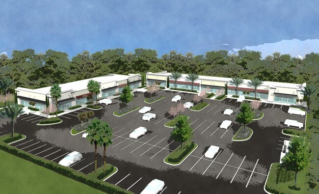

Property Detail
13191 Reams Rd
02-2427-7135-03-000
REAMS ROAD DEVELOPMENT 88/51 LOT 3
Storebuilding
ORANGE
C-1
Florida
AE The base floodplain where base flood elevations are provided. AE Zones are now used on new format FIRMs instead of A1-A30 Zones.
3
2025
1.51 AC
2025
SW Orange Outlying
017112
Orlando
6,218 SF
Orlando-Kissimmee-Sanford, FL
NEARBY LISTINGS FOR SALE OR LEASE
-
-
View all Windermere listings for lease on LoopNet.com
DEMOGRAPHICS near 13191 Reams Rd
1 mile
3 mile
5 mile
2025 Total Population
4,654
43,015
103,498
2030 Population
5,124
47,503
114,922
Pop Growth 2025-2030
+ 10.10%
+ 10.43%
+ 11.04%
Average Age
35
37
38
2025 Total Households
1,629
14,674
35,429
HH Growth 2025-2030
+ 10.44%
+ 10.82%
+ 11.44%
Median Household Inc
$109,905
$119,199
$127,075
Avg Household Size
2.80
2.90
2.90
2025 Avg HH Vehicles
2.00
2.00
2.00
Median Home Value
$554,706
$631,339
$671,811
Median Year Built
2011
2010
2010
Nearby Places
Map Layers
Map Styles
 Street
 Aerial
Transit
 Traffic
 Biking
Places
Listings with unknown addresses are not visible on the map
- Restaurants
- Banks
- Shops
- Fitness
- Groceries
PUBLIC TRANSPORTATION
AIRPORT
Orlando International
Drive
Walk
Distance
Orlando International
38 min
25.4 mi
Freight Ports
Port Canaveral
Drive
Walk
Distance
Port Canaveral
86 min
68.0 mi
SALE & LEASE HISTORY
LISTING DATE
SALE/LEASE

Dec 08, 2017
For Lease
Aug 08, 2019
For Lease
Nearby Properties
Address
Land Use
TOTAL SIZE
Lot Size
Zoning
Address
Land Use
TOTAL SIZE
Lot Size
Zoning
2,075,986 SF
143.39 AC
E
Address
Land Use
TOTAL SIZE
Lot Size
Zoning
350,704 SF
4.65 AC
H/R
Address
Land Use
TOTAL SIZE
Lot Size
Zoning
728,794 SF
26.46 AC
E
Address
Land Use
TOTAL SIZE
Lot Size
Zoning
266,518 SF
9.31 AC
H/R
Address
Land Use
TOTAL SIZE
Lot Size
Zoning
727,436 SF
50.11 AC
H/R
Address
Land Use
TOTAL SIZE
Lot Size
Zoning
104,734 SF
4.12 AC
H/R
Address
Land Use
TOTAL SIZE
Lot Size
Zoning
545,861 SF
2.83 AC
H/R
Address
Land Use
TOTAL SIZE
Lot Size
Zoning
1,012,115 SF
50.12 AC
H/R
Address
Land Use
TOTAL SIZE
Lot Size
Zoning
470,580 SF
40.38 AC
H/R
Address
Land Use
TOTAL SIZE
Lot Size
Zoning
802,487 SF
29.77 AC
H/R
Address
Land Use
TOTAL SIZE
Lot Size
Zoning
141,460 SF
3.79 AC
H/R
Address
Land Use
TOTAL SIZE
Lot Size
Zoning
557,262 SF
51.62 AC
H/R
Address
Land Use
TOTAL SIZE
Lot Size
Zoning
246,220 SF
25 AC
C
Address
Land Use
TOTAL SIZE
Lot Size
Zoning
193,623 SF
526.19 AC
E
Address
Land Use
TOTAL SIZE
Lot Size
Zoning
883,748 SF
119.44 AC
SUP-FAC
Address
Land Use
TOTAL SIZE
Lot Size
Zoning
491,851 SF
13.95 AC
P-D
Address
Land Use
TOTAL SIZE
Lot Size
Zoning
446,359 SF
17.15 AC
P-D
Address
Land Use
TOTAL SIZE
Lot Size
Zoning
495,168 SF
21.91 AC
P-D
Address
Land Use
TOTAL SIZE
Lot Size
Zoning
73,290 SF
129.83 AC
C
Address
Land Use
TOTAL SIZE
Lot Size
Zoning
474,869 SF
17.37 AC
P-D
Address
Land Use
TOTAL SIZE
Lot Size
Zoning
386,327 SF
1.21 AC
P-D
Address
Land Use
TOTAL SIZE
Lot Size
Zoning
65,886 SF
5,403.17 AC
C
Address
Land Use
TOTAL SIZE
Lot Size
Zoning
272,239 SF
8.79 AC
P-D
Address
Land Use
TOTAL SIZE
Lot Size
Zoning
33,992 SF
Address
Land Use
TOTAL SIZE
Lot Size
Zoning
175,271 SF
25.45 AC
P-D
Address
Land Use
TOTAL SIZE
Lot Size
Zoning
101,482 SF
21.01 AC
P-D
Address
Land Use
TOTAL SIZE
Lot Size
Zoning
177,081 SF
5.18 AC
P-D
Address
Land Use
TOTAL SIZE
Lot Size
Zoning
148,675 SF
35.59 AC
C
Address
Land Use
TOTAL SIZE
Lot Size
Zoning
4.93 AC
P-D
Address
Land Use
TOTAL SIZE
Lot Size
Zoning
109,728 SF
18.28 AC
PF
The World's #1 Commercial Real Estate Marketplace
Connect with us
© 2026 CoStar Group
The information above has been obtained from sources believed reliable. While we do not doubt its accuracy we have not verified it and make no guarantee, warranty or representation about it. It is your responsibility to independently confirm its accuracy and completeness. Any projections, opinions, assumptions, or estimates used are for example only and do not represent the current or future performance of the property. The value of this transaction to you depends on tax and other factors which should be evaluated by your tax, financial, and legal advisors. You and your advisors should conduct a careful, independent investigation of the property to determine to your satisfaction the suitability of the property for your needs.