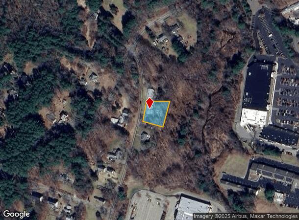
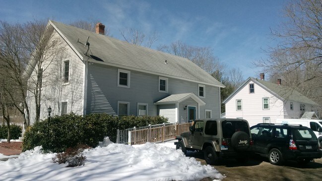
Property Record
132 Conantville Rd, Mansfield Center, CT 06250

NEARBY LISTINGS FOR SALE OR LEASE
Property Detail
132 Conantville Rd
Hartford-West Hartford-East Hartford, CT
Tolland
MANS-000038-000105-000005
Connecticut
Commercialbuilding
5
2024
0.40 AC
2025
Tolland County
881500
Hartford
2,688 SF
DEMOGRAPHICS near 132 Conantville Rd
1 Mile
3 Mile
5 Mile
2024 Total Population
4,518
27,148
40,296
2029 Population
4,583
27,181
40,239
Pop Growth 2024-2029
+ 1.44%
+ 0.12%
(0.14%)
Average Age
39
37
38
2024 Total Households
1,980
9,939
14,312
HH Growth 2024-2029
+ 1.41%
(0.02%)
(0.29%)
Median Household Inc
$34,697
$48,970
$53,175
Avg Household Size
2.20
2.30
2.40
2024 Avg HH Vehicles
1.00
2.00
2.00
Median Home Value
$205,161
$180,508
$215,669
Median Year Built
1985
1961
1966
Nearby Places
Map Layers
Map Styles
 Street
 Aerial
- Restaurants
- Banks
- Shops
- Fitness
- Groceries
PUBLIC TRANSPORTATION
AIRPORT
Bradley International
DRIVE
WALK
Distance
Bradley International
67 min
43.3 mi
SALE & LEASE HISTORY
LISTING DATE
SALE/LEASE

Apr 08, 2017
For Sale
Apr 03, 2017
For Sale
Nearby Properties
Address
Land Use
TOTAL SIZE
Lot Size
Zoning
Address
Land Use
TOTAL SIZE
Lot Size
Zoning
14.62 AC
B4
Address
Land Use
TOTAL SIZE
Lot Size
Zoning
47,712 SF
1 AC
I
Address
Land Use
TOTAL SIZE
Lot Size
Zoning
176,832 SF
I
Address
Land Use
TOTAL SIZE
Lot Size
Zoning
33,366 SF
R6
Address
Land Use
TOTAL SIZE
Lot Size
Zoning
Address
Land Use
TOTAL SIZE
Lot Size
Zoning
145,144 SF
R6
Address
Land Use
TOTAL SIZE
Lot Size
Zoning
79,493 SF
16.10 AC
RAR90
Address
Land Use
TOTAL SIZE
Lot Size
Zoning
14.50 AC
R20
Address
Land Use
TOTAL SIZE
Lot Size
Zoning
111,757 SF
6.74 AC
RL
Address
Land Use
TOTAL SIZE
Lot Size
Zoning
90,450 SF
R6
Address
Land Use
TOTAL SIZE
Lot Size
Zoning
99,901 SF
1 AC
I
Address
Land Use
TOTAL SIZE
Lot Size
Zoning
61,837 SF
I
Address
Land Use
TOTAL SIZE
Lot Size
Zoning
73,691 SF
R6
Address
Land Use
TOTAL SIZE
Lot Size
Zoning
102,324 SF
1 AC
I
Address
Land Use
TOTAL SIZE
Lot Size
Zoning
99,139 SF
R6
Address
Land Use
TOTAL SIZE
Lot Size
Zoning
86,899 SF
18.27 AC
R3
Address
Land Use
TOTAL SIZE
Lot Size
Zoning
68,508 SF
R6
Address
Land Use
TOTAL SIZE
Lot Size
Zoning
316,812 SF
39.88 AC
R4
Address
Land Use
TOTAL SIZE
Lot Size
Zoning
57,648 SF
R6
Address
Land Use
TOTAL SIZE
Lot Size
Zoning
22.30 AC
RL
Address
Land Use
TOTAL SIZE
Lot Size
Zoning
28,231 SF
R6
Address
Land Use
TOTAL SIZE
Lot Size
Zoning
126,220 SF
1 AC
I
Address
Land Use
TOTAL SIZE
Lot Size
Zoning
158,766 SF
3.91 AC
R6
Address
Land Use
TOTAL SIZE
Lot Size
Zoning
86,684 SF
1 AC
I
Address
Land Use
TOTAL SIZE
Lot Size
Zoning
152 AC
I
Address
Land Use
TOTAL SIZE
Lot Size
Zoning
24,313 SF
R6
Address
Land Use
TOTAL SIZE
Lot Size
Zoning
275,230 SF
27.63 AC
PB1
Address
Land Use
TOTAL SIZE
Lot Size
Zoning
200 AC
R2 - 1
Address
Land Use
TOTAL SIZE
Lot Size
Zoning
6,340 SF
I
Address
Land Use
TOTAL SIZE
Lot Size
Zoning
63,224 SF
2.68 AC
R6
The World's #1 Commercial Real Estate Marketplace
Connect with us
© 2025 CoStar Group
The information above has been obtained from sources believed reliable. While we do not doubt its accuracy we have not verified it and make no guarantee, warranty or representation about it. It is your responsibility to independently confirm its accuracy and completeness. Any projections, opinions, assumptions, or estimates used are for example only and do not represent the current or future performance of the property. The value of this transaction to you depends on tax and other factors which should be evaluated by your tax, financial, and legal advisors. You and your advisors should conduct a careful, independent investigation of the property to determine to your satisfaction the suitability of the property for your needs.