Property Record
132 Keller St, Petaluma, CA 94952


This Property Is For Sale
Property Detail
132 Keller St
006-363-026
2020 SPLIT PER PM 408 PARCEL 2
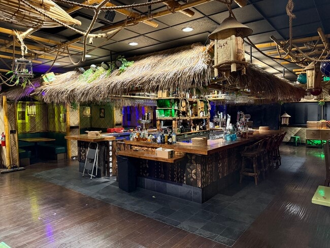
Restaurantbuilding
Sonoma
B and X Area of moderate flood hazard, usually the area between the limits of the 100-year and 500-year floods.
California
2025
0.14 AC
2025
Petaluma/Cotati/Rohnert
150701
North Bay/Santa Rosa
5,860 SF
Santa Rosa-Petaluma, CA
NEARBY LISTINGS FOR SALE OR LEASE
DEMOGRAPHICS near 132 Keller St
1 mile
3 mile
5 mile
2025 Total Population
16,287
63,611
67,829
2030 Population
16,345
63,461
67,394
Pop Growth 2025-2030
+ 0.36%
(0.24%)
(0.64%)
Average Age
44
44
44
2025 Total Households
6,751
24,744
26,458
HH Growth 2025-2030
+ 0.39%
(0.19%)
(0.62%)
Median Household Inc
$110,239
$112,285
$112,315
Avg Household Size
2.30
2.50
2.50
2025 Avg HH Vehicles
2.00
2.00
2.00
Median Home Value
$930,758
$835,962
$851,912
Median Year Built
1963
1979
1979
Nearby Places
Map Layers
Map Styles
 Street
 Aerial
Layers
 Traffic
 Biking
Places
Listings with unknown addresses are not visible on the map
- Restaurants
- Banks
- Shops
- Fitness
- Groceries
PUBLIC TRANSPORTATION
COMMUTER RAIL
Drive
Walk
Distance
2 min
11 min
0.5 mi
Drive
Walk
Distance
8 min
3.1 mi
AIRPORT
Charles M Schulz - Sonoma County
Drive
Walk
Distance
Charles M Schulz - Sonoma County
33 min
24.7 mi
Nearby Properties
Address
Land Use
TOTAL SIZE
Lot Size
Zoning
Address
Land Use
TOTAL SIZE
Lot Size
Zoning
456,584 SF
32.23 AC
CITYPE
Address
Land Use
TOTAL SIZE
Lot Size
Zoning
0.76 AC
ML
Address
Land Use
TOTAL SIZE
Lot Size
Zoning
226,772 SF
8.05 AC
Address
Land Use
TOTAL SIZE
Lot Size
Zoning
38,083 SF
16.14 AC
Address
Land Use
TOTAL SIZE
Lot Size
Zoning
3,967 SF
5.03 AC
CITYPE
Address
Land Use
TOTAL SIZE
Lot Size
Zoning
150,025 SF
1.48 AC
Address
Land Use
TOTAL SIZE
Lot Size
Zoning
134,732 SF
2.05 AC
Address
Land Use
TOTAL SIZE
Lot Size
Zoning
165,541 SF
12.61 AC
Address
Land Use
TOTAL SIZE
Lot Size
Zoning
63,000 SF
5.40 AC
CITYPE
Address
Land Use
TOTAL SIZE
Lot Size
Zoning
137,270 SF
10.04 AC
Address
Land Use
TOTAL SIZE
Lot Size
Zoning
35,408 SF
2.66 AC
Address
Land Use
TOTAL SIZE
Lot Size
Zoning
82,704 SF
14.63 AC
CITYPE
Address
Land Use
TOTAL SIZE
Lot Size
Zoning
59,351 SF
14.53 AC
Address
Land Use
TOTAL SIZE
Lot Size
Zoning
83,653 SF
1.18 AC
Address
Land Use
TOTAL SIZE
Lot Size
Zoning
32,000 SF
5.89 AC
PCD
Address
Land Use
TOTAL SIZE
Lot Size
Zoning
98,382 SF
6.83 AC
SP
Address
Land Use
TOTAL SIZE
Lot Size
Zoning
23,979 SF
5.85 AC
Address
Land Use
TOTAL SIZE
Lot Size
Zoning
63,959 SF
7.13 AC
Address
Land Use
TOTAL SIZE
Lot Size
Zoning
72,576 SF
8.39 AC
Address
Land Use
TOTAL SIZE
Lot Size
Zoning
109,993 SF
2.31 AC
Address
Land Use
TOTAL SIZE
Lot Size
Zoning
195,837 SF
16.32 AC
PCD
Address
Land Use
TOTAL SIZE
Lot Size
Zoning
85,582 SF
2.61 AC
CITYPE
Address
Land Use
TOTAL SIZE
Lot Size
Zoning
83,109 SF
9.56 AC
Address
Land Use
TOTAL SIZE
Lot Size
Zoning
5,640 SF
7.31 AC
CITYPE
Address
Land Use
TOTAL SIZE
Lot Size
Zoning
20,728 SF
10.36 AC
ML
Address
Land Use
TOTAL SIZE
Lot Size
Zoning
73,279 SF
0.96 AC
MG
Address
Land Use
TOTAL SIZE
Lot Size
Zoning
70,110 SF
1.11 AC
CITYPE
Address
Land Use
TOTAL SIZE
Lot Size
Zoning
10,000 SF
16.50 AC
Address
Land Use
TOTAL SIZE
Lot Size
Zoning
94,000 SF
4.87 AC
The World's #1 Commercial Real Estate Marketplace
Connect with us
© 2026 CoStar Group
The information above has been obtained from sources believed reliable. While we do not doubt its accuracy we have not verified it and make no guarantee, warranty or representation about it. It is your responsibility to independently confirm its accuracy and completeness. Any projections, opinions, assumptions, or estimates used are for example only and do not represent the current or future performance of the property. The value of this transaction to you depends on tax and other factors which should be evaluated by your tax, financial, and legal advisors. You and your advisors should conduct a careful, independent investigation of the property to determine to your satisfaction the suitability of the property for your needs.