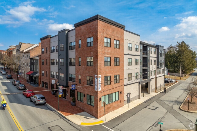
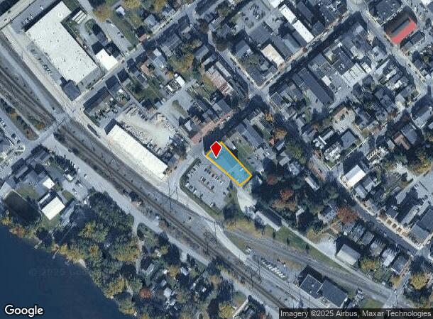
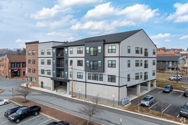
Property Record
132 Locust St, Leola, PA 17540
Current Lease Availabilities
NEARBY LISTINGS FOR SALE OR LEASE
Property Detail
132 Locust St
110-72629-0-0000
Lancaster
Commercialnec
Pennsylvania
2024
0.33 AC
2025
Columbia/Washington Boro
013002
Philadelphia
6,404 SF
Lancaster, PA
DEMOGRAPHICS near 132 Locust St
1 Mile
3 Mile
5 Mile
2024 Total Population
9,375
22,582
47,805
2029 Population
9,493
22,847
48,227
Pop Growth 2024-2029
+ 1.26%
+ 1.17%
+ 0.88%
Average Age
40
41
41
2024 Total Households
3,943
9,204
18,956
HH Growth 2024-2029
+ 1.24%
+ 1.17%
+ 0.91%
Median Household Inc
$45,937
$57,174
$74,215
Avg Household Size
2.30
2.40
2.50
2024 Avg HH Vehicles
1.00
2.00
2.00
Median Home Value
$107,368
$173,210
$223,271
Median Year Built
1947
1956
1973
Nearby Places
- Restaurants
- Banks
- Shops
- Fitness
- Groceries
PUBLIC TRANSPORTATION
COMMUTER RAIL
Mount Joy Amtrak (Keystone Service - Amtrak)
DRIVE
WALK
Distance
Mount Joy Amtrak (Keystone Service - Amtrak)
12 min
7.0 mi
AIRPORT
Harrisburg International
DRIVE
WALK
Distance
Harrisburg International
38 min
21.2 mi
Freight Ports
Port of Baltimore
DRIVE
WALK
Distance
Port of Baltimore
97 min
68.4 mi
Nearby Properties
Address
Land Use
TOTAL SIZE
Lot Size
Zoning
Address
Land Use
TOTAL SIZE
Lot Size
Zoning
215,601 SF
50.74 AC
R-3
Address
Land Use
TOTAL SIZE
Lot Size
Zoning
144,849 SF
10 AC
Address
Land Use
TOTAL SIZE
Lot Size
Zoning
168,819 SF
38.90 AC
INSR
Address
Land Use
TOTAL SIZE
Lot Size
Zoning
64,326 SF
2.20 AC
INSR
Address
Land Use
TOTAL SIZE
Lot Size
Zoning
164,150 SF
15.68 AC
Address
Land Use
TOTAL SIZE
Lot Size
Zoning
64,756 SF
8.70 AC
C-2
Address
Land Use
TOTAL SIZE
Lot Size
Zoning
14.39 AC
I
Address
Land Use
TOTAL SIZE
Lot Size
Zoning
52,704 SF
14.64 AC
R
Address
Land Use
TOTAL SIZE
Lot Size
Zoning
88,224 SF
38.58 AC
INSR
Address
Land Use
TOTAL SIZE
Lot Size
Zoning
56,389 SF
10.16 AC
Address
Land Use
TOTAL SIZE
Lot Size
Zoning
105,327 SF
13.80 AC
C-2
Address
Land Use
TOTAL SIZE
Lot Size
Zoning
54,597 SF
13.70 AC
I-2
Address
Land Use
TOTAL SIZE
Lot Size
Zoning
121,370 SF
16 AC
I-1
Address
Land Use
TOTAL SIZE
Lot Size
Zoning
83,124 SF
2.80 AC
HDRM
Address
Land Use
TOTAL SIZE
Lot Size
Zoning
49,993 SF
4.07 AC
INSR
Address
Land Use
TOTAL SIZE
Lot Size
Zoning
103,550 SF
1 AC
HDR
Address
Land Use
TOTAL SIZE
Lot Size
Zoning
70,122 SF
23.30 AC
INSR
Address
Land Use
TOTAL SIZE
Lot Size
Zoning
132,736 SF
10.81 AC
LI
Address
Land Use
TOTAL SIZE
Lot Size
Zoning
125,359 SF
7.74 AC
I
Address
Land Use
TOTAL SIZE
Lot Size
Zoning
594,615 SF
51.70 AC
GI
Address
Land Use
TOTAL SIZE
Lot Size
Zoning
27,072 SF
14.86 AC
RS
Address
Land Use
TOTAL SIZE
Lot Size
Zoning
129,444 SF
17.70 AC
I
Address
Land Use
TOTAL SIZE
Lot Size
Zoning
45,836 SF
3.90 AC
HC
Address
Land Use
TOTAL SIZE
Lot Size
Zoning
76,103 SF
17.51 AC
ID
Address
Land Use
TOTAL SIZE
Lot Size
Zoning
4,623 SF
211.70 AC
A
Address
Land Use
TOTAL SIZE
Lot Size
Zoning
89,401 SF
7.50 AC
C-2
Address
Land Use
TOTAL SIZE
Lot Size
Zoning
1,144 SF
152.51 AC
R
Address
Land Use
TOTAL SIZE
Lot Size
Zoning
32,134 SF
1.64 AC
MDR
Address
Land Use
TOTAL SIZE
Lot Size
Zoning
9,080 SF
563.26 AC
AG
The World's #1 Commercial Real Estate Marketplace
Connect with us
© 2025 CoStar Group
The information above has been obtained from sources believed reliable. While we do not doubt its accuracy we have not verified it and make no guarantee, warranty or representation about it. It is your responsibility to independently confirm its accuracy and completeness. Any projections, opinions, assumptions, or estimates used are for example only and do not represent the current or future performance of the property. The value of this transaction to you depends on tax and other factors which should be evaluated by your tax, financial, and legal advisors. You and your advisors should conduct a careful, independent investigation of the property to determine to your satisfaction the suitability of the property for your needs.