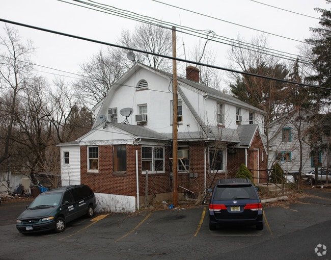
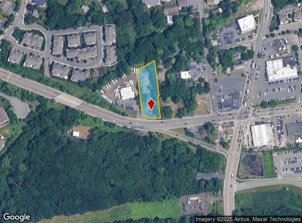
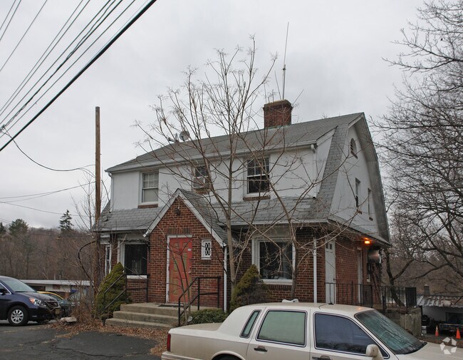
Property Record
132 Rt 59, Monsey, NY 10952
NEARBY LISTINGS FOR SALE OR LEASE
Property Detail
132 Rt 59
392689-056-015-0002-030-000-0000
Rockland
Commercialacreage
New York
X
30.0
36087C0152G
0.78 AC
2023
Ramapo
2024
Northern New Jersey
012113
New York-Jersey City-White Plains, NY-NJ
1,928 SF
DEMOGRAPHICS near 132 Rt 59
1 Mile
3 Mile
5 Mile
2024 Total Population
28,806
130,448
242,920
2029 Population
28,413
129,721
242,045
Pop Growth 2024-2029
(1.36%)
(0.56%)
(0.36%)
Average Age
27
32
36
2024 Total Households
6,258
33,147
71,152
HH Growth 2024-2029
(1.39%)
(0.53%)
(0.33%)
Median Household Inc
$55,518
$79,631
$101,878
Avg Household Size
4.20
3.70
3.20
2024 Avg HH Vehicles
1.00
2.00
2.00
Median Home Value
$703,871
$623,082
$618,373
Median Year Built
1979
1974
1972
Nearby Places
- Restaurants
- Banks
- Shops
- Fitness
- Groceries
PUBLIC TRANSPORTATION
COMMUTER RAIL
Spring Valley (Pascack Valley Line - NJ Transit Commuter Rail (NJ Transit))
DRIVE
WALK
Distance
Spring Valley (Pascack Valley Line - NJ Transit Commuter Rail (NJ Transit))
3 min
1.7 mi
Nanuet (Pascack Valley Line - NJ Transit Commuter Rail (NJ Transit))
DRIVE
WALK
Distance
Nanuet (Pascack Valley Line - NJ Transit Commuter Rail (NJ Transit))
7 min
3.9 mi
AIRPORT
Westchester County
DRIVE
WALK
Distance
Westchester County
37 min
26.1 mi
LaGuardia
DRIVE
WALK
Distance
LaGuardia
54 min
34.2 mi
New York Stewart International
DRIVE
WALK
Distance
New York Stewart International
53 min
39.9 mi
Freight Ports
Maher Terminal
DRIVE
WALK
Distance
Maher Terminal
55 min
38.8 mi
Nearby Properties
Address
Land Use
TOTAL SIZE
Lot Size
Zoning
Address
Land Use
TOTAL SIZE
Lot Size
Zoning
609,540 SF
174.09 AC
R-50
Address
Land Use
TOTAL SIZE
Lot Size
Zoning
116,650 SF
39.20 AC
05
Address
Land Use
TOTAL SIZE
Lot Size
Zoning
152,854 SF
18.75 AC
RS
Address
Land Use
TOTAL SIZE
Lot Size
Zoning
2,220 SF
15.10 AC
02 - SINGL
Address
Land Use
TOTAL SIZE
Lot Size
Zoning
859,490 SF
49.12 AC
PI
Address
Land Use
TOTAL SIZE
Lot Size
Zoning
70,527 SF
10.20 AC
RSH
Address
Land Use
TOTAL SIZE
Lot Size
Zoning
117,950 SF
11.13 AC
05
Address
Land Use
TOTAL SIZE
Lot Size
Zoning
141,846 SF
12.81 AC
05
Address
Land Use
TOTAL SIZE
Lot Size
Zoning
275,724 SF
40 AC
R1
Address
Land Use
TOTAL SIZE
Lot Size
Zoning
4,492 SF
14.50 AC
Address
Land Use
TOTAL SIZE
Lot Size
Zoning
101,628 SF
9.23 AC
05
Address
Land Use
TOTAL SIZE
Lot Size
Zoning
38,056 SF
21.21 AC
R-15C
Address
Land Use
TOTAL SIZE
Lot Size
Zoning
78,895 SF
18.20 AC
Address
Land Use
TOTAL SIZE
Lot Size
Zoning
1,547 SF
6.60 AC
Address
Land Use
TOTAL SIZE
Lot Size
Zoning
282,001 SF
49.29 AC
RR50
Address
Land Use
TOTAL SIZE
Lot Size
Zoning
125,097 SF
4.60 AC
05
Address
Land Use
TOTAL SIZE
Lot Size
Zoning
121,674 SF
11.53 AC
Address
Land Use
TOTAL SIZE
Lot Size
Zoning
243,977 SF
27.29 AC
R40
Address
Land Use
TOTAL SIZE
Lot Size
Zoning
148,712 SF
34.01 AC
PLI
Address
Land Use
TOTAL SIZE
Lot Size
Zoning
66,669 SF
1.71 AC
Address
Land Use
TOTAL SIZE
Lot Size
Zoning
338,337 SF
21.12 AC
05
Address
Land Use
TOTAL SIZE
Lot Size
Zoning
227,607 SF
12.99 AC
RSH
Address
Land Use
TOTAL SIZE
Lot Size
Zoning
190,948 SF
13.54 AC
RS
Address
Land Use
TOTAL SIZE
Lot Size
Zoning
61,824 SF
4.18 AC
C
Address
Land Use
TOTAL SIZE
Lot Size
Zoning
35,648 SF
10 AC
NS
Address
Land Use
TOTAL SIZE
Lot Size
Zoning
98,073 SF
14.55 AC
Address
Land Use
TOTAL SIZE
Lot Size
Zoning
91,625 SF
7.12 AC
R-15C
Address
Land Use
TOTAL SIZE
Lot Size
Zoning
149,965 SF
26.04 AC
R35
Address
Land Use
TOTAL SIZE
Lot Size
Zoning
99,420 SF
3.90 AC
LI
Address
Land Use
TOTAL SIZE
Lot Size
Zoning
110,145 SF
7.16 AC
R-35
The World's #1 Commercial Real Estate Marketplace
Connect with us
© 2025 CoStar Group
The information above has been obtained from sources believed reliable. While we do not doubt its accuracy we have not verified it and make no guarantee, warranty or representation about it. It is your responsibility to independently confirm its accuracy and completeness. Any projections, opinions, assumptions, or estimates used are for example only and do not represent the current or future performance of the property. The value of this transaction to you depends on tax and other factors which should be evaluated by your tax, financial, and legal advisors. You and your advisors should conduct a careful, independent investigation of the property to determine to your satisfaction the suitability of the property for your needs.