Property Record
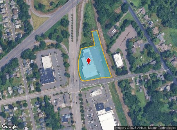
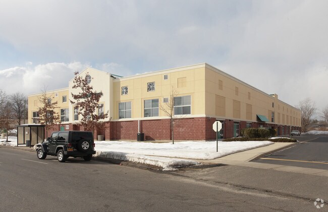
132 Silas Deane Hwy, Wethersfield, CT 06109

NEARBY LISTINGS FOR SALE OR LEASE
Property Detail
132 Silas Deane Hwy
Commercialnec
Hartford
X
Connecticut
09003C0506G
2.26 AC
2025
Wethersfield
2025
Hartford
492300
Hartford-West Hartford-East Hartford, CT
87,888 SF
WETH-000167-000000-000018
DEMOGRAPHICS near 132 Silas Deane Hwy
1 Mile
3 Mile
5 Mile
2024 Total Population
11,220
100,368
263,885
2029 Population
11,033
99,801
262,482
Pop Growth 2024-2029
(1.67%)
(0.56%)
(0.53%)
Average Age
39
38
40
2024 Total Households
4,247
40,034
108,717
HH Growth 2024-2029
(1.67%)
(0.38%)
(0.45%)
Median Household Inc
$72,830
$56,667
$63,985
Avg Household Size
2.50
2.40
2.30
2024 Avg HH Vehicles
2.00
1.00
1.00
Median Home Value
$243,672
$223,567
$255,017
Median Year Built
1948
1955
1957
Nearby Places
Map Layers
Map Styles
 Street
 Aerial
- Restaurants
- Banks
- Shops
- Fitness
- Groceries
PUBLIC TRANSPORTATION
COMMUTER RAIL
DRIVE
WALK
Distance
7 min
3.5 mi
DRIVE
WALK
Distance
7 min
4.0 mi
AIRPORT
Bradley International
DRIVE
WALK
Distance
Bradley International
36 min
20.3 mi
Tweed/New Haven
DRIVE
WALK
Distance
Tweed/New Haven
53 min
37.8 mi
Freight Ports
Port of New Haven
DRIVE
WALK
Distance
Port of New Haven
48 min
35.5 mi
Nearby Properties
Address
Land Use
TOTAL SIZE
Lot Size
Zoning
Address
Land Use
TOTAL SIZE
Lot Size
Zoning
147,644 SF
0.19 AC
CAMP
Address
Land Use
TOTAL SIZE
Lot Size
Zoning
173,601 SF
1.56 AC
DT-1
Address
Land Use
TOTAL SIZE
Lot Size
Zoning
516,804 SF
32.98 AC
CAMP
Address
Land Use
TOTAL SIZE
Lot Size
Zoning
15.73 AC
CAMP
Address
Land Use
TOTAL SIZE
Lot Size
Zoning
149.23 AC
DDD1
Address
Land Use
TOTAL SIZE
Lot Size
Zoning
69.42 AC
CT R
Address
Land Use
TOTAL SIZE
Lot Size
Zoning
8.89 AC
MX-2
Address
Land Use
TOTAL SIZE
Lot Size
Zoning
1,125,149 SF
1.14 AC
DT-1
Address
Land Use
TOTAL SIZE
Lot Size
Zoning
205,719 SF
12.15 AC
MX-2
Address
Land Use
TOTAL SIZE
Lot Size
Zoning
9.92 AC
DDD1
Address
Land Use
TOTAL SIZE
Lot Size
Zoning
20.41 AC
MX-2
Address
Land Use
TOTAL SIZE
Lot Size
Zoning
235,476 SF
198.32 AC
CT R
Address
Land Use
TOTAL SIZE
Lot Size
Zoning
109,276 SF
11 AC
DDD1
Address
Land Use
TOTAL SIZE
Lot Size
Zoning
4.76 AC
MX-2
Address
Land Use
TOTAL SIZE
Lot Size
Zoning
6.63 AC
DT-1
Address
Land Use
TOTAL SIZE
Lot Size
Zoning
2.13 AC
DT-1
Address
Land Use
TOTAL SIZE
Lot Size
Zoning
4.50 AC
DT-1
Address
Land Use
TOTAL SIZE
Lot Size
Zoning
254,786 SF
36 AC
A
Address
Land Use
TOTAL SIZE
Lot Size
Zoning
223,885 SF
43.33 AC
CAMP
Address
Land Use
TOTAL SIZE
Lot Size
Zoning
2.04 AC
DT-3
Address
Land Use
TOTAL SIZE
Lot Size
Zoning
3,416 SF
19.31 AC
SRD
Address
Land Use
TOTAL SIZE
Lot Size
Zoning
326,367 SF
3.72 AC
MX-2
Address
Land Use
TOTAL SIZE
Lot Size
Zoning
3.46 AC
CAMP
Address
Land Use
TOTAL SIZE
Lot Size
Zoning
717,358 SF
1.70 AC
DT-1
Address
Land Use
TOTAL SIZE
Lot Size
Zoning
457,762 SF
3.54 AC
DT-1
Address
Land Use
TOTAL SIZE
Lot Size
Zoning
742,021 SF
1.32 AC
DT-1
Address
Land Use
TOTAL SIZE
Lot Size
Zoning
130,151 SF
1.05 AC
DT-3
Address
Land Use
TOTAL SIZE
Lot Size
Zoning
160,936 SF
2.40 AC
CX-1
Address
Land Use
TOTAL SIZE
Lot Size
Zoning
81,313 SF
4.44 AC
R-3
Address
Land Use
TOTAL SIZE
Lot Size
Zoning
225,477 SF
1.36 AC
CAMP
The World's #1 Commercial Real Estate Marketplace
Connect with us
© 2026 CoStar Group
The information above has been obtained from sources believed reliable. While we do not doubt its accuracy we have not verified it and make no guarantee, warranty or representation about it. It is your responsibility to independently confirm its accuracy and completeness. Any projections, opinions, assumptions, or estimates used are for example only and do not represent the current or future performance of the property. The value of this transaction to you depends on tax and other factors which should be evaluated by your tax, financial, and legal advisors. You and your advisors should conduct a careful, independent investigation of the property to determine to your satisfaction the suitability of the property for your needs.