Property Record
132 Weymouth Rd, Enfield, CT 06082
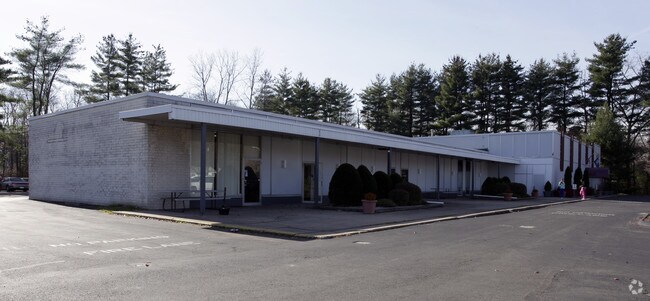
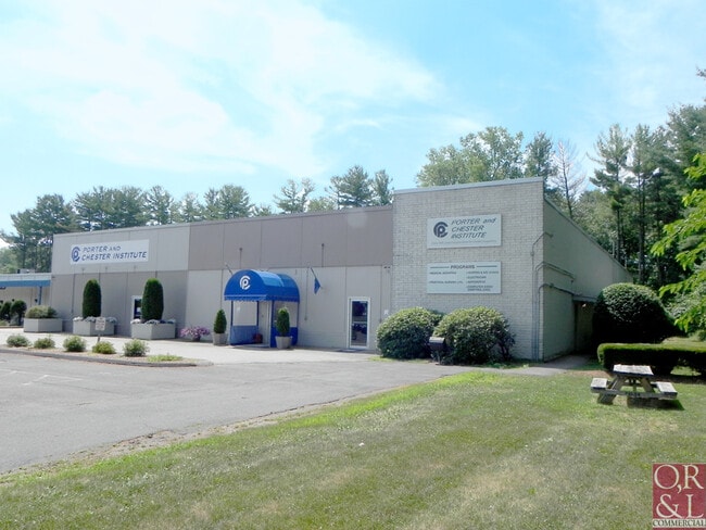
This Property Is For Sale
Current Lease Availabilities
NEARBY LISTINGS FOR SALE OR LEASE
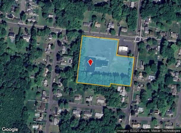
Property Detail
132 Weymouth Rd
ENFI-000052-000000-000050
Hartford
Commercialbuilding
Connecticut
X
50
09003C0229F
4.90 AC
2025
Enfield
2025
Hartford
481300
Hartford-West Hartford-East Hartford, CT
20,081 SF
DEMOGRAPHICS near 132 Weymouth Rd
1 Mile
3 Mile
5 Mile
2024 Total Population
4,593
22,997
68,542
2029 Population
4,567
22,895
68,242
Pop Growth 2024-2029
(0.57%)
(0.44%)
(0.44%)
Average Age
44
44
43
2024 Total Households
1,867
9,718
27,802
HH Growth 2024-2029
(0.59%)
(0.54%)
(0.62%)
Median Household Inc
$105,936
$87,118
$86,540
Avg Household Size
2.40
2.30
2.30
2024 Avg HH Vehicles
2.00
2.00
2.00
Median Home Value
$236,997
$234,460
$241,926
Median Year Built
1967
1967
1966
Nearby Places
- Restaurants
- Banks
- Shops
- Fitness
- Groceries
PUBLIC TRANSPORTATION
COMMUTER RAIL
Windsor Locks (Hartford Line - CT Rail (CTRail))
DRIVE
WALK
Distance
Windsor Locks (Hartford Line - CT Rail (CTRail))
10 min
5.5 mi
AIRPORT
Bradley International
DRIVE
WALK
Distance
Bradley International
26 min
10.2 mi
Freight Ports
Port of New Haven
DRIVE
WALK
Distance
Port of New Haven
72 min
53.9 mi
Nearby Properties
Address
Land Use
TOTAL SIZE
Lot Size
Zoning
Address
Land Use
TOTAL SIZE
Lot Size
Zoning
179,293 SF
51.07 AC
HR33
Address
Land Use
TOTAL SIZE
Lot Size
Zoning
201,978 SF
53.95 AC
R88
Address
Land Use
TOTAL SIZE
Lot Size
Zoning
4,418 SF
106 AC
MFDD
Address
Land Use
TOTAL SIZE
Lot Size
Zoning
32.97 AC
BR
Address
Land Use
TOTAL SIZE
Lot Size
Zoning
9,244 SF
46.83 AC
MFDD
Address
Land Use
TOTAL SIZE
Lot Size
Zoning
176,152 SF
27 AC
R44
Address
Land Use
TOTAL SIZE
Lot Size
Zoning
32.44 AC
BR
Address
Land Use
TOTAL SIZE
Lot Size
Zoning
319,054 SF
30.02 AC
I-P
Address
Land Use
TOTAL SIZE
Lot Size
Zoning
190,997 SF
18.47 AC
M-1
Address
Land Use
TOTAL SIZE
Lot Size
Zoning
277,552 SF
40.24 AC
M-1
Address
Land Use
TOTAL SIZE
Lot Size
Zoning
26.82 AC
HR33
Address
Land Use
TOTAL SIZE
Lot Size
Zoning
12.14 AC
I
Address
Land Use
TOTAL SIZE
Lot Size
Zoning
117,699 SF
6.83 AC
MFDD
Address
Land Use
TOTAL SIZE
Lot Size
Zoning
2,867 SF
17.27 AC
R-2
Address
Land Use
TOTAL SIZE
Lot Size
Zoning
24.92 AC
BL
Address
Land Use
TOTAL SIZE
Lot Size
Zoning
75,238 SF
45.70 AC
R-1
Address
Land Use
TOTAL SIZE
Lot Size
Zoning
21.50 AC
R25
Address
Land Use
TOTAL SIZE
Lot Size
Zoning
71,173 SF
14.30 AC
R-2
Address
Land Use
TOTAL SIZE
Lot Size
Zoning
13.87 AC
BR
Address
Land Use
TOTAL SIZE
Lot Size
Zoning
14,295 SF
24.45 AC
R-1
Address
Land Use
TOTAL SIZE
Lot Size
Zoning
1.87 AC
BP
Address
Land Use
TOTAL SIZE
Lot Size
Zoning
243,624 SF
12.16 AC
I
Address
Land Use
TOTAL SIZE
Lot Size
Zoning
20.54 AC
R33
Address
Land Use
TOTAL SIZE
Lot Size
Zoning
106,851 SF
20.33 AC
R25
Address
Land Use
TOTAL SIZE
Lot Size
Zoning
12 AC
HR33
Address
Land Use
TOTAL SIZE
Lot Size
Zoning
18.04 AC
R33
Address
Land Use
TOTAL SIZE
Lot Size
Zoning
21.97 AC
I-1
Address
Land Use
TOTAL SIZE
Lot Size
Zoning
214,375 SF
3.85 AC
RDRD
Address
Land Use
TOTAL SIZE
Lot Size
Zoning
7,271 SF
14.43 AC
IND2
Address
Land Use
TOTAL SIZE
Lot Size
Zoning
273,865 SF
39.41 AC
M-1
The World's #1 Commercial Real Estate Marketplace
Connect with us
© 2025 CoStar Group
The information above has been obtained from sources believed reliable. While we do not doubt its accuracy we have not verified it and make no guarantee, warranty or representation about it. It is your responsibility to independently confirm its accuracy and completeness. Any projections, opinions, assumptions, or estimates used are for example only and do not represent the current or future performance of the property. The value of this transaction to you depends on tax and other factors which should be evaluated by your tax, financial, and legal advisors. You and your advisors should conduct a careful, independent investigation of the property to determine to your satisfaction the suitability of the property for your needs.