Property Record
132 White Oak Rd, New Holland, PA 17557


NEARBY LISTINGS FOR SALE OR LEASE
Property Detail
132 White Oak Rd
190-26910-0-0000
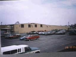
132 WHITE OAK RD
Heavyindustrial
Lancaster
X
Pennsylvania
42071C0214F
2
2024
22.20 AC
2025
Lancaster County
012900
Philadelphia
335,767 SF
Lancaster, PA
DEMOGRAPHICS near 132 White Oak Rd
1 Mile
3 Mile
5 Mile
2024 Total Population
705
15,847
28,810
2029 Population
706
15,900
28,840
Pop Growth 2024-2029
+ 0.14%
+ 0.33%
+ 0.10%
Average Age
35
41
40
2024 Total Households
202
5,839
9,959
HH Growth 2024-2029
0.00%
+ 0.51%
+ 0.21%
Median Household Inc
$60,987
$70,658
$76,833
Avg Household Size
3.30
2.60
2.80
2024 Avg HH Vehicles
2.00
2.00
2.00
Median Home Value
$267,346
$256,831
$280,296
Median Year Built
1964
1975
1976
Nearby Places
Map Layers
Map Styles
 Street
 Aerial
- Restaurants
- Banks
- Shops
- Fitness
- Groceries
Nearby Properties
Address
Land Use
TOTAL SIZE
Lot Size
Zoning
Address
Land Use
TOTAL SIZE
Lot Size
Zoning
881,497 SF
88.68 AC
R
Address
Land Use
TOTAL SIZE
Lot Size
Zoning
243,536 SF
12 AC
Address
Land Use
TOTAL SIZE
Lot Size
Zoning
273,642 SF
48.10 AC
RA
Address
Land Use
TOTAL SIZE
Lot Size
Zoning
196,406 SF
26.89 AC
R-1
Address
Land Use
TOTAL SIZE
Lot Size
Zoning
115,750 SF
35.58 AC
Address
Land Use
TOTAL SIZE
Lot Size
Zoning
678,098 SF
40.91 AC
Address
Land Use
TOTAL SIZE
Lot Size
Zoning
135,220 SF
18.64 AC
CG
Address
Land Use
TOTAL SIZE
Lot Size
Zoning
445,456 SF
29.88 AC
Address
Land Use
TOTAL SIZE
Lot Size
Zoning
117,469 SF
12.63 AC
Address
Land Use
TOTAL SIZE
Lot Size
Zoning
52,884 SF
6.81 AC
R
Address
Land Use
TOTAL SIZE
Lot Size
Zoning
137,682 SF
8.73 AC
R-2
Address
Land Use
TOTAL SIZE
Lot Size
Zoning
115,934 SF
13.48 AC
Address
Land Use
TOTAL SIZE
Lot Size
Zoning
83,852 SF
11.59 AC
I
Address
Land Use
TOTAL SIZE
Lot Size
Zoning
27,750 SF
23.20 AC
A
Address
Land Use
TOTAL SIZE
Lot Size
Zoning
35,563 SF
87.01 AC
R
Address
Land Use
TOTAL SIZE
Lot Size
Zoning
148,917 SF
9.85 AC
C-2
Address
Land Use
TOTAL SIZE
Lot Size
Zoning
109,250 SF
8.25 AC
IL
Address
Land Use
TOTAL SIZE
Lot Size
Zoning
13.10 AC
A
Address
Land Use
TOTAL SIZE
Lot Size
Zoning
44,663 SF
10.40 AC
AG
Address
Land Use
TOTAL SIZE
Lot Size
Zoning
112,160 SF
8.20 AC
M
Address
Land Use
TOTAL SIZE
Lot Size
Zoning
52,215 SF
8.91 AC
Address
Land Use
TOTAL SIZE
Lot Size
Zoning
64,363 SF
9.10 AC
C
Address
Land Use
TOTAL SIZE
Lot Size
Zoning
53,220 SF
45.60 AC
RL
Address
Land Use
TOTAL SIZE
Lot Size
Zoning
66,473 SF
4.40 AC
I
Address
Land Use
TOTAL SIZE
Lot Size
Zoning
42,438 SF
6.47 AC
I
Address
Land Use
TOTAL SIZE
Lot Size
Zoning
67,400 SF
9.50 AC
I
Address
Land Use
TOTAL SIZE
Lot Size
Zoning
117,436 SF
2 AC
C
Address
Land Use
TOTAL SIZE
Lot Size
Zoning
106,816 SF
8.50 AC
R-2
Address
Land Use
TOTAL SIZE
Lot Size
Zoning
21,077 SF
5.70 AC
CG
The World's #1 Commercial Real Estate Marketplace
Connect with us
© 2026 CoStar Group
The information above has been obtained from sources believed reliable. While we do not doubt its accuracy we have not verified it and make no guarantee, warranty or representation about it. It is your responsibility to independently confirm its accuracy and completeness. Any projections, opinions, assumptions, or estimates used are for example only and do not represent the current or future performance of the property. The value of this transaction to you depends on tax and other factors which should be evaluated by your tax, financial, and legal advisors. You and your advisors should conduct a careful, independent investigation of the property to determine to your satisfaction the suitability of the property for your needs.