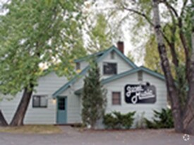
Property Record
1320 2Nd Ave E, Kalispell, MT 59901


NEARBY LISTINGS FOR SALE OR LEASE
Property Detail
1320 2Nd Ave E
07-3966-17-3-04-30-0000
S17, T28 N, R21 W, TR 5-23 IN SW4SW4, ASSR# 0000525280
Charitableorganization
Flathead
X
Montana
30029C1820J
0.51 AC
0
Glacier Country
2025
Other Market Areas
001102
Kalispell, MT
6,232 SF
DEMOGRAPHICS near 1320 2Nd Ave E
1 Mile
3 Mile
5 Mile
2024 Total Population
12,186
34,917
49,903
2029 Population
14,305
41,249
58,818
Pop Growth 2024-2029
+ 17.39%
+ 18.13%
+ 17.86%
Average Age
39
40
40
2024 Total Households
5,252
14,467
20,123
HH Growth 2024-2029
+ 17.21%
+ 18.08%
+ 17.78%
Median Household Inc
$58,980
$62,340
$65,314
Avg Household Size
2.20
2.30
2.40
2024 Avg HH Vehicles
2.00
2.00
2.00
Median Home Value
$309,282
$340,411
$361,321
Median Year Built
1977
1987
1990
Nearby Places
Map Layers
Map Styles
 Street
 Aerial
- Restaurants
- Banks
- Shops
- Fitness
- Groceries
PUBLIC TRANSPORTATION
AIRPORT
Glacier Park International
DRIVE
WALK
Distance
Glacier Park International
18 min
10.0 mi
Freight Ports
Port of Everett
DRIVE
WALK
Distance
Port of Everett
630 min
546.2 mi
SALE & LEASE HISTORY
LISTING DATE
SALE/LEASE

Feb 14, 2017
For Sale
Nearby Properties
Address
Land Use
TOTAL SIZE
Lot Size
Zoning
Address
Land Use
TOTAL SIZE
Lot Size
Zoning
800,000 SF
9.86 AC
5
Address
Land Use
TOTAL SIZE
Lot Size
Zoning
85,209 SF
3.32 AC
Address
Land Use
TOTAL SIZE
Lot Size
Zoning
321,200 SF
7.77 AC
Address
Land Use
TOTAL SIZE
Lot Size
Zoning
57,624 SF
3.73 AC
Address
Land Use
TOTAL SIZE
Lot Size
Zoning
58,248 SF
11.94 AC
5
Address
Land Use
TOTAL SIZE
Lot Size
Zoning
105,300 SF
2.56 AC
Address
Land Use
TOTAL SIZE
Lot Size
Zoning
117,819 SF
3.70 AC
Address
Land Use
TOTAL SIZE
Lot Size
Zoning
33,084 SF
5.42 AC
Address
Land Use
TOTAL SIZE
Lot Size
Zoning
97,968 SF
6.31 AC
Address
Land Use
TOTAL SIZE
Lot Size
Zoning
45,000 SF
6.79 AC
Address
Land Use
TOTAL SIZE
Lot Size
Zoning
231,514 SF
22.45 AC
6
Address
Land Use
TOTAL SIZE
Lot Size
Zoning
62,420 SF
1.73 AC
Address
Land Use
TOTAL SIZE
Lot Size
Zoning
35,198 SF
5.86 AC
Address
Land Use
TOTAL SIZE
Lot Size
Zoning
25,848 SF
2.61 AC
Address
Land Use
TOTAL SIZE
Lot Size
Zoning
83,823 SF
4.78 AC
Address
Land Use
TOTAL SIZE
Lot Size
Zoning
31,230 SF
0.64 AC
Address
Land Use
TOTAL SIZE
Lot Size
Zoning
59,195 SF
5 AC
Address
Land Use
TOTAL SIZE
Lot Size
Zoning
32,769 SF
Address
Land Use
TOTAL SIZE
Lot Size
Zoning
15,856 SF
3.64 AC
6
Address
Land Use
TOTAL SIZE
Lot Size
Zoning
69,429 SF
5.97 AC
Address
Land Use
TOTAL SIZE
Lot Size
Zoning
34,284 SF
7.37 AC
6
Address
Land Use
TOTAL SIZE
Lot Size
Zoning
34,780 SF
13.03 AC
Address
Land Use
TOTAL SIZE
Lot Size
Zoning
45,000 SF
17.54 AC
Address
Land Use
TOTAL SIZE
Lot Size
Zoning
58,563 SF
4.38 AC
Address
Land Use
TOTAL SIZE
Lot Size
Zoning
45,934 SF
2.80 AC
Address
Land Use
TOTAL SIZE
Lot Size
Zoning
47,844 SF
5.26 AC
Address
Land Use
TOTAL SIZE
Lot Size
Zoning
19,232 SF
3.79 AC
Address
Land Use
TOTAL SIZE
Lot Size
Zoning
28,492 SF
6.36 AC
1
Address
Land Use
TOTAL SIZE
Lot Size
Zoning
32,480 SF
1.73 AC
Address
Land Use
TOTAL SIZE
Lot Size
Zoning
43,560 SF
2.04 AC
3
The World's #1 Commercial Real Estate Marketplace
Connect with us
© 2026 CoStar Group
The information above has been obtained from sources believed reliable. While we do not doubt its accuracy we have not verified it and make no guarantee, warranty or representation about it. It is your responsibility to independently confirm its accuracy and completeness. Any projections, opinions, assumptions, or estimates used are for example only and do not represent the current or future performance of the property. The value of this transaction to you depends on tax and other factors which should be evaluated by your tax, financial, and legal advisors. You and your advisors should conduct a careful, independent investigation of the property to determine to your satisfaction the suitability of the property for your needs.