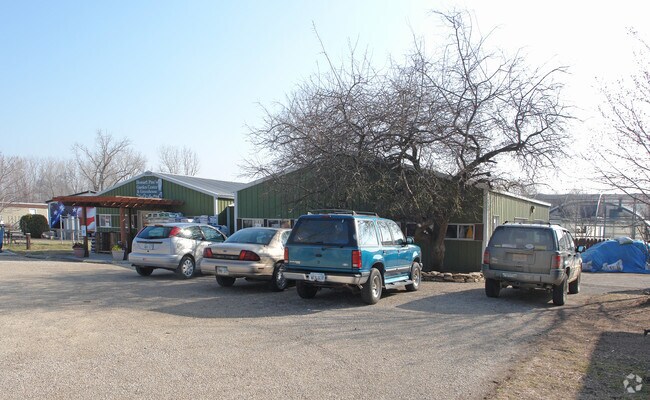
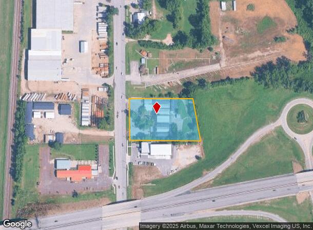
Property Record
1320 N 3Rd St, Lawrence, KS 66044
NEARBY LISTINGS FOR SALE OR LEASE
Property Detail
1320 N 3Rd St
Lawrence, KS
Subdivision 1443
023-074-19-0-10-02-010.00-0
NORTH LAWRENCE PINES ADD LT 1 2.46A
Warehouse
Douglas
AE
Kansas
20045C0176E
1
2025
4.92 AC
2025
Lawrence
000100
Kansas City
1,680 SF
DEMOGRAPHICS near 1320 N 3Rd St
1 Mile
3 Mile
5 Mile
2024 Total Population
1,410
38,288
87,503
2029 Population
1,442
39,063
89,298
Pop Growth 2024-2029
+ 2.27%
+ 2.02%
+ 2.05%
Average Age
40
34
36
2024 Total Households
560
14,770
36,628
HH Growth 2024-2029
+ 2.14%
+ 2.32%
+ 2.24%
Median Household Inc
$65,500
$51,628
$54,506
Avg Household Size
2.40
2.10
2.10
2024 Avg HH Vehicles
2.00
2.00
2.00
Median Home Value
$179,086
$219,535
$229,271
Median Year Built
1987
1975
1985
Nearby Places
Map Layers
Map Styles
 Street
 Aerial
- Restaurants
- Banks
- Shops
- Fitness
- Groceries
PUBLIC TRANSPORTATION
COMMUTER RAIL
Lawrence Amtrak Station (Southwest Chief - Amtrak)
DRIVE
WALK
Distance
Lawrence Amtrak Station (Southwest Chief - Amtrak)
4 min
2.0 mi
Freight Ports
Tulsa Port Of Catoosa
DRIVE
WALK
Distance
Tulsa Port Of Catoosa
260 min
215.4 mi
Nearby Properties
Address
Land Use
TOTAL SIZE
Lot Size
Zoning
Address
Land Use
TOTAL SIZE
Lot Size
Zoning
1,709,524 SF
32.03 AC
RD
Address
Land Use
TOTAL SIZE
Lot Size
Zoning
1,258,819 SF
106.65 AC
RD
Address
Land Use
TOTAL SIZE
Lot Size
Zoning
1,264,810 SF
129.10 AC
RD
Address
Land Use
TOTAL SIZE
Lot Size
Zoning
63,837 SF
20.79 AC
H
Address
Land Use
TOTAL SIZE
Lot Size
Zoning
335,349 SF
3.17 AC
RD
Address
Land Use
TOTAL SIZE
Lot Size
Zoning
112,168 SF
38.08 AC
RD
Address
Land Use
TOTAL SIZE
Lot Size
Zoning
200,960 SF
9.20 AC
RD
Address
Land Use
TOTAL SIZE
Lot Size
Zoning
336,701 SF
5.20 AC
RD
Address
Land Use
TOTAL SIZE
Lot Size
Zoning
112,500 SF
3.90 AC
RM1
Address
Land Use
TOTAL SIZE
Lot Size
Zoning
47,457 SF
2.58 AC
Address
Land Use
TOTAL SIZE
Lot Size
Zoning
220,557 SF
8.90 AC
RD
Address
Land Use
TOTAL SIZE
Lot Size
Zoning
162,086 SF
3 AC
RD
Address
Land Use
TOTAL SIZE
Lot Size
Zoning
67,500 SF
4.03 AC
RM1
Address
Land Use
TOTAL SIZE
Lot Size
Zoning
181,346 SF
21.40 AC
497
Address
Land Use
TOTAL SIZE
Lot Size
Zoning
186,889 SF
3.60 AC
RD
Address
Land Use
TOTAL SIZE
Lot Size
Zoning
143,467 SF
2.80 AC
RM1
Address
Land Use
TOTAL SIZE
Lot Size
Zoning
5,984 SF
142.30 AC
M2
Address
Land Use
TOTAL SIZE
Lot Size
Zoning
337,280 SF
0.60 AC
RD
Address
Land Use
TOTAL SIZE
Lot Size
Zoning
31,750 SF
0.73 AC
Address
Land Use
TOTAL SIZE
Lot Size
Zoning
34,479 SF
1.08 AC
C4
Address
Land Use
TOTAL SIZE
Lot Size
Zoning
131,625 SF
2.32 AC
C3
Address
Land Use
TOTAL SIZE
Lot Size
Zoning
2,728 SF
305 AC
RS1
Address
Land Use
TOTAL SIZE
Lot Size
Zoning
24,600 SF
8.90 AC
M3
Address
Land Use
TOTAL SIZE
Lot Size
Zoning
53,064 SF
5.79 AC
M2
Address
Land Use
TOTAL SIZE
Lot Size
Zoning
53,678 SF
9.40 AC
RS2
Address
Land Use
TOTAL SIZE
Lot Size
Zoning
54,719 SF
5.30 AC
RS2
Address
Land Use
TOTAL SIZE
Lot Size
Zoning
47,152 SF
4.16 AC
RS2
Address
Land Use
TOTAL SIZE
Lot Size
Zoning
5,506 SF
6.10 AC
Address
Land Use
TOTAL SIZE
Lot Size
Zoning
35,209 SF
4.56 AC
O1
Address
Land Use
TOTAL SIZE
Lot Size
Zoning
21,856 SF
0.86 AC
RO1
The World's #1 Commercial Real Estate Marketplace
Connect with us
© 2025 CoStar Group
The information above has been obtained from sources believed reliable. While we do not doubt its accuracy we have not verified it and make no guarantee, warranty or representation about it. It is your responsibility to independently confirm its accuracy and completeness. Any projections, opinions, assumptions, or estimates used are for example only and do not represent the current or future performance of the property. The value of this transaction to you depends on tax and other factors which should be evaluated by your tax, financial, and legal advisors. You and your advisors should conduct a careful, independent investigation of the property to determine to your satisfaction the suitability of the property for your needs.