Property Record
1320 N Bristol St, Sun Prairie, WI 53590

NEARBY LISTINGS FOR SALE OR LEASE
-
-
View all Sun Prairie listings for lease on LoopNet.com
Property Detail
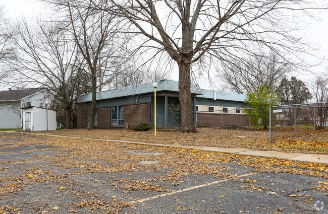
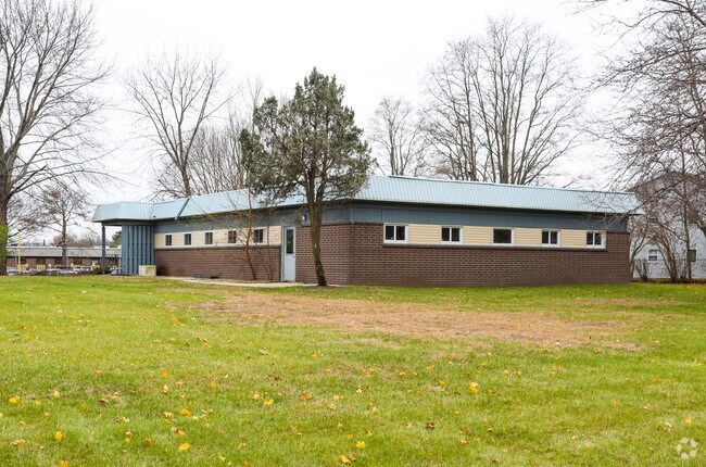
1320 N Bristol St
Madison, WI
Second Addn To Valley Subd
0911-324-8901-2
SEC 32-9-11 PRT NW1/4SE1/4 COM NW COR SECOND ADDN TO VALLEY SUBD TH E 593.98 FT TO C/L KUHLE DR TH N 330 FT TO POB TH CONT N 300 FT TH E 733 FT TO C/L CTH N TH S 300 FT TH W 732 FT TO POB EXC BEG SD POB TH N 300 FT TH E 733.2 FT TH S 7 FT T H W 142 F
Commercialnec
Dane
X
Wisconsin
55025C0279H
01
2024
1.41 AC
2024
Outlying Dane East
011508
Milwaukee/Madison
3,285 SF
DEMOGRAPHICS near 1320 N Bristol St
1 Mile
3 Mile
5 Mile
2024 Total Population
6,175
33,087
49,178
2029 Population
6,391
34,282
51,083
Pop Growth 2024-2029
+ 3.50%
+ 3.61%
+ 3.87%
Average Age
39
38
38
2024 Total Households
2,410
12,884
19,537
HH Growth 2024-2029
+ 3.61%
+ 3.77%
+ 4.05%
Median Household Inc
$79,766
$85,958
$90,419
Avg Household Size
2.50
2.50
2.50
2024 Avg HH Vehicles
2.00
2.00
2.00
Median Home Value
$287,308
$317,136
$324,058
Median Year Built
1986
1992
1996
Nearby Places
Map Layers
Map Styles
 Street
 Aerial
- Restaurants
- Banks
- Shops
- Fitness
- Groceries
PUBLIC TRANSPORTATION
AIRPORT
Dane County Regional/Truax Field
DRIVE
WALK
Distance
Dane County Regional/Truax Field
17 min
11.1 mi
Freight Ports
Port Milwaukee
DRIVE
WALK
Distance
Port Milwaukee
91 min
75.9 mi
SALE & LEASE HISTORY
LISTING DATE
SALE/LEASE

Sep 25, 2016
For Lease
Jul 05, 2017
For Lease
Nearby Properties
Address
Land Use
TOTAL SIZE
Lot Size
Zoning
Address
Land Use
TOTAL SIZE
Lot Size
Zoning
58,272 SF
136.54 AC
SO
Address
Land Use
TOTAL SIZE
Lot Size
Zoning
4.64 AC
Address
Land Use
TOTAL SIZE
Lot Size
Zoning
31,986 SF
5 AC
PD
Address
Land Use
TOTAL SIZE
Lot Size
Zoning
Address
Land Use
TOTAL SIZE
Lot Size
Zoning
Address
Land Use
TOTAL SIZE
Lot Size
Zoning
70,080 SF
3.21 AC
Address
Land Use
TOTAL SIZE
Lot Size
Zoning
26,854 SF
8.25 AC
UR12
Address
Land Use
TOTAL SIZE
Lot Size
Zoning
147,310 SF
14.68 AC
SC
Address
Land Use
TOTAL SIZE
Lot Size
Zoning
12.16 AC
Address
Land Use
TOTAL SIZE
Lot Size
Zoning
Address
Land Use
TOTAL SIZE
Lot Size
Zoning
430,172 SF
18.33 AC
SI
Address
Land Use
TOTAL SIZE
Lot Size
Zoning
22,866 SF
5.39 AC
PD
Address
Land Use
TOTAL SIZE
Lot Size
Zoning
16,464 SF
7.37 AC
UR12
Address
Land Use
TOTAL SIZE
Lot Size
Zoning
55,581 SF
3.35 AC
PD
Address
Land Use
TOTAL SIZE
Lot Size
Zoning
155,550 SF
21.13 AC
SI
Address
Land Use
TOTAL SIZE
Lot Size
Zoning
24.49 AC
Address
Land Use
TOTAL SIZE
Lot Size
Zoning
15.24 AC
ABA
Address
Land Use
TOTAL SIZE
Lot Size
Zoning
15,288 SF
14.55 AC
UR12
Address
Land Use
TOTAL SIZE
Lot Size
Zoning
20,560 SF
6.63 AC
UR12
Address
Land Use
TOTAL SIZE
Lot Size
Zoning
39,676 SF
2.57 AC
UC
Address
Land Use
TOTAL SIZE
Lot Size
Zoning
1.76 AC
Address
Land Use
TOTAL SIZE
Lot Size
Zoning
59,500 SF
8.37 AC
PD
Address
Land Use
TOTAL SIZE
Lot Size
Zoning
12.24 AC
Address
Land Use
TOTAL SIZE
Lot Size
Zoning
70,080 SF
1.90 AC
PD
Address
Land Use
TOTAL SIZE
Lot Size
Zoning
61,029 SF
6 AC
Address
Land Use
TOTAL SIZE
Lot Size
Zoning
21.09 AC
SI
Address
Land Use
TOTAL SIZE
Lot Size
Zoning
46,035 SF
1.84 AC
PD
Address
Land Use
TOTAL SIZE
Lot Size
Zoning
Address
Land Use
TOTAL SIZE
Lot Size
Zoning
26,675 SF
5.02 AC
UR12
Address
Land Use
TOTAL SIZE
Lot Size
Zoning
The World's #1 Commercial Real Estate Marketplace
Connect with us
© 2026 CoStar Group
The information above has been obtained from sources believed reliable. While we do not doubt its accuracy we have not verified it and make no guarantee, warranty or representation about it. It is your responsibility to independently confirm its accuracy and completeness. Any projections, opinions, assumptions, or estimates used are for example only and do not represent the current or future performance of the property. The value of this transaction to you depends on tax and other factors which should be evaluated by your tax, financial, and legal advisors. You and your advisors should conduct a careful, independent investigation of the property to determine to your satisfaction the suitability of the property for your needs.