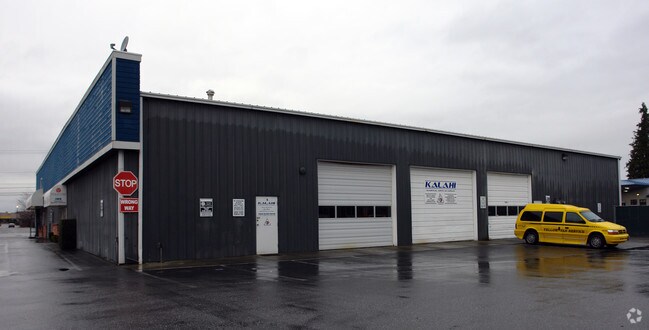
Property Record
1320 Riverside Dr, Mount Vernon, WA 98273


NEARBY LISTINGS FOR SALE OR LEASE
Property Detail
1320 Riverside Dr
Mount Vernon-Anacortes, WA
Mount Vernon Short Plat
P25990
(1.9400 AC) DK 17: TRACT A, MOUNT VERNON SHORT PLAT NO. MV-6-79, APPROVED JULY 27, 1979, AND RECORDED JULY 30, 1979 IN VOLUME 3 OF SHORT PLATS, PAGES 149 AND 150, UNDER AUDITORS FILE NO. 7907300028, BEING A PORTION OF THE SOUTH 1/2 OF THE NORTHWEST 1
Storebuilding
Skagit
2025
Washington
2025
1.94 AC
952200
Bellingham/Northwest
15,038 SF
Other Market Areas
DEMOGRAPHICS near 1320 Riverside Dr
1 Mile
3 Mile
5 Mile
2024 Total Population
7,221
47,798
59,145
2029 Population
7,486
49,933
61,699
Pop Growth 2024-2029
+ 3.67%
+ 4.47%
+ 4.32%
Average Age
38
39
40
2024 Total Households
2,824
17,626
21,799
HH Growth 2024-2029
+ 3.72%
+ 4.60%
+ 4.45%
Median Household Inc
$44,438
$60,785
$64,932
Avg Household Size
2.50
2.60
2.60
2024 Avg HH Vehicles
2.00
2.00
2.00
Median Home Value
$359,794
$402,806
$421,250
Median Year Built
1975
1987
1986
Nearby Places
Map Layers
Map Styles
 Street
 Aerial
- Restaurants
- Banks
- Shops
- Fitness
- Groceries
PUBLIC TRANSPORTATION
COMMUTER RAIL
DRIVE
WALK
Distance
4 min
1.4 mi
AIRPORT
Bellingham International
DRIVE
WALK
Distance
Bellingham International
42 min
31.6 mi
Freight Ports
DRIVE
WALK
Distance
29 min
18.0 mi
SALE & LEASE HISTORY
LISTING DATE
SALE/LEASE

Sep 24, 2016
For Sale
Dec 19, 2017
For Lease
Nearby Properties
Address
Land Use
TOTAL SIZE
Lot Size
Zoning
Address
Land Use
TOTAL SIZE
Lot Size
Zoning
404,511 SF
9.01 AC
Address
Land Use
TOTAL SIZE
Lot Size
Zoning
16,345 SF
32.99 AC
Address
Land Use
TOTAL SIZE
Lot Size
Zoning
Address
Land Use
TOTAL SIZE
Lot Size
Zoning
1,500 SF
9.93 AC
Address
Land Use
TOTAL SIZE
Lot Size
Zoning
Address
Land Use
TOTAL SIZE
Lot Size
Zoning
129,102 SF
131 SF
Address
Land Use
TOTAL SIZE
Lot Size
Zoning
77,414 SF
15.20 AC
Address
Land Use
TOTAL SIZE
Lot Size
Zoning
212,480 SF
35.36 AC
Address
Land Use
TOTAL SIZE
Lot Size
Zoning
105,000 SF
1 AC
Address
Land Use
TOTAL SIZE
Lot Size
Zoning
179,460 SF
10 AC
Address
Land Use
TOTAL SIZE
Lot Size
Zoning
96,782 SF
4.50 AC
Address
Land Use
TOTAL SIZE
Lot Size
Zoning
200,145 SF
9.35 AC
Address
Land Use
TOTAL SIZE
Lot Size
Zoning
74,608 SF
87 SF
Address
Land Use
TOTAL SIZE
Lot Size
Zoning
Address
Land Use
TOTAL SIZE
Lot Size
Zoning
0.01 AC
Address
Land Use
TOTAL SIZE
Lot Size
Zoning
138,226 SF
30.55 AC
Address
Land Use
TOTAL SIZE
Lot Size
Zoning
2,468 SF
0.68 AC
Address
Land Use
TOTAL SIZE
Lot Size
Zoning
0.01 AC
Address
Land Use
TOTAL SIZE
Lot Size
Zoning
64,668 SF
0.29 AC
Address
Land Use
TOTAL SIZE
Lot Size
Zoning
114,589 SF
10.63 AC
Address
Land Use
TOTAL SIZE
Lot Size
Zoning
52,239 SF
5.50 AC
Address
Land Use
TOTAL SIZE
Lot Size
Zoning
4,034 SF
87 SF
Address
Land Use
TOTAL SIZE
Lot Size
Zoning
0.01 AC
Address
Land Use
TOTAL SIZE
Lot Size
Zoning
138,353 SF
10 AC
Address
Land Use
TOTAL SIZE
Lot Size
Zoning
68,326 SF
5.29 AC
Address
Land Use
TOTAL SIZE
Lot Size
Zoning
75,744 SF
4 AC
Address
Land Use
TOTAL SIZE
Lot Size
Zoning
Address
Land Use
TOTAL SIZE
Lot Size
Zoning
74,419 SF
2.16 AC
Address
Land Use
TOTAL SIZE
Lot Size
Zoning
44,812 SF
6 AC
Address
Land Use
TOTAL SIZE
Lot Size
Zoning
55,326 SF
9.12 AC
The World's #1 Commercial Real Estate Marketplace
Connect with us
© 2025 CoStar Group
The information above has been obtained from sources believed reliable. While we do not doubt its accuracy we have not verified it and make no guarantee, warranty or representation about it. It is your responsibility to independently confirm its accuracy and completeness. Any projections, opinions, assumptions, or estimates used are for example only and do not represent the current or future performance of the property. The value of this transaction to you depends on tax and other factors which should be evaluated by your tax, financial, and legal advisors. You and your advisors should conduct a careful, independent investigation of the property to determine to your satisfaction the suitability of the property for your needs.