Property Record
1320 W A St, Pasco, WA 99301
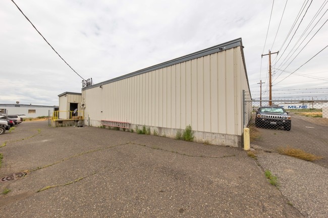
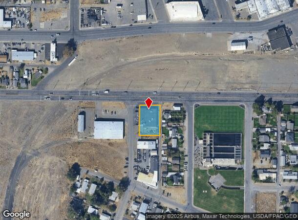
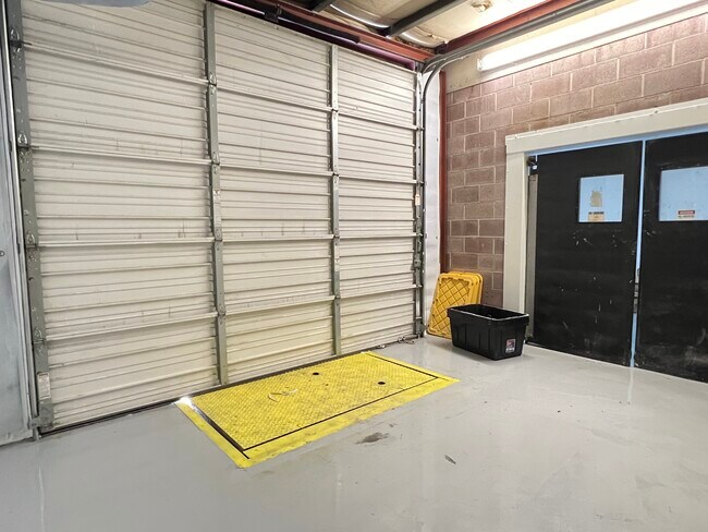
This Property Is For Sale
Current Lease Availabilities
NEARBY LISTINGS FOR SALE OR LEASE
Property Detail
1320 W A St
Other Market Areas
Riverside Add
Kennewick-Richland, WA
RIVERSIDE ADD LOTS 17 TO 20, BLK 7
112-292-074
Franklin
Commercialnec
Washington
2025
17-20
2025
0.44 AC
020401
Yakima/Kennewick
9,810 SF
DEMOGRAPHICS near 1320 W A St
1 Mile
3 Mile
5 Mile
2024 Total Population
11,709
66,987
137,997
2029 Population
12,607
72,369
148,614
Pop Growth 2024-2029
+ 7.67%
+ 8.03%
+ 7.69%
Average Age
33
34
35
2024 Total Households
3,457
21,072
45,654
HH Growth 2024-2029
+ 7.81%
+ 8.03%
+ 7.69%
Median Household Inc
$51,355
$56,448
$69,333
Avg Household Size
3.30
3.10
2.90
2024 Avg HH Vehicles
2.00
2.00
2.00
Median Home Value
$139,342
$225,670
$297,405
Median Year Built
1955
1969
1977
Nearby Places
Map Layers
Map Styles
 Street
 Aerial
- Restaurants
- Banks
- Shops
- Fitness
- Groceries
PUBLIC TRANSPORTATION
COMMUTER RAIL
Pasco Amtrak Station (Empire Builder - Amtrak)
DRIVE
WALK
Distance
Pasco Amtrak Station (Empire Builder - Amtrak)
3 min
1.5 mi
AIRPORT
Tri-Cities
DRIVE
WALK
Distance
Tri-Cities
7 min
2.9 mi
Freight Ports
Port of Tacoma
DRIVE
WALK
Distance
Port of Tacoma
274 min
238.4 mi
Nearby Properties
Address
Land Use
TOTAL SIZE
Lot Size
Zoning
Address
Land Use
TOTAL SIZE
Lot Size
Zoning
1,049,518 SF
104.40 AC
Address
Land Use
TOTAL SIZE
Lot Size
Zoning
53,980 SF
25.90 AC
Address
Land Use
TOTAL SIZE
Lot Size
Zoning
2,863,808 SF
28.33 AC
Address
Land Use
TOTAL SIZE
Lot Size
Zoning
444,084 SF
58 AC
Address
Land Use
TOTAL SIZE
Lot Size
Zoning
294,855 SF
35.04 AC
KENNEWICK
Address
Land Use
TOTAL SIZE
Lot Size
Zoning
377,541 SF
24.58 AC
Address
Land Use
TOTAL SIZE
Lot Size
Zoning
140,275 SF
6.36 AC
Address
Land Use
TOTAL SIZE
Lot Size
Zoning
153,320 SF
7.37 AC
Address
Land Use
TOTAL SIZE
Lot Size
Zoning
113,585 SF
15.43 AC
Address
Land Use
TOTAL SIZE
Lot Size
Zoning
35,284 SF
30.53 AC
Address
Land Use
TOTAL SIZE
Lot Size
Zoning
114,673 SF
6.58 AC
Address
Land Use
TOTAL SIZE
Lot Size
Zoning
84,951 SF
4.39 AC
Address
Land Use
TOTAL SIZE
Lot Size
Zoning
84,680 SF
3 AC
Address
Land Use
TOTAL SIZE
Lot Size
Zoning
61,400 SF
11.50 AC
Address
Land Use
TOTAL SIZE
Lot Size
Zoning
67,635 SF
5.95 AC
Address
Land Use
TOTAL SIZE
Lot Size
Zoning
149,281 SF
10.79 AC
Address
Land Use
TOTAL SIZE
Lot Size
Zoning
241,912 SF
12.99 AC
Address
Land Use
TOTAL SIZE
Lot Size
Zoning
110,740 SF
18.15 AC
Address
Land Use
TOTAL SIZE
Lot Size
Zoning
584,810 SF
Address
Land Use
TOTAL SIZE
Lot Size
Zoning
20,919 SF
58.49 AC
KENNEWICK
Address
Land Use
TOTAL SIZE
Lot Size
Zoning
103,115 SF
8.38 AC
Address
Land Use
TOTAL SIZE
Lot Size
Zoning
88,510 SF
14.04 AC
Address
Land Use
TOTAL SIZE
Lot Size
Zoning
47,064 SF
13.70 AC
KENNEWICK
Address
Land Use
TOTAL SIZE
Lot Size
Zoning
58,701 SF
11.34 AC
Address
Land Use
TOTAL SIZE
Lot Size
Zoning
80,604 SF
4.30 AC
Address
Land Use
TOTAL SIZE
Lot Size
Zoning
75,542 SF
6.36 AC
Address
Land Use
TOTAL SIZE
Lot Size
Zoning
125,508 SF
3.49 AC
Address
Land Use
TOTAL SIZE
Lot Size
Zoning
114,726 SF
7.59 AC
Address
Land Use
TOTAL SIZE
Lot Size
Zoning
101,720 SF
4.92 AC
33
Address
Land Use
TOTAL SIZE
Lot Size
Zoning
86,712 SF
4.15 AC
The World's #1 Commercial Real Estate Marketplace
Connect with us
© 2026 CoStar Group
The information above has been obtained from sources believed reliable. While we do not doubt its accuracy we have not verified it and make no guarantee, warranty or representation about it. It is your responsibility to independently confirm its accuracy and completeness. Any projections, opinions, assumptions, or estimates used are for example only and do not represent the current or future performance of the property. The value of this transaction to you depends on tax and other factors which should be evaluated by your tax, financial, and legal advisors. You and your advisors should conduct a careful, independent investigation of the property to determine to your satisfaction the suitability of the property for your needs.