Property Record
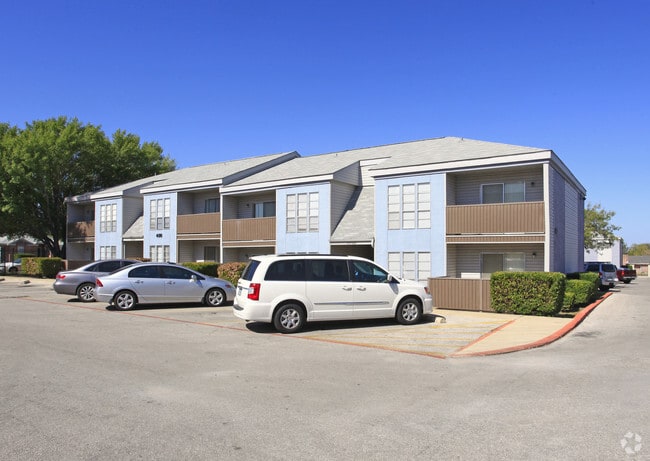
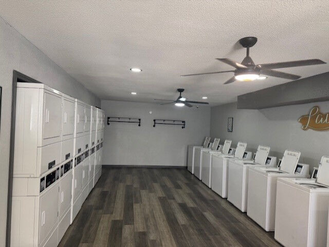
1320 Wales Dr, Killeen, TX 76549

Property Detail
1320 Wales Dr
51588
HOOD VIEW ADDITION RESUBDIVISION (LT 1 BLK 7), BLOCK 007, LOT 001A, HOODVIEW APTS & BUSINESS PERSONAL PROPERTY, ACRES 5.996
Multifamilydwelling
Bell
R-3
Texas
B and X Area of moderate flood hazard, usually the area between the limits of the 100-year and 500-year floods.
1a
2025
6 AC
2025
Killeen/Fort Hood
023113
Killeen/Temple/Fort Hood
147,727 SF
Killeen-Temple, TX
NEARBY LISTINGS FOR SALE OR LEASE
DEMOGRAPHICS near 1320 Wales Dr
1 mile
3 mile
5 mile
2025 Total Population
13,488
100,442
164,206
2030 Population
14,148
106,180
173,223
Pop Growth 2025-2030
+ 4.89%
+ 5.71%
+ 5.49%
Average Age
33
31
32
2025 Total Households
5,123
34,413
57,114
HH Growth 2025-2030
+ 5.04%
+ 6.17%
+ 5.89%
Median Household Inc
$54,039
$55,660
$58,520
Avg Household Size
2.60
2.60
2.60
2025 Avg HH Vehicles
2.00
2.00
2.00
Median Home Value
$162,724
$199,545
$207,544
Median Year Built
1985
1992
1992
Nearby Places
Map Layers
Map Styles
 Street
 Aerial
Layers
 Traffic
 Biking
Places
Listings with unknown addresses are not visible on the map
- Restaurants
- Banks
- Shops
- Fitness
- Groceries
PUBLIC TRANSPORTATION
AIRPORT
Killeen Municipal
Drive
Walk
Distance
Killeen Municipal
12 min
6.6 mi
Robert Gray AAF
Drive
Walk
Distance
Robert Gray AAF
18 min
8.5 mi
Freight Ports
Port of Houston
Drive
Walk
Distance
Port of Houston
255 min
219.0 mi
Nearby Properties
Address
Land Use
TOTAL SIZE
Lot Size
Zoning
Address
Land Use
TOTAL SIZE
Lot Size
Zoning
1 SF
13.88 AC
Address
Land Use
TOTAL SIZE
Lot Size
Zoning
1 SF
27.58 AC
Address
Land Use
TOTAL SIZE
Lot Size
Zoning
211,272 SF
18.64 AC
Address
Land Use
TOTAL SIZE
Lot Size
Zoning
234,548 SF
39.92 AC
Address
Land Use
TOTAL SIZE
Lot Size
Zoning
273,949 SF
21.92 AC
Address
Land Use
TOTAL SIZE
Lot Size
Zoning
136,782 SF
6.64 AC
Address
Land Use
TOTAL SIZE
Lot Size
Zoning
1 SF
19.23 AC
Address
Land Use
TOTAL SIZE
Lot Size
Zoning
88,836 SF
3.32 AC
Address
Land Use
TOTAL SIZE
Lot Size
Zoning
173,508 SF
8.90 AC
R-3
Address
Land Use
TOTAL SIZE
Lot Size
Zoning
1 SF
40.54 AC
Address
Land Use
TOTAL SIZE
Lot Size
Zoning
187,440 SF
54.81 AC
Address
Land Use
TOTAL SIZE
Lot Size
Zoning
46,892 SF
2.48 AC
Address
Land Use
TOTAL SIZE
Lot Size
Zoning
192,820 SF
14.26 AC
Address
Land Use
TOTAL SIZE
Lot Size
Zoning
108,964 SF
4.50 AC
Address
Land Use
TOTAL SIZE
Lot Size
Zoning
313.70 AC
Address
Land Use
TOTAL SIZE
Lot Size
Zoning
366,112 SF
44.17 AC
Address
Land Use
TOTAL SIZE
Lot Size
Zoning
201,823 SF
20.78 AC
Address
Land Use
TOTAL SIZE
Lot Size
Zoning
228,165 SF
22.43 AC
Address
Land Use
TOTAL SIZE
Lot Size
Zoning
1 SF
31.31 AC
Address
Land Use
TOTAL SIZE
Lot Size
Zoning
49,739 SF
Address
Land Use
TOTAL SIZE
Lot Size
Zoning
176,443 SF
10 AC
R-3
Address
Land Use
TOTAL SIZE
Lot Size
Zoning
1 SF
27.42 AC
Address
Land Use
TOTAL SIZE
Lot Size
Zoning
126,152 SF
8 AC
B-5
Address
Land Use
TOTAL SIZE
Lot Size
Zoning
174,898 SF
35.19 AC
Address
Land Use
TOTAL SIZE
Lot Size
Zoning
185,646 SF
10.65 AC
Address
Land Use
TOTAL SIZE
Lot Size
Zoning
1 SF
18.98 AC
Address
Land Use
TOTAL SIZE
Lot Size
Zoning
79,142 SF
2.11 AC
Address
Land Use
TOTAL SIZE
Lot Size
Zoning
132,605 SF
135.30 AC
Address
Land Use
TOTAL SIZE
Lot Size
Zoning
114,108 SF
11.31 AC
Address
Land Use
TOTAL SIZE
Lot Size
Zoning
171,242 SF
12.25 AC
The World's #1 Commercial Real Estate Marketplace
Connect with us
© 2026 CoStar Group
The information above has been obtained from sources believed reliable. While we do not doubt its accuracy we have not verified it and make no guarantee, warranty or representation about it. It is your responsibility to independently confirm its accuracy and completeness. Any projections, opinions, assumptions, or estimates used are for example only and do not represent the current or future performance of the property. The value of this transaction to you depends on tax and other factors which should be evaluated by your tax, financial, and legal advisors. You and your advisors should conduct a careful, independent investigation of the property to determine to your satisfaction the suitability of the property for your needs.