Property Record
13205 Gulf Blvd, Madeira Beach, FL 33708


Property Detail
13205 Gulf Blvd
Tampa-St. Petersburg-Clearwater, FL
MITCHELLS BEACH REVISED BLK 19, LOT 10 & PART OF LOTS 8 & 9 DESC AS BEG NE COR OF SD LOT 10 TH S37D21W 104FT ALG N SIDE OF SD LOT 10 TH S40D09E 72.55FT TH N49D58E 72.25FT TH S40D09E 19.55FT TH N49D58E 29.28FT TH N40D09W 114.75FT TO POB TOGETHER WITH
15-31-15-58320-019-0100
Pinellas
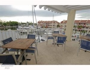
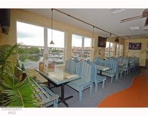
Marinafacility
Florida
AE The base floodplain where base flood elevations are provided. AE Zones are now used on new format FIRMs instead of A1-A30 Zones.
10
2024
0.44 AC
2025
South Pinellas
027802
Tampa/St Petersburg
6,724 SF
NEARBY LISTINGS FOR SALE OR LEASE
DEMOGRAPHICS near 13205 Gulf Blvd
1 mile
3 mile
5 mile
2025 Total Population
5,642
39,108
145,427
2030 Population
5,970
40,313
147,720
Pop Growth 2025-2030
+ 5.81%
+ 3.08%
+ 1.58%
Average Age
54
52
50
2025 Total Households
3,111
19,792
69,732
HH Growth 2025-2030
+ 5.69%
+ 3.24%
+ 1.74%
Median Household Inc
$87,958
$84,220
$76,432
Avg Household Size
1.80
1.90
2.00
2025 Avg HH Vehicles
2.00
2.00
2.00
Median Home Value
$738,703
$491,061
$404,761
Median Year Built
1972
1970
1971
Nearby Places
Map Layers
Map Styles
 Street
 Aerial
Layers
 Traffic
 Biking
Places
Listings with unknown addresses are not visible on the map
- Restaurants
- Banks
- Shops
- Fitness
- Groceries
PUBLIC TRANSPORTATION
AIRPORT
St Pete-Clearwater International
Drive
Walk
Distance
St Pete-Clearwater International
35 min
16.4 mi
Tampa International
Drive
Walk
Distance
Tampa International
45 min
27.1 mi
Freight Ports
Port Manatee
Drive
Walk
Distance
Port Manatee
48 min
31.0 mi
Nearby Properties
Address
Land Use
TOTAL SIZE
Lot Size
Zoning
Address
Land Use
TOTAL SIZE
Lot Size
Zoning
2,167,184 SF
297.75 AC
PSP
Address
Land Use
TOTAL SIZE
Lot Size
Zoning
453,486 SF
15.73 AC
Address
Land Use
TOTAL SIZE
Lot Size
Zoning
150,235 SF
17.90 AC
Address
Land Use
TOTAL SIZE
Lot Size
Zoning
156,994 SF
29.11 AC
Address
Land Use
TOTAL SIZE
Lot Size
Zoning
142,281 SF
1.57 AC
Address
Land Use
TOTAL SIZE
Lot Size
Zoning
29,644 SF
19.13 AC
Address
Land Use
TOTAL SIZE
Lot Size
Zoning
145,619 SF
1.68 AC
Address
Land Use
TOTAL SIZE
Lot Size
Zoning
160,086 SF
1.18 AC
Address
Land Use
TOTAL SIZE
Lot Size
Zoning
204,891 SF
18.20 AC
Address
Land Use
TOTAL SIZE
Lot Size
Zoning
4,704 SF
3.36 AC
Address
Land Use
TOTAL SIZE
Lot Size
Zoning
176,209 SF
27.52 AC
Address
Land Use
TOTAL SIZE
Lot Size
Zoning
151,421 SF
1.86 AC
Address
Land Use
TOTAL SIZE
Lot Size
Zoning
49,898 SF
77.25 AC
Address
Land Use
TOTAL SIZE
Lot Size
Zoning
119,580 SF
4.18 AC
Address
Land Use
TOTAL SIZE
Lot Size
Zoning
84,008 SF
1.49 AC
Address
Land Use
TOTAL SIZE
Lot Size
Zoning
151,149 SF
8.84 AC
RM15
Address
Land Use
TOTAL SIZE
Lot Size
Zoning
6,531 SF
357.94 AC
PC
Address
Land Use
TOTAL SIZE
Lot Size
Zoning
Address
Land Use
TOTAL SIZE
Lot Size
Zoning
132,714 SF
14.83 AC
UZ
Address
Land Use
TOTAL SIZE
Lot Size
Zoning
5,590 SF
6.38 AC
Address
Land Use
TOTAL SIZE
Lot Size
Zoning
139,181 SF
22.21 AC
R2
Address
Land Use
TOTAL SIZE
Lot Size
Zoning
57,532 SF
6.96 AC
Address
Land Use
TOTAL SIZE
Lot Size
Zoning
68,675 SF
2.07 AC
Address
Land Use
TOTAL SIZE
Lot Size
Zoning
64,888 SF
1.39 AC
Address
Land Use
TOTAL SIZE
Lot Size
Zoning
23,571 SF
55.32 AC
PSP
Address
Land Use
TOTAL SIZE
Lot Size
Zoning
26,682 SF
1.26 AC
Address
Land Use
TOTAL SIZE
Lot Size
Zoning
98,557 SF
6.92 AC
Address
Land Use
TOTAL SIZE
Lot Size
Zoning
60,996 SF
4.52 AC
Address
Land Use
TOTAL SIZE
Lot Size
Zoning
48,022 SF
3.44 AC
Address
Land Use
TOTAL SIZE
Lot Size
Zoning
71,692 SF
2.04 AC
The World's #1 Commercial Real Estate Marketplace
Connect with us
© 2026 CoStar Group
The information above has been obtained from sources believed reliable. While we do not doubt its accuracy we have not verified it and make no guarantee, warranty or representation about it. It is your responsibility to independently confirm its accuracy and completeness. Any projections, opinions, assumptions, or estimates used are for example only and do not represent the current or future performance of the property. The value of this transaction to you depends on tax and other factors which should be evaluated by your tax, financial, and legal advisors. You and your advisors should conduct a careful, independent investigation of the property to determine to your satisfaction the suitability of the property for your needs.