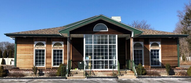
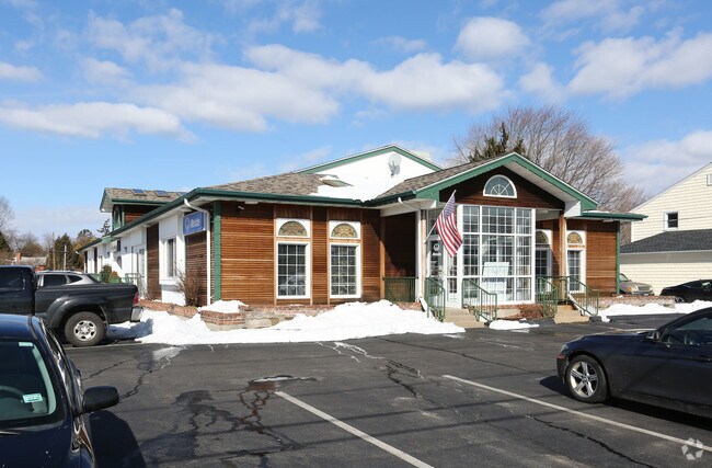
Property Record
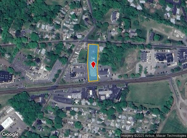
1321 Boston Post Rd, Madison, CT 06443

NEARBY LISTINGS FOR SALE OR LEASE
Property Detail
1321 Boston Post Rd
Officebuilding
New Haven
X
Connecticut
09009C0518J
0.80 AC
2025
Guilford
2025
Westchester/So Connecticut
194101
New Haven, CT
6,308 SF
MADI-000031-000000-000032
DEMOGRAPHICS near 1321 Boston Post Rd
1 Mile
3 Mile
5 Mile
2024 Total Population
1,688
18,148
30,815
2029 Population
1,732
18,367
31,214
Pop Growth 2024-2029
+ 2.61%
+ 1.21%
+ 1.29%
Average Age
50
47
47
2024 Total Households
801
7,839
13,065
HH Growth 2024-2029
+ 2.62%
+ 1.26%
+ 1.35%
Median Household Inc
$89,732
$104,367
$111,163
Avg Household Size
2.10
2.30
2.30
2024 Avg HH Vehicles
2.00
2.00
2.00
Median Home Value
$406,962
$372,363
$400,761
Median Year Built
1963
1968
1969
Nearby Places
Map Layers
Map Styles
 Street
 Aerial
- Restaurants
- Banks
- Shops
- Fitness
- Groceries
PUBLIC TRANSPORTATION
COMMUTER RAIL
Clinton (Shore Line East - Shore Line East)
DRIVE
WALK
Distance
Clinton (Shore Line East - Shore Line East)
4 min
1.4 mi
DRIVE
WALK
Distance
4 min
1.4 mi
AIRPORT
Tweed/New Haven
DRIVE
WALK
Distance
Tweed/New Haven
31 min
20.4 mi
Freight Ports
Port of New Haven
DRIVE
WALK
Distance
Port of New Haven
28 min
20.2 mi
SALE & LEASE HISTORY
LISTING DATE
SALE/LEASE

May 04, 2022
For Sale
Nearby Properties
Address
Land Use
TOTAL SIZE
Lot Size
Zoning
Address
Land Use
TOTAL SIZE
Lot Size
Zoning
47.11 AC
Address
Land Use
TOTAL SIZE
Lot Size
Zoning
138,909 SF
41.60 AC
R-20
Address
Land Use
TOTAL SIZE
Lot Size
Zoning
87,717 SF
12 AC
Address
Land Use
TOTAL SIZE
Lot Size
Zoning
22,590 SF
54.72 AC
RU-2
Address
Land Use
TOTAL SIZE
Lot Size
Zoning
98,963 SF
49.97 AC
Address
Land Use
TOTAL SIZE
Lot Size
Zoning
45,025 SF
0.93 AC
R-5
Address
Land Use
TOTAL SIZE
Lot Size
Zoning
81,335 SF
8.64 AC
B-4
Address
Land Use
TOTAL SIZE
Lot Size
Zoning
96,949 SF
11.52 AC
Address
Land Use
TOTAL SIZE
Lot Size
Zoning
540 SF
8.25 AC
C
Address
Land Use
TOTAL SIZE
Lot Size
Zoning
54,375 SF
7.01 AC
Address
Land Use
TOTAL SIZE
Lot Size
Zoning
60,070 SF
5.89 AC
DC
Address
Land Use
TOTAL SIZE
Lot Size
Zoning
37,619 SF
37.98 AC
RU-2
Address
Land Use
TOTAL SIZE
Lot Size
Zoning
15,446 SF
7.56 AC
B-2
Address
Land Use
TOTAL SIZE
Lot Size
Zoning
37,379 SF
1.43 AC
D
Address
Land Use
TOTAL SIZE
Lot Size
Zoning
822 SF
6 AC
R-2
Address
Land Use
TOTAL SIZE
Lot Size
Zoning
17,317 SF
5 AC
RU-2
Address
Land Use
TOTAL SIZE
Lot Size
Zoning
46,536 SF
3.62 AC
Address
Land Use
TOTAL SIZE
Lot Size
Zoning
56,608 SF
1.27 AC
I-1
Address
Land Use
TOTAL SIZE
Lot Size
Zoning
3,872 SF
49.73 AC
R-80
Address
Land Use
TOTAL SIZE
Lot Size
Zoning
5.56 AC
Address
Land Use
TOTAL SIZE
Lot Size
Zoning
3,077 SF
2.86 AC
T
Address
Land Use
TOTAL SIZE
Lot Size
Zoning
36,623 SF
5.13 AC
R-2
Address
Land Use
TOTAL SIZE
Lot Size
Zoning
9.32 AC
M-1
Address
Land Use
TOTAL SIZE
Lot Size
Zoning
30,922 SF
1.23 AC
C
Address
Land Use
TOTAL SIZE
Lot Size
Zoning
5,074 SF
1.30 AC
D
Address
Land Use
TOTAL SIZE
Lot Size
Zoning
640 SF
3 AC
T
Address
Land Use
TOTAL SIZE
Lot Size
Zoning
25,080 SF
2.77 AC
B-3
Address
Land Use
TOTAL SIZE
Lot Size
Zoning
13,448 SF
2.14 AC
B-4
Address
Land Use
TOTAL SIZE
Lot Size
Zoning
928 SF
2.60 AC
R-2
Address
Land Use
TOTAL SIZE
Lot Size
Zoning
27,095 SF
8.62 AC
R-2
The World's #1 Commercial Real Estate Marketplace
Connect with us
© 2026 CoStar Group
The information above has been obtained from sources believed reliable. While we do not doubt its accuracy we have not verified it and make no guarantee, warranty or representation about it. It is your responsibility to independently confirm its accuracy and completeness. Any projections, opinions, assumptions, or estimates used are for example only and do not represent the current or future performance of the property. The value of this transaction to you depends on tax and other factors which should be evaluated by your tax, financial, and legal advisors. You and your advisors should conduct a careful, independent investigation of the property to determine to your satisfaction the suitability of the property for your needs.