Property Record
13212 State Route 3, Sackets Harbor, NY 13685
NEARBY LISTINGS FOR SALE OR LEASE
-
-
View all Sackets Harbor listings for sale on LoopNet.com
Property Detail
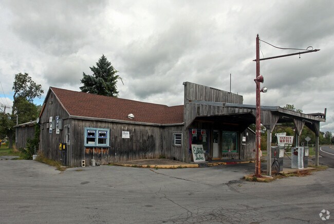
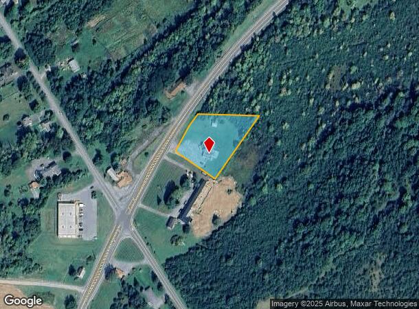
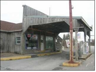
13212 State Route 3
223889-088-016-0001-086-000
PURPURA CORNERS
Restaurantbuilding
Jefferson
ARE
New York
36045C0715G
86.000
2025
1.20 AC
2024
Jefferson County
060402
Syracuse
2,080 SF
Watertown-Fort Drum, NY
DEMOGRAPHICS near 13212 State Route 3
1 Mile
3 Mile
5 Mile
2024 Total Population
196
2,207
3,616
2029 Population
193
2,180
3,588
Pop Growth 2024-2029
(1.53%)
(1.22%)
(0.77%)
Average Age
43
42
43
2024 Total Households
85
1,004
1,642
HH Growth 2024-2029
(2.35%)
(1.59%)
(1.04%)
Median Household Inc
$89,285
$78,716
$74,740
Avg Household Size
2.20
2.10
2.10
2024 Avg HH Vehicles
2.00
2.00
2.00
Median Home Value
$243,750
$255,440
$242,029
Median Year Built
1969
1973
1976
Nearby Places
- Restaurants
- Banks
- Shops
- Fitness
- Groceries
SALE & LEASE HISTORY
LISTING DATE
SALE/LEASE

Sep 24, 2016
For Sale
Apr 07, 2017
For Sale
Nearby Properties
Address
Land Use
TOTAL SIZE
Lot Size
Zoning
Address
Land Use
TOTAL SIZE
Lot Size
Zoning
4,772 SF
319.25 AC
LF
Address
Land Use
TOTAL SIZE
Lot Size
Zoning
6,150 SF
8.31 AC
Address
Land Use
TOTAL SIZE
Lot Size
Zoning
51,121 SF
24.90 AC
07 - MIXED
Address
Land Use
TOTAL SIZE
Lot Size
Zoning
13,790 SF
5.74 AC
Address
Land Use
TOTAL SIZE
Lot Size
Zoning
960 SF
3.33 AC
Address
Land Use
TOTAL SIZE
Lot Size
Zoning
4,680 SF
2.46 AC
Address
Land Use
TOTAL SIZE
Lot Size
Zoning
1,200 SF
58 AC
Address
Land Use
TOTAL SIZE
Lot Size
Zoning
4,500 SF
4.77 AC
Address
Land Use
TOTAL SIZE
Lot Size
Zoning
9,220 SF
3.57 AC
Address
Land Use
TOTAL SIZE
Lot Size
Zoning
3,060 SF
1.23 AC
Address
Land Use
TOTAL SIZE
Lot Size
Zoning
2,226 SF
62.80 AC
Address
Land Use
TOTAL SIZE
Lot Size
Zoning
Address
Land Use
TOTAL SIZE
Lot Size
Zoning
7,920 SF
2.22 AC
07 - MIXED
Address
Land Use
TOTAL SIZE
Lot Size
Zoning
15,150 SF
0.39 AC
Address
Land Use
TOTAL SIZE
Lot Size
Zoning
4,670 SF
198.20 AC
N00
Address
Land Use
TOTAL SIZE
Lot Size
Zoning
8,064 SF
1.16 AC
Address
Land Use
TOTAL SIZE
Lot Size
Zoning
14,097 SF
0.30 AC
07 - MIXED
Address
Land Use
TOTAL SIZE
Lot Size
Zoning
13,800 SF
0.96 AC
Address
Land Use
TOTAL SIZE
Lot Size
Zoning
7,715 SF
0.91 AC
07 - MIXED
Address
Land Use
TOTAL SIZE
Lot Size
Zoning
7,626 SF
3.21 AC
07 - MIXED
Address
Land Use
TOTAL SIZE
Lot Size
Zoning
13,494 SF
5 AC
07 - MIXED
Address
Land Use
TOTAL SIZE
Lot Size
Zoning
3,304 SF
261.12 AC
G00
Address
Land Use
TOTAL SIZE
Lot Size
Zoning
7,780 SF
0.58 AC
Address
Land Use
TOTAL SIZE
Lot Size
Zoning
Address
Land Use
TOTAL SIZE
Lot Size
Zoning
6,348 SF
0.90 AC
07 - MIXED
Address
Land Use
TOTAL SIZE
Lot Size
Zoning
9,642 SF
2.34 AC
Address
Land Use
TOTAL SIZE
Lot Size
Zoning
200 SF
1 AC
Address
Land Use
TOTAL SIZE
Lot Size
Zoning
Address
Land Use
TOTAL SIZE
Lot Size
Zoning
3,920 SF
0.84 AC
Address
Land Use
TOTAL SIZE
Lot Size
Zoning
19,440 SF
0.72 AC
The World's #1 Commercial Real Estate Marketplace
Connect with us
© 2025 CoStar Group
The information above has been obtained from sources believed reliable. While we do not doubt its accuracy we have not verified it and make no guarantee, warranty or representation about it. It is your responsibility to independently confirm its accuracy and completeness. Any projections, opinions, assumptions, or estimates used are for example only and do not represent the current or future performance of the property. The value of this transaction to you depends on tax and other factors which should be evaluated by your tax, financial, and legal advisors. You and your advisors should conduct a careful, independent investigation of the property to determine to your satisfaction the suitability of the property for your needs.