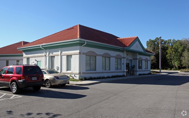
Property Record
13214 Telecom Dr, Temple Terrace, FL 33637
NEARBY LISTINGS FOR SALE OR LEASE
Property Detail
13214 Telecom Dr
Tampa-St. Petersburg-Clearwater, FL
Tampa Telecom Commercial Park Unit D
T-11-28-19-9HF-000000-D0000.0
TAMPA TELECOM COMMERCIAL PARK B-2 A CONDOMINIUM TRACT H COMMON AREA
Medicalbuilding
Hillsborough
AE
Florida
12057C0209H
h
0
0.08 AC
2025
Northeast Tampa
010810
Tampa/St Petersburg
2,928 SF
DEMOGRAPHICS near 13214 Telecom Dr
1 mile
3 mile
5 mile
2024 Total Population
8,002
75,295
192,062
2029 Population
8,661
81,801
209,471
Pop Growth 2024-2029
+ 8.24%
+ 8.64%
+ 9.06%
Average Age
35
36
36
2024 Total Households
3,509
30,999
76,031
HH Growth 2024-2029
+ 8.41%
+ 8.79%
+ 9.22%
Median Household Inc
$56,259
$47,916
$43,577
Avg Household Size
2.20
2.30
2.40
2024 Avg HH Vehicles
2.00
2.00
1.00
Median Home Value
$291,002
$276,321
$246,806
Median Year Built
1985
1986
1985
Nearby Places
Map Layers
Map Styles
 Street
 Aerial
Transit
 Traffic
 Biking
Places
Listings with unknown addresses are not visible on the map
- Restaurants
- Banks
- Shops
- Fitness
- Groceries
PUBLIC TRANSPORTATION
AIRPORT
Tampa International
Drive
Walk
Distance
Tampa International
34 min
22.5 mi
St Pete-Clearwater International
Drive
Walk
Distance
St Pete-Clearwater International
51 min
32.5 mi
Nearby Properties
Address
Land Use
TOTAL SIZE
Lot Size
Zoning
Address
Land Use
TOTAL SIZE
Lot Size
Zoning
4,011,409 SF
1,558.97 AC
UC
Address
Land Use
TOTAL SIZE
Lot Size
Zoning
727,236 SF
61.10 AC
CU
Address
Land Use
TOTAL SIZE
Lot Size
Zoning
671,677 SF
72.27 AC
RMFA
Address
Land Use
TOTAL SIZE
Lot Size
Zoning
702,607 SF
63.42 AC
PROF
Address
Land Use
TOTAL SIZE
Lot Size
Zoning
598,043 SF
47.58 AC
PD
Address
Land Use
TOTAL SIZE
Lot Size
Zoning
405,529 SF
26.81 AC
SPI-UC-1
Address
Land Use
TOTAL SIZE
Lot Size
Zoning
594,270 SF
23.02 AC
PD
Address
Land Use
TOTAL SIZE
Lot Size
Zoning
322,637 SF
18.12 AC
PD
Address
Land Use
TOTAL SIZE
Lot Size
Zoning
302,910 SF
29.81 AC
PD
Address
Land Use
TOTAL SIZE
Lot Size
Zoning
355,261 SF
22 AC
CU
Address
Land Use
TOTAL SIZE
Lot Size
Zoning
319,292 SF
31.71 AC
PD
Address
Land Use
TOTAL SIZE
Lot Size
Zoning
290,322 SF
12.51 AC
SPI-UC-1
Address
Land Use
TOTAL SIZE
Lot Size
Zoning
344,877 SF
47.21 AC
PD
Address
Land Use
TOTAL SIZE
Lot Size
Zoning
306,031 SF
16.15 AC
PD-A
Address
Land Use
TOTAL SIZE
Lot Size
Zoning
351,811 SF
70.56 AC
CU
Address
Land Use
TOTAL SIZE
Lot Size
Zoning
287,530 SF
9.09 AC
PD
Address
Land Use
TOTAL SIZE
Lot Size
Zoning
241,449 SF
9.99 AC
PD
Address
Land Use
TOTAL SIZE
Lot Size
Zoning
154,301 SF
19.82 AC
PD
Address
Land Use
TOTAL SIZE
Lot Size
Zoning
345,992 SF
20.90 AC
SPI-UC-1
Address
Land Use
TOTAL SIZE
Lot Size
Zoning
381,714 SF
4.66 AC
PD
Address
Land Use
TOTAL SIZE
Lot Size
Zoning
264,202 SF
12.86 AC
PD
Address
Land Use
TOTAL SIZE
Lot Size
Zoning
374,282 SF
13.50 AC
PD
Address
Land Use
TOTAL SIZE
Lot Size
Zoning
706,512 SF
76.54 AC
PD
Address
Land Use
TOTAL SIZE
Lot Size
Zoning
307,647 SF
4.86 AC
PD
Address
Land Use
TOTAL SIZE
Lot Size
Zoning
264,921 SF
10.14 AC
SPI-UC-1
Address
Land Use
TOTAL SIZE
Lot Size
Zoning
285,330 SF
34.74 AC
RDC-12
Address
Land Use
TOTAL SIZE
Lot Size
Zoning
207,965 SF
20.94 AC
PD-A
Address
Land Use
TOTAL SIZE
Lot Size
Zoning
485,347 SF
25.89 AC
PD-A
Address
Land Use
TOTAL SIZE
Lot Size
Zoning
381,196 SF
10.69 AC
SPI-UC-1
Address
Land Use
TOTAL SIZE
Lot Size
Zoning
251,681 SF
4.33 AC
PD
The World's #1 Commercial Real Estate Marketplace
Connect with us
© 2026 CoStar Group
The information above has been obtained from sources believed reliable. While we do not doubt its accuracy we have not verified it and make no guarantee, warranty or representation about it. It is your responsibility to independently confirm its accuracy and completeness. Any projections, opinions, assumptions, or estimates used are for example only and do not represent the current or future performance of the property. The value of this transaction to you depends on tax and other factors which should be evaluated by your tax, financial, and legal advisors. You and your advisors should conduct a careful, independent investigation of the property to determine to your satisfaction the suitability of the property for your needs.