Property Record
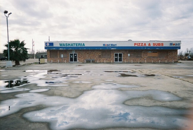
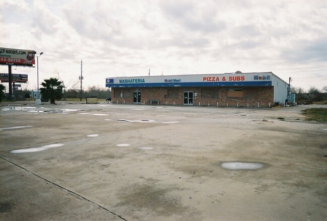
13216 Highway 6, Rosharon, TX 77583

Property Detail
13216 Highway 6
0170-00-000-5051-907
0170 M ESCALERO, BLOCK 1, ACRES 1.0348, (PT) RESERVE A, (COMMERCIAL), CHAVARRIA PLACE
Commercialnec
FORT BEND
B and X Area of moderate flood hazard, usually the area between the limits of the 100-year and 500-year floods.
Texas
2024
1.03 AC
2025
E Fort Bend Co/Sugar Land
661902
Houston
320 SF
Houston-Pasadena-The Woodlands, TX
NEARBY LISTINGS FOR SALE OR LEASE
DEMOGRAPHICS near 13216 Highway 6
1 mile
3 mile
5 mile
2025 Total Population
6,953
60,120
147,170
2030 Population
7,951
68,538
167,413
Pop Growth 2025-2030
+ 14.35%
+ 14.00%
+ 13.75%
Average Age
36
35
36
2025 Total Households
2,144
18,211
45,533
HH Growth 2025-2030
+ 14.69%
+ 14.32%
+ 14.10%
Median Household Inc
$74,259
$102,892
$118,676
Avg Household Size
3.20
3.30
3.20
2025 Avg HH Vehicles
2.00
2.00
2.00
Median Home Value
$262,403
$315,139
$366,929
Median Year Built
2005
2009
2010
Nearby Places
Map Layers
Map Styles
 Street
 Aerial
Transit
 Traffic
 Biking
Places
Listings with unknown addresses are not visible on the map
- Restaurants
- Banks
- Shops
- Fitness
- Groceries
PUBLIC TRANSPORTATION
AIRPORT
William P Hobby
Drive
Walk
Distance
William P Hobby
35 min
19.1 mi
George Bush Intcntl/Houston
Drive
Walk
Distance
George Bush Intcntl/Houston
55 min
38.5 mi
Freight Ports
Port of Houston
Drive
Walk
Distance
Port of Houston
40 min
24.0 mi
Nearby Properties
Address
Land Use
TOTAL SIZE
Lot Size
Zoning
Address
Land Use
TOTAL SIZE
Lot Size
Zoning
Address
Land Use
TOTAL SIZE
Lot Size
Zoning
344,620 SF
78.14 AC
SY
Address
Land Use
TOTAL SIZE
Lot Size
Zoning
0.08 AC
Address
Land Use
TOTAL SIZE
Lot Size
Zoning
1,764 SF
39.64 AC
ST
Address
Land Use
TOTAL SIZE
Lot Size
Zoning
Address
Land Use
TOTAL SIZE
Lot Size
Zoning
95,479 SF
10.17 AC
Address
Land Use
TOTAL SIZE
Lot Size
Zoning
82,400 SF
10.85 AC
I
Address
Land Use
TOTAL SIZE
Lot Size
Zoning
96,295 SF
12.04 AC
I
Address
Land Use
TOTAL SIZE
Lot Size
Zoning
85,092 SF
12.95 AC
Address
Land Use
TOTAL SIZE
Lot Size
Zoning
537.89 AC
Address
Land Use
TOTAL SIZE
Lot Size
Zoning
127,500 SF
7.60 AC
Address
Land Use
TOTAL SIZE
Lot Size
Zoning
105,790 SF
12.82 AC
X
Address
Land Use
TOTAL SIZE
Lot Size
Zoning
13.85 AC
Address
Land Use
TOTAL SIZE
Lot Size
Zoning
70,000 SF
64.91 AC
Address
Land Use
TOTAL SIZE
Lot Size
Zoning
Address
Land Use
TOTAL SIZE
Lot Size
Zoning
132,938 SF
29 AC
MZY
Address
Land Use
TOTAL SIZE
Lot Size
Zoning
2,000 SF
24.85 AC
Address
Land Use
TOTAL SIZE
Lot Size
Zoning
28,633 SF
9.36 AC
Address
Land Use
TOTAL SIZE
Lot Size
Zoning
224.26 AC
Address
Land Use
TOTAL SIZE
Lot Size
Zoning
4.30 AC
Address
Land Use
TOTAL SIZE
Lot Size
Zoning
17,481 SF
12.54 AC
Address
Land Use
TOTAL SIZE
Lot Size
Zoning
37,000 SF
6.06 AC
0218
Address
Land Use
TOTAL SIZE
Lot Size
Zoning
Address
Land Use
TOTAL SIZE
Lot Size
Zoning
2.92 AC
Address
Land Use
TOTAL SIZE
Lot Size
Zoning
11,400 SF
2.10 AC
Address
Land Use
TOTAL SIZE
Lot Size
Zoning
68,340 SF
3.74 AC
XS
Address
Land Use
TOTAL SIZE
Lot Size
Zoning
2.31 AC
S
Address
Land Use
TOTAL SIZE
Lot Size
Zoning
7.86 AC
SN
Address
Land Use
TOTAL SIZE
Lot Size
Zoning
Address
Land Use
TOTAL SIZE
Lot Size
Zoning
13,134 SF
2.08 AC
The World's #1 Commercial Real Estate Marketplace
Connect with us
© 2026 CoStar Group
The information above has been obtained from sources believed reliable. While we do not doubt its accuracy we have not verified it and make no guarantee, warranty or representation about it. It is your responsibility to independently confirm its accuracy and completeness. Any projections, opinions, assumptions, or estimates used are for example only and do not represent the current or future performance of the property. The value of this transaction to you depends on tax and other factors which should be evaluated by your tax, financial, and legal advisors. You and your advisors should conduct a careful, independent investigation of the property to determine to your satisfaction the suitability of the property for your needs.