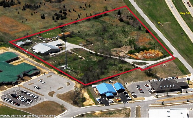
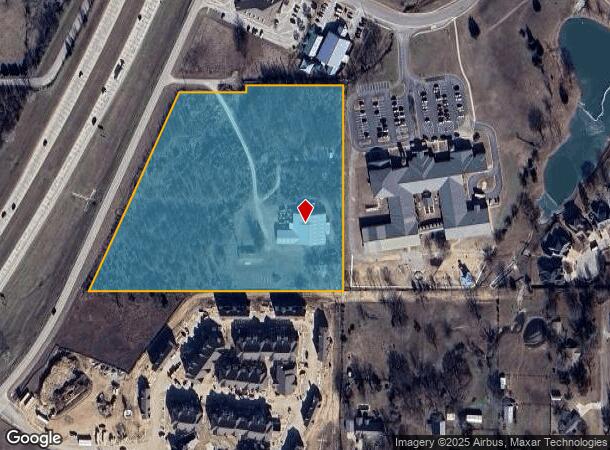
Property Record
13216 E 101St St N, Owasso, OK 74055
NEARBY LISTINGS FOR SALE OR LEASE
Property Detail
13216 E 101St St N
91416-14-16-15300
Unplatted
Residentialacreage
SE SE NW & BEG SECR E/2 SW SE NW TH W151.23 NE363.48 S330.44 POB LESS BEG NWC SE SE NW TH E151.20 SW363.41 N330.44 POB & LESS N25 E203.80 W355 SE SE NW FOR RD SEC 16 21 14 9.894ACS
X
Tulsa
40131C0250H
Oklahoma
2023
9.89 AC
2024
Northeast
005812
Tulsa
1,680 SF
Tulsa, OK
DEMOGRAPHICS near 13216 E 101St St N
1 Mile
3 Mile
5 Mile
2024 Total Population
4,132
47,064
66,577
2029 Population
4,253
49,138
69,930
Pop Growth 2024-2029
+ 2.93%
+ 4.41%
+ 5.04%
Average Age
37
38
38
2024 Total Households
1,488
17,496
24,561
HH Growth 2024-2029
+ 2.96%
+ 4.39%
+ 4.97%
Median Household Inc
$84,683
$76,626
$79,827
Avg Household Size
2.80
2.70
2.70
2024 Avg HH Vehicles
2.00
2.00
2.00
Median Home Value
$240,958
$211,749
$222,946
Median Year Built
2004
1999
1999
Nearby Places
- Restaurants
- Banks
- Shops
- Fitness
- Groceries
PUBLIC TRANSPORTATION
AIRPORT
Tulsa International
DRIVE
WALK
Distance
Tulsa International
18 min
10.1 mi
Freight Ports
DRIVE
WALK
Distance
20 min
9.6 mi
SALE & LEASE HISTORY
LISTING DATE
SALE/LEASE

Sep 01, 2017
For Sale
Nearby Properties
Address
Land Use
TOTAL SIZE
Lot Size
Zoning
Address
Land Use
TOTAL SIZE
Lot Size
Zoning
299,471 SF
64.32 AC
AG
Address
Land Use
TOTAL SIZE
Lot Size
Zoning
111,792 SF
12.43 AC
OM
Address
Land Use
TOTAL SIZE
Lot Size
Zoning
47,798 SF
5.13 AC
CS
Address
Land Use
TOTAL SIZE
Lot Size
Zoning
92,668 SF
19.30 AC
RS3
Address
Land Use
TOTAL SIZE
Lot Size
Zoning
138,427 SF
8.90 AC
OM
Address
Land Use
TOTAL SIZE
Lot Size
Zoning
105,098 SF
18.22 AC
RS2
Address
Land Use
TOTAL SIZE
Lot Size
Zoning
64,520 SF
34.28 AC
NCU
Address
Land Use
TOTAL SIZE
Lot Size
Zoning
43,882 SF
10 AC
AG
Address
Land Use
TOTAL SIZE
Lot Size
Zoning
93,712 SF
14.01 AC
RM1
Address
Land Use
TOTAL SIZE
Lot Size
Zoning
91,189 SF
10.24 AC
AG
Address
Land Use
TOTAL SIZE
Lot Size
Zoning
34,066 SF
2.88 AC
CH
Address
Land Use
TOTAL SIZE
Lot Size
Zoning
78,464 SF
10.21 AC
AG
Address
Land Use
TOTAL SIZE
Lot Size
Zoning
270,386 SF
14.65 AC
RM
Address
Land Use
TOTAL SIZE
Lot Size
Zoning
24,164 SF
11.81 AC
NCU
Address
Land Use
TOTAL SIZE
Lot Size
Zoning
31,502 SF
11.08 AC
AG
Address
Land Use
TOTAL SIZE
Lot Size
Zoning
43,252 SF
7.86 AC
RS3
Address
Land Use
TOTAL SIZE
Lot Size
Zoning
2,112 SF
10.89 AC
Address
Land Use
TOTAL SIZE
Lot Size
Zoning
17,600 SF
15.04 AC
RE
Address
Land Use
TOTAL SIZE
Lot Size
Zoning
266,778 SF
12.26 AC
CN
Address
Land Use
TOTAL SIZE
Lot Size
Zoning
226,062 SF
11.78 AC
RM2
Address
Land Use
TOTAL SIZE
Lot Size
Zoning
49,541 SF
5.28 AC
AG
Address
Land Use
TOTAL SIZE
Lot Size
Zoning
101,776 SF
9.96 AC
CS
Address
Land Use
TOTAL SIZE
Lot Size
Zoning
38,608 SF
5.07 AC
RS1
Address
Land Use
TOTAL SIZE
Lot Size
Zoning
307,768 SF
31.31 AC
RM1
Address
Land Use
TOTAL SIZE
Lot Size
Zoning
71,898 SF
3.66 AC
CS
Address
Land Use
TOTAL SIZE
Lot Size
Zoning
40,206 SF
3.72 AC
RS3
Address
Land Use
TOTAL SIZE
Lot Size
Zoning
40,822 SF
11.39 AC
AG
Address
Land Use
TOTAL SIZE
Lot Size
Zoning
42,983 SF
3.41 AC
RS3
Address
Land Use
TOTAL SIZE
Lot Size
Zoning
178,815 SF
18.21 AC
CS
Address
Land Use
TOTAL SIZE
Lot Size
Zoning
8,543 SF
1.24 AC
CS
The World's #1 Commercial Real Estate Marketplace
Connect with us
© 2025 CoStar Group
The information above has been obtained from sources believed reliable. While we do not doubt its accuracy we have not verified it and make no guarantee, warranty or representation about it. It is your responsibility to independently confirm its accuracy and completeness. Any projections, opinions, assumptions, or estimates used are for example only and do not represent the current or future performance of the property. The value of this transaction to you depends on tax and other factors which should be evaluated by your tax, financial, and legal advisors. You and your advisors should conduct a careful, independent investigation of the property to determine to your satisfaction the suitability of the property for your needs.