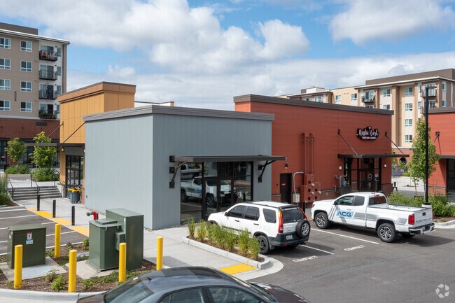
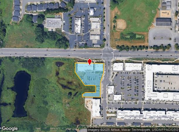
Property Record
13218 39Th Ave Se, Bothell, WA 98012
NEARBY LISTINGS FOR SALE OR LEASE
Property Detail
13218 39Th Ave Se
Seattle-Tacoma-Bellevue, WA
SECTION 33 TOWNSHIP 28 RANGE 05 QUARTER NE FARM BUILDING B-C CONDOMINIUM UNIT C TGW UND 71% INT IN COM ELEMENTS AS DESC IN DECL REC AFN 202201060283 SUBJ TO ANY AMEND THRTO PRESENTLY OF REC
012135-000-002-00
Snohomish
Commercialcondominium
Washington
2024
1.22 AC
2025
Mill Creek/Woodinville
051937
Seattle/Puget Sound
10,639 SF
DEMOGRAPHICS near 13218 39Th Ave Se
1 Mile
3 Mile
5 Mile
2024 Total Population
17,516
112,833
275,820
2029 Population
18,229
117,893
288,607
Pop Growth 2024-2029
+ 4.07%
+ 4.48%
+ 4.64%
Average Age
39
38
38
2024 Total Households
6,077
40,107
100,913
HH Growth 2024-2029
+ 4.10%
+ 4.57%
+ 4.72%
Median Household Inc
$128,993
$121,922
$102,564
Avg Household Size
2.80
2.70
2.70
2024 Avg HH Vehicles
2.00
2.00
2.00
Median Home Value
$709,633
$698,176
$664,609
Median Year Built
1999
1994
1993
Nearby Places
Map Layers
Map Styles
 Street
 Aerial
- Restaurants
- Banks
- Shops
- Fitness
- Groceries
PUBLIC TRANSPORTATION
AIRPORT
Seattle Paine Field International
DRIVE
WALK
Distance
Seattle Paine Field International
14 min
6.5 mi
Freight Ports
Port of Everett
DRIVE
WALK
Distance
Port of Everett
19 min
10.5 mi
Nearby Properties
Address
Land Use
TOTAL SIZE
Lot Size
Zoning
Address
Land Use
TOTAL SIZE
Lot Size
Zoning
375,816 SF
40.36 AC
MU/HDR
Address
Land Use
TOTAL SIZE
Lot Size
Zoning
306,149 SF
8.93 AC
MR
Address
Land Use
TOTAL SIZE
Lot Size
Zoning
33.37 AC
R-7,200
Address
Land Use
TOTAL SIZE
Lot Size
Zoning
285,554 SF
15 AC
HDR
Address
Land Use
TOTAL SIZE
Lot Size
Zoning
262,618 SF
7.05 AC
MU/HDR
Address
Land Use
TOTAL SIZE
Lot Size
Zoning
241,956 SF
20 AC
HDR
Address
Land Use
TOTAL SIZE
Lot Size
Zoning
291,349 SF
12.42 AC
MU/HDR
Address
Land Use
TOTAL SIZE
Lot Size
Zoning
57.84 AC
R-9,600
Address
Land Use
TOTAL SIZE
Lot Size
Zoning
275,336 SF
1.64 AC
UR3
Address
Land Use
TOTAL SIZE
Lot Size
Zoning
276,686 SF
17.22 AC
UR3
Address
Land Use
TOTAL SIZE
Lot Size
Zoning
864 SF
42.79 AC
LDR
Address
Land Use
TOTAL SIZE
Lot Size
Zoning
106,481 SF
27.94 AC
R-7,200
Address
Land Use
TOTAL SIZE
Lot Size
Zoning
193,938 SF
10.24 AC
UR3
Address
Land Use
TOTAL SIZE
Lot Size
Zoning
188,652 SF
8.57 AC
UR3
Address
Land Use
TOTAL SIZE
Lot Size
Zoning
180,461 SF
9.18 AC
UR3
Address
Land Use
TOTAL SIZE
Lot Size
Zoning
19,041 SF
8.17 AC
MR
Address
Land Use
TOTAL SIZE
Lot Size
Zoning
261,105 SF
50.87 AC
LDMR
Address
Land Use
TOTAL SIZE
Lot Size
Zoning
179,357 SF
10.10 AC
UR3
Address
Land Use
TOTAL SIZE
Lot Size
Zoning
172,978 SF
11.37 AC
MU
Address
Land Use
TOTAL SIZE
Lot Size
Zoning
140,946 SF
4.85 AC
UC
Address
Land Use
TOTAL SIZE
Lot Size
Zoning
131,432 SF
6.71 AC
UC
Address
Land Use
TOTAL SIZE
Lot Size
Zoning
174,489 SF
9.44 AC
UR3
Address
Land Use
TOTAL SIZE
Lot Size
Zoning
200,690 SF
6.56 AC
CB
Address
Land Use
TOTAL SIZE
Lot Size
Zoning
196,980 SF
13.42 AC
UR3
Address
Land Use
TOTAL SIZE
Lot Size
Zoning
209,724 SF
7.51 AC
MR
Address
Land Use
TOTAL SIZE
Lot Size
Zoning
136,908 SF
6.22 AC
UR3
Address
Land Use
TOTAL SIZE
Lot Size
Zoning
128,974 SF
3.88 AC
UR3
Address
Land Use
TOTAL SIZE
Lot Size
Zoning
136,966 SF
10.57 AC
HDR
Address
Land Use
TOTAL SIZE
Lot Size
Zoning
462,747 SF
1.66 AC
CB
Address
Land Use
TOTAL SIZE
Lot Size
Zoning
126,087 SF
4.59 AC
UR3
The World's #1 Commercial Real Estate Marketplace
Connect with us
© 2025 CoStar Group
The information above has been obtained from sources believed reliable. While we do not doubt its accuracy we have not verified it and make no guarantee, warranty or representation about it. It is your responsibility to independently confirm its accuracy and completeness. Any projections, opinions, assumptions, or estimates used are for example only and do not represent the current or future performance of the property. The value of this transaction to you depends on tax and other factors which should be evaluated by your tax, financial, and legal advisors. You and your advisors should conduct a careful, independent investigation of the property to determine to your satisfaction the suitability of the property for your needs.