Property Record
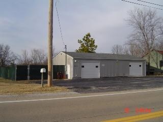
13219 State Road Cc, De Soto, MO 63020

Property Detail
13219 State Road Cc
23-2.1-03.0-0-000-011
EL PORTAL LOTS 53 54 55 56 57 & PT LOTS 51 & 52
Miscellaneous
Jefferson
CM2
Missouri
B and X Area of moderate flood hazard, usually the area between the limits of the 100-year and 500-year floods.
51-57
2024
1.37 AC
2025
Jefferson County
701403
St. Louis
1,326 SF
St. Louis, MO-IL
NEARBY LISTINGS FOR SALE OR LEASE
-
-
View all De Soto listings for sale on LoopNet.com
DEMOGRAPHICS near 13219 State Road Cc
1 mile
3 mile
5 mile
2025 Total Population
907
5,858
15,629
2030 Population
928
5,992
16,028
Pop Growth 2025-2030
+ 2.32%
+ 2.29%
+ 2.55%
Average Age
41
42
42
2025 Total Households
335
2,182
5,910
HH Growth 2025-2030
+ 2.39%
+ 2.38%
+ 2.62%
Median Household Inc
$74,999
$79,789
$79,542
Avg Household Size
2.70
2.60
2.60
2025 Avg HH Vehicles
3.00
2.00
2.00
Median Home Value
$185,647
$185,823
$209,179
Median Year Built
1989
1986
1985
Nearby Places
Map Layers
Map Styles
 Street
 Aerial
Layers
 Traffic
 Biking
Places
Listings with unknown addresses are not visible on the map
- Restaurants
- Banks
- Shops
- Fitness
- Groceries
SALE & LEASE HISTORY
LISTING DATE
SALE/LEASE

Sep 24, 2016
For Sale
Nearby Properties
Address
Land Use
TOTAL SIZE
Lot Size
Zoning
Address
Land Use
TOTAL SIZE
Lot Size
Zoning
16,074 SF
7.07 AC
CC2
Address
Land Use
TOTAL SIZE
Lot Size
Zoning
27,975 SF
6.59 AC
CC2
Address
Land Use
TOTAL SIZE
Lot Size
Zoning
2.58 AC
CC2
Address
Land Use
TOTAL SIZE
Lot Size
Zoning
14,404 SF
3.89 AC
CC2
Address
Land Use
TOTAL SIZE
Lot Size
Zoning
16,560 SF
5.06 AC
CC2
Address
Land Use
TOTAL SIZE
Lot Size
Zoning
1,176 SF
12.65 AC
NC1
Address
Land Use
TOTAL SIZE
Lot Size
Zoning
2,904 SF
0.94 AC
CC2
Address
Land Use
TOTAL SIZE
Lot Size
Zoning
4,800 SF
1.82 AC
CC2
Address
Land Use
TOTAL SIZE
Lot Size
Zoning
15,828 SF
11.62 AC
CC2
Address
Land Use
TOTAL SIZE
Lot Size
Zoning
13,646 SF
3.73 AC
CC2
Address
Land Use
TOTAL SIZE
Lot Size
Zoning
8,108 SF
6.78 AC
CC2
Address
Land Use
TOTAL SIZE
Lot Size
Zoning
4,160 SF
2.02 AC
R20
Address
Land Use
TOTAL SIZE
Lot Size
Zoning
5,040 SF
0.98 AC
CC2
Address
Land Use
TOTAL SIZE
Lot Size
Zoning
5,040 SF
0.82 AC
CC2
Address
Land Use
TOTAL SIZE
Lot Size
Zoning
4,298 SF
12.11 AC
Address
Land Use
TOTAL SIZE
Lot Size
Zoning
3,559 SF
10.06 AC
Address
Land Use
TOTAL SIZE
Lot Size
Zoning
2,840 SF
2.16 AC
CC2
Address
Land Use
TOTAL SIZE
Lot Size
Zoning
5,305 SF
100.46 AC
R40
Address
Land Use
TOTAL SIZE
Lot Size
Zoning
10,000 SF
3.50 AC
CC2
Address
Land Use
TOTAL SIZE
Lot Size
Zoning
10,596 SF
1.72 AC
R40
Address
Land Use
TOTAL SIZE
Lot Size
Zoning
2,400 SF
0.91 AC
CC2
Address
Land Use
TOTAL SIZE
Lot Size
Zoning
4,500 SF
2.98 AC
CC2
Address
Land Use
TOTAL SIZE
Lot Size
Zoning
5,663 SF
2.05 AC
Address
Land Use
TOTAL SIZE
Lot Size
Zoning
3,140 SF
5.72 AC
R20
Address
Land Use
TOTAL SIZE
Lot Size
Zoning
0.05 AC
Address
Land Use
TOTAL SIZE
Lot Size
Zoning
9,000 SF
1.78 AC
NC1
Address
Land Use
TOTAL SIZE
Lot Size
Zoning
4,481 SF
4.59 AC
R40
Address
Land Use
TOTAL SIZE
Lot Size
Zoning
3,883 SF
0.43 AC
R20
Address
Land Use
TOTAL SIZE
Lot Size
Zoning
1,064 SF
3.70 AC
CC2
Address
Land Use
TOTAL SIZE
Lot Size
Zoning
3,200 SF
1.88 AC
R20
The World's #1 Commercial Real Estate Marketplace
Connect with us
© 2026 CoStar Group
The information above has been obtained from sources believed reliable. While we do not doubt its accuracy we have not verified it and make no guarantee, warranty or representation about it. It is your responsibility to independently confirm its accuracy and completeness. Any projections, opinions, assumptions, or estimates used are for example only and do not represent the current or future performance of the property. The value of this transaction to you depends on tax and other factors which should be evaluated by your tax, financial, and legal advisors. You and your advisors should conduct a careful, independent investigation of the property to determine to your satisfaction the suitability of the property for your needs.