Property Record
1301 Aqui Esta Dr, Punta Gorda, FL 33950
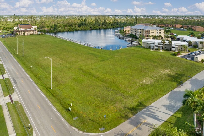

This Property Is For Sale
NEARBY LISTINGS FOR SALE OR LEASE
Property Detail
1301 Aqui Esta Dr
Punta Gorda, FL
Punta Gorda Isles
412213402001
PUNTA GORDA ISLES SEC14 BLK180 LT28 1019/319 1148/839 1912/7312072/1321 VAR2221/2112 2538/2146 2704/553 3249/756 4722/1633 PGI 014 0180 0029 PUNTA GORDA ISLES SEC14 BLK180 LT29 672/2037-38 1017/1073 1025/18412044/404 2072/1320 VAR2221/21122538/2
Residentialacreage
Charlotte
AE
Florida
12015C0241G
28
2024
3.45 AC
2025
Charlotte County
010301
Southwest Florida
DEMOGRAPHICS near 1301 Aqui Esta Dr
1 Mile
3 Mile
5 Mile
2024 Total Population
7,685
25,444
45,614
2029 Population
9,270
30,710
54,902
Pop Growth 2024-2029
+ 20.62%
+ 20.70%
+ 20.36%
Average Age
64
60
57
2024 Total Households
4,041
12,906
22,355
HH Growth 2024-2029
+ 20.81%
+ 20.84%
+ 20.63%
Median Household Inc
$72,608
$66,371
$59,890
Avg Household Size
1.90
1.90
2.00
2024 Avg HH Vehicles
2.00
2.00
2.00
Median Home Value
$459,550
$437,907
$322,772
Median Year Built
1992
1993
1990
Nearby Places
- Restaurants
- Banks
- Shops
- Fitness
- Groceries
PUBLIC TRANSPORTATION
AIRPORT
Punta Gorda
DRIVE
WALK
Distance
Punta Gorda
9 min
4.6 mi
Freight Ports
Port Manatee
DRIVE
WALK
Distance
Port Manatee
91 min
75.1 mi
Nearby Properties
Address
Land Use
TOTAL SIZE
Lot Size
Zoning
Address
Land Use
TOTAL SIZE
Lot Size
Zoning
349,844 SF
78.47 AC
P
Address
Land Use
TOTAL SIZE
Lot Size
Zoning
77,154 SF
10.30 AC
CC
Address
Land Use
TOTAL SIZE
Lot Size
Zoning
161,439 SF
171 AC
RE1
Address
Land Use
TOTAL SIZE
Lot Size
Zoning
265,949 SF
22.80 AC
PD-CC
Address
Land Use
TOTAL SIZE
Lot Size
Zoning
47,443 SF
7.94 AC
CC
Address
Land Use
TOTAL SIZE
Lot Size
Zoning
114,417 SF
4.36 AC
GM-15
Address
Land Use
TOTAL SIZE
Lot Size
Zoning
15,253 SF
13.27 AC
P
Address
Land Use
TOTAL SIZE
Lot Size
Zoning
208,560 SF
36.69 AC
PD-GM
Address
Land Use
TOTAL SIZE
Lot Size
Zoning
142,812 SF
7.89 AC
HC
Address
Land Use
TOTAL SIZE
Lot Size
Zoning
6,313 SF
15.49 AC
P
Address
Land Use
TOTAL SIZE
Lot Size
Zoning
73,095 SF
5 AC
NC
Address
Land Use
TOTAL SIZE
Lot Size
Zoning
44,185 SF
1.22 AC
CC
Address
Land Use
TOTAL SIZE
Lot Size
Zoning
25,356 SF
1.40 AC
CC
Address
Land Use
TOTAL SIZE
Lot Size
Zoning
96,845 SF
17.62 AC
HC
Address
Land Use
TOTAL SIZE
Lot Size
Zoning
82,379 SF
0.88 AC
CC
Address
Land Use
TOTAL SIZE
Lot Size
Zoning
12,159 SF
0.56 AC
CC
Address
Land Use
TOTAL SIZE
Lot Size
Zoning
24,880 SF
84.50 AC
PKR
Address
Land Use
TOTAL SIZE
Lot Size
Zoning
43,755 SF
8.19 AC
CC
Address
Land Use
TOTAL SIZE
Lot Size
Zoning
30,472 SF
3.19 AC
NR-10
Address
Land Use
TOTAL SIZE
Lot Size
Zoning
30,940 SF
0.42 AC
NC
Address
Land Use
TOTAL SIZE
Lot Size
Zoning
68,492 SF
6.38 AC
HC
Address
Land Use
TOTAL SIZE
Lot Size
Zoning
43,914 SF
4.06 AC
HC
Address
Land Use
TOTAL SIZE
Lot Size
Zoning
63,902 SF
5.87 AC
HC
Address
Land Use
TOTAL SIZE
Lot Size
Zoning
181,137 SF
12.34 AC
NR-15
Address
Land Use
TOTAL SIZE
Lot Size
Zoning
19,271 SF
3.51 AC
SP
Address
Land Use
TOTAL SIZE
Lot Size
Zoning
49,958 SF
6.81 AC
CC
Address
Land Use
TOTAL SIZE
Lot Size
Zoning
720 SF
7.40 AC
P
Address
Land Use
TOTAL SIZE
Lot Size
Zoning
104,398 SF
12.97 AC
HC
Address
Land Use
TOTAL SIZE
Lot Size
Zoning
58,195 SF
7.94 AC
NC
Address
Land Use
TOTAL SIZE
Lot Size
Zoning
2,698 SF
5.81 AC
HC
The World's #1 Commercial Real Estate Marketplace
Connect with us
© 2025 CoStar Group
The information above has been obtained from sources believed reliable. While we do not doubt its accuracy we have not verified it and make no guarantee, warranty or representation about it. It is your responsibility to independently confirm its accuracy and completeness. Any projections, opinions, assumptions, or estimates used are for example only and do not represent the current or future performance of the property. The value of this transaction to you depends on tax and other factors which should be evaluated by your tax, financial, and legal advisors. You and your advisors should conduct a careful, independent investigation of the property to determine to your satisfaction the suitability of the property for your needs.