Property Record
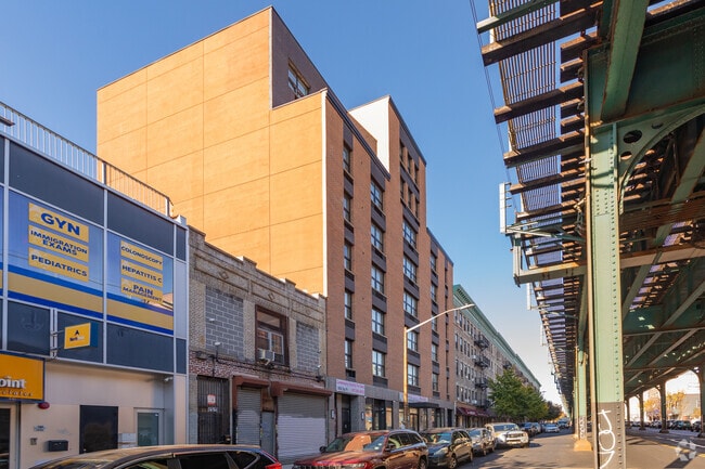
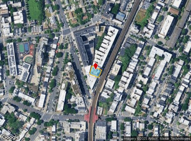
1323 Southern Blvd, Bronx, NY 10459
NEARBY LISTINGS FOR SALE OR LEASE
Property Detail
1323 Southern Blvd
02976-0098
Bronx
Apartment
New York
X
98
3604970084F
0.16 AC
2024
Fairmont
2025
Westchester/So Connecticut
012300
New York-Jersey City-White Plains, NY-NJ
42,672 SF
DEMOGRAPHICS near 1323 Southern Blvd
1 Mile
3 Mile
5 Mile
2024 Total Population
178,280
1,234,763
2,200,874
2029 Population
166,924
1,147,119
2,039,105
Pop Growth 2024-2029
(6.37%)
(7.10%)
(7.35%)
Average Age
36
38
39
2024 Total Households
60,308
439,696
836,826
HH Growth 2024-2029
(7.07%)
(7.72%)
(7.80%)
Median Household Inc
$31,977
$40,258
$50,818
Avg Household Size
2.80
2.60
2.50
2024 Avg HH Vehicles
.00
.00
.00
Median Home Value
$561,205
$514,621
$641,931
Median Year Built
1964
1950
1952
Nearby Places
- Restaurants
- Banks
- Shops
- Fitness
- Groceries
PUBLIC TRANSPORTATION
TRANSIT/SUBWAY
Freeman Street (2 - New York MTA Subway (The Subway), 5 - New York MTA Subway (The Subway))
DRIVE
WALK
Distance
Freeman Street (2 - New York MTA Subway (The Subway), 5 - New York MTA Subway (The Subway))
0 min
1 min
0.1 mi
174 Street (2 - New York MTA Subway (The Subway), 5 - New York MTA Subway (The Subway))
DRIVE
WALK
Distance
174 Street (2 - New York MTA Subway (The Subway), 5 - New York MTA Subway (The Subway))
0 min
9 min
0.5 mi
Simpson Street (2 - New York MTA Subway (The Subway), 5 - New York MTA Subway (The Subway))
DRIVE
WALK
Distance
Simpson Street (2 - New York MTA Subway (The Subway), 5 - New York MTA Subway (The Subway))
0 min
10 min
0.5 mi
Whitlock Avenue (6 - New York MTA Subway (The Subway))
DRIVE
WALK
Distance
Whitlock Avenue (6 - New York MTA Subway (The Subway))
1 min
10 min
0.5 mi
Elder Avenue (6 - New York MTA Subway (The Subway))
DRIVE
WALK
Distance
Elder Avenue (6 - New York MTA Subway (The Subway))
2 min
16 min
0.9 mi
COMMUTER RAIL
Tremont Station (Harlem Line - Metro-North Commuter Railroad Company (Metro-North))
DRIVE
WALK
Distance
Tremont Station (Harlem Line - Metro-North Commuter Railroad Company (Metro-North))
4 min
1.8 mi
Melrose Station (Harlem Line - Metro-North Commuter Railroad Company (Metro-North))
DRIVE
WALK
Distance
Melrose Station (Harlem Line - Metro-North Commuter Railroad Company (Metro-North))
5 min
1.9 mi
AIRPORT
LaGuardia
DRIVE
WALK
Distance
LaGuardia
17 min
8.3 mi
John F Kennedy International
DRIVE
WALK
Distance
John F Kennedy International
27 min
18.5 mi
Newark Liberty International
DRIVE
WALK
Distance
Newark Liberty International
29 min
24.5 mi
Freight Ports
NY - Red Hook Container Terminal
DRIVE
WALK
Distance
NY - Red Hook Container Terminal
30 min
16.5 mi
SALE & LEASE HISTORY
LISTING DATE
SALE/LEASE

May 13, 2025
For Lease
Apr 22, 2024
For Lease
Nearby Properties
Address
Land Use
TOTAL SIZE
Lot Size
Zoning
Address
Land Use
TOTAL SIZE
Lot Size
Zoning
5,519,372 SF
409.21 AC
C8-2
Address
Land Use
TOTAL SIZE
Lot Size
Zoning
3,693,539 SF
8.37 AC
R8
Address
Land Use
TOTAL SIZE
Lot Size
Zoning
1,299,700 SF
29.82 AC
R6
Address
Land Use
TOTAL SIZE
Lot Size
Zoning
1,743,584 SF
77.87 AC
R6
Address
Land Use
TOTAL SIZE
Lot Size
Zoning
2,278,432 SF
5.99 AC
R7-2
Address
Land Use
TOTAL SIZE
Lot Size
Zoning
1,427,393 SF
39.94 AC
R4
Address
Land Use
TOTAL SIZE
Lot Size
Zoning
1,651,267 SF
1.23 AC
R8
Address
Land Use
TOTAL SIZE
Lot Size
Zoning
481,172 SF
205.58 AC
PARK
Address
Land Use
TOTAL SIZE
Lot Size
Zoning
0.36 AC
R8
Address
Land Use
TOTAL SIZE
Lot Size
Zoning
891,040 SF
5.63 AC
R8
Address
Land Use
TOTAL SIZE
Lot Size
Zoning
1,311,800 SF
9.89 AC
C4-4
Address
Land Use
TOTAL SIZE
Lot Size
Zoning
23.12 AC
PARK
Address
Land Use
TOTAL SIZE
Lot Size
Zoning
1,237,424 SF
21.25 AC
R6
Address
Land Use
TOTAL SIZE
Lot Size
Zoning
1,012,000 SF
7.79 AC
R6
Address
Land Use
TOTAL SIZE
Lot Size
Zoning
807,327 SF
0.60 AC
R8
Address
Land Use
TOTAL SIZE
Lot Size
Zoning
892,550 SF
2.93 AC
M13R8
Address
Land Use
TOTAL SIZE
Lot Size
Zoning
667,405 SF
5.51 AC
R6
Address
Land Use
TOTAL SIZE
Lot Size
Zoning
2,531,670 SF
17.15 AC
R7-2
Address
Land Use
TOTAL SIZE
Lot Size
Zoning
390,750 SF
265 AC
PARK
Address
Land Use
TOTAL SIZE
Lot Size
Zoning
317,485 SF
1.57 AC
R8
Address
Land Use
TOTAL SIZE
Lot Size
Zoning
631,237 SF
30.93 AC
R5
Address
Land Use
TOTAL SIZE
Lot Size
Zoning
480,769 SF
1.21 AC
R8
Address
Land Use
TOTAL SIZE
Lot Size
Zoning
1,392,950 SF
19.67 AC
M2-1
Address
Land Use
TOTAL SIZE
Lot Size
Zoning
293,848 SF
2.98 AC
C8-3
Address
Land Use
TOTAL SIZE
Lot Size
Zoning
851,821 SF
7.95 AC
R4
Address
Land Use
TOTAL SIZE
Lot Size
Zoning
426,172 SF
14.30 AC
M3-1
Address
Land Use
TOTAL SIZE
Lot Size
Zoning
491,007 SF
11.85 AC
M3-1
Address
Land Use
TOTAL SIZE
Lot Size
Zoning
286,481 SF
0.62 AC
C6-2
Address
Land Use
TOTAL SIZE
Lot Size
Zoning
566,233 SF
13.25 AC
M3-1
Address
Land Use
TOTAL SIZE
Lot Size
Zoning
291,885 SF
8.86 AC
R8
The World's #1 Commercial Real Estate Marketplace
Connect with us
© 2025 CoStar Group
The information above has been obtained from sources believed reliable. While we do not doubt its accuracy we have not verified it and make no guarantee, warranty or representation about it. It is your responsibility to independently confirm its accuracy and completeness. Any projections, opinions, assumptions, or estimates used are for example only and do not represent the current or future performance of the property. The value of this transaction to you depends on tax and other factors which should be evaluated by your tax, financial, and legal advisors. You and your advisors should conduct a careful, independent investigation of the property to determine to your satisfaction the suitability of the property for your needs.