Property Record
13230 State Highway 31 E, Brownsboro, TX 75756
NEARBY LISTINGS FOR SALE OR LEASE
-
-
View all Brownsboro listings for lease on LoopNet.com
Property Detail
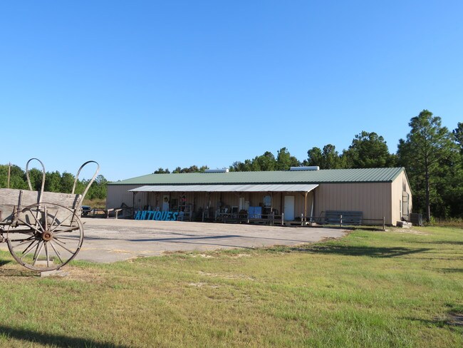
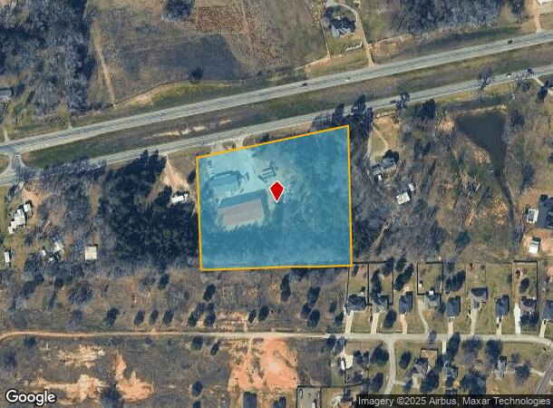
13230 State Highway 31 E
0298-0110-0000-11
C Hopfeld Sur
Commercialnec
AB 298 C HOPFELD SUR, TR 11
X
Henderson
48467C0600C
Texas
2024
5.82 AC
2025
Henderson County
950202
Dallas/Ft Worth
16,330 SF
Athens, TX
DEMOGRAPHICS near 13230 State Highway 31 E
1 Mile
3 Mile
5 Mile
2024 Total Population
578
2,312
4,149
2029 Population
604
2,403
4,315
Pop Growth 2024-2029
+ 4.50%
+ 3.94%
+ 4.00%
Average Age
40
40
41
2024 Total Households
223
892
1,599
HH Growth 2024-2029
+ 4.48%
+ 3.92%
+ 3.94%
Median Household Inc
$52,608
$54,436
$53,902
Avg Household Size
2.50
2.50
2.50
2024 Avg HH Vehicles
2.00
2.00
2.00
Median Home Value
$97,589
$116,480
$124,510
Median Year Built
1991
1991
1991
Nearby Places
Map Layers
Map Styles
 Street
 Aerial
- Restaurants
- Banks
- Shops
- Fitness
- Groceries
PUBLIC TRANSPORTATION
AIRPORT
Tyler Pounds Regional
DRIVE
WALK
Distance
Tyler Pounds Regional
26 min
18.4 mi
Freight Ports
Port of Shreveport
DRIVE
WALK
Distance
Port of Shreveport
146 min
127.2 mi
SALE & LEASE HISTORY
LISTING DATE
SALE/LEASE

May 29, 2018
For Lease
Feb 10, 2018
For Sale
Nearby Properties
Address
Land Use
TOTAL SIZE
Lot Size
Zoning
Address
Land Use
TOTAL SIZE
Lot Size
Zoning
191,055 SF
32.46 AC
Address
Land Use
TOTAL SIZE
Lot Size
Zoning
23.62 AC
Address
Land Use
TOTAL SIZE
Lot Size
Zoning
34,373 SF
1.15 AC
Address
Land Use
TOTAL SIZE
Lot Size
Zoning
7,178 SF
621.09 AC
Address
Land Use
TOTAL SIZE
Lot Size
Zoning
8,072 SF
8.50 AC
Address
Land Use
TOTAL SIZE
Lot Size
Zoning
3,723 SF
2 AC
Address
Land Use
TOTAL SIZE
Lot Size
Zoning
10.31 AC
Address
Land Use
TOTAL SIZE
Lot Size
Zoning
6,372 SF
1.30 AC
Address
Land Use
TOTAL SIZE
Lot Size
Zoning
6,479 SF
144.92 AC
Address
Land Use
TOTAL SIZE
Lot Size
Zoning
1,800 SF
38.33 AC
Address
Land Use
TOTAL SIZE
Lot Size
Zoning
9,178 SF
0.74 AC
Address
Land Use
TOTAL SIZE
Lot Size
Zoning
27,160 SF
2.50 AC
Address
Land Use
TOTAL SIZE
Lot Size
Zoning
32,984 SF
2.50 AC
Address
Land Use
TOTAL SIZE
Lot Size
Zoning
1,582 SF
101 AC
Address
Land Use
TOTAL SIZE
Lot Size
Zoning
5,261 SF
8.27 AC
Address
Land Use
TOTAL SIZE
Lot Size
Zoning
3,808 SF
27.48 AC
Address
Land Use
TOTAL SIZE
Lot Size
Zoning
7,978 SF
1 AC
Address
Land Use
TOTAL SIZE
Lot Size
Zoning
19,689 SF
1.42 AC
Address
Land Use
TOTAL SIZE
Lot Size
Zoning
20,724 SF
3.32 AC
Address
Land Use
TOTAL SIZE
Lot Size
Zoning
14,304 SF
1.51 AC
Address
Land Use
TOTAL SIZE
Lot Size
Zoning
9,600 SF
3.76 AC
Address
Land Use
TOTAL SIZE
Lot Size
Zoning
1,865 SF
85.14 AC
Address
Land Use
TOTAL SIZE
Lot Size
Zoning
5,355 SF
33.29 AC
Address
Land Use
TOTAL SIZE
Lot Size
Zoning
3,903 SF
135.25 AC
Address
Land Use
TOTAL SIZE
Lot Size
Zoning
4,715 SF
1.61 AC
Address
Land Use
TOTAL SIZE
Lot Size
Zoning
4,122 SF
1.15 AC
Address
Land Use
TOTAL SIZE
Lot Size
Zoning
10,120 SF
1.33 AC
Address
Land Use
TOTAL SIZE
Lot Size
Zoning
5,049 SF
1.88 AC
Address
Land Use
TOTAL SIZE
Lot Size
Zoning
41,914 SF
4.84 AC
The World's #1 Commercial Real Estate Marketplace
Connect with us
© 2026 CoStar Group
The information above has been obtained from sources believed reliable. While we do not doubt its accuracy we have not verified it and make no guarantee, warranty or representation about it. It is your responsibility to independently confirm its accuracy and completeness. Any projections, opinions, assumptions, or estimates used are for example only and do not represent the current or future performance of the property. The value of this transaction to you depends on tax and other factors which should be evaluated by your tax, financial, and legal advisors. You and your advisors should conduct a careful, independent investigation of the property to determine to your satisfaction the suitability of the property for your needs.