Property Record
1325 E Columbia River Hwy, Troutdale, OR 97060
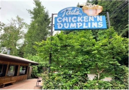
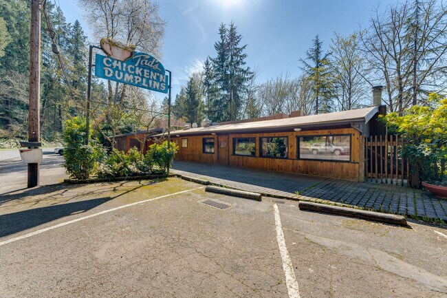

This Property Is For Sale
NEARBY LISTINGS FOR SALE OR LEASE
Property Detail
1325 E Columbia River Hwy
R322388
SECTION 30 1N 4E, TL 200 0.56 ACRES
Commercialnec
Multnomah
X
Oregon
41051C0240J
0.56 AC
2025
NE Outlying
2025
Portland
010306
Portland-Vancouver-Hillsboro, OR-WA
DEMOGRAPHICS near 1325 E Columbia River Hwy
1 Mile
3 Mile
5 Mile
2024 Total Population
3,812
37,926
133,921
2029 Population
3,672
37,002
133,663
Pop Growth 2024-2029
(3.67%)
(2.44%)
(0.19%)
Average Age
42
40
40
2024 Total Households
1,391
13,627
48,635
HH Growth 2024-2029
(4.03%)
(2.83%)
(0.41%)
Median Household Inc
$85,821
$69,367
$72,960
Avg Household Size
2.70
2.70
2.70
2024 Avg HH Vehicles
2.00
2.00
2.00
Median Home Value
$371,893
$374,362
$411,287
Median Year Built
1983
1981
1985
Nearby Places
Map Layers
Map Styles
 Street
 Aerial
- Restaurants
- Banks
- Shops
- Fitness
- Groceries
PUBLIC TRANSPORTATION
AIRPORT
Portland International
DRIVE
WALK
Distance
Portland International
23 min
14.7 mi
Freight Ports
Port of Portland
DRIVE
WALK
Distance
Port of Portland
29 min
20.2 mi
Nearby Properties
Address
Land Use
TOTAL SIZE
Lot Size
Zoning
Address
Land Use
TOTAL SIZE
Lot Size
Zoning
40.81 AC
LDR-5
Address
Land Use
TOTAL SIZE
Lot Size
Zoning
Address
Land Use
TOTAL SIZE
Lot Size
Zoning
478,472 SF
77.86 AC
GI
Address
Land Use
TOTAL SIZE
Lot Size
Zoning
302,114 SF
31.69 AC
R-5
Address
Land Use
TOTAL SIZE
Lot Size
Zoning
8.69 AC
NULL
Address
Land Use
TOTAL SIZE
Lot Size
Zoning
857,470 SF
73.72 AC
GI
Address
Land Use
TOTAL SIZE
Lot Size
Zoning
836,366 SF
38.86 AC
LI
Address
Land Use
TOTAL SIZE
Lot Size
Zoning
14,059 SF
12.83 AC
GI
Address
Land Use
TOTAL SIZE
Lot Size
Zoning
197,834 SF
8.67 AC
R5
Address
Land Use
TOTAL SIZE
Lot Size
Zoning
219,470 SF
9.77 AC
R_MF
Address
Land Use
TOTAL SIZE
Lot Size
Zoning
213,544 SF
6.64 AC
A2
Address
Land Use
TOTAL SIZE
Lot Size
Zoning
273,264 SF
11.39 AC
CMF
Address
Land Use
TOTAL SIZE
Lot Size
Zoning
156,393 SF
5.82 AC
GC
Address
Land Use
TOTAL SIZE
Lot Size
Zoning
Address
Land Use
TOTAL SIZE
Lot Size
Zoning
349,080 SF
18.69 AC
GI
Address
Land Use
TOTAL SIZE
Lot Size
Zoning
19.55 AC
GI
Address
Land Use
TOTAL SIZE
Lot Size
Zoning
65,461 SF
7.90 AC
LDR-5
Address
Land Use
TOTAL SIZE
Lot Size
Zoning
165,000 SF
14.35 AC
CC
Address
Land Use
TOTAL SIZE
Lot Size
Zoning
140,587 SF
9.73 AC
R_MF
Address
Land Use
TOTAL SIZE
Lot Size
Zoning
175,153 SF
4.90 AC
LM
Address
Land Use
TOTAL SIZE
Lot Size
Zoning
193,944 SF
11.27 AC
GI
Address
Land Use
TOTAL SIZE
Lot Size
Zoning
Address
Land Use
TOTAL SIZE
Lot Size
Zoning
4,490 SF
75.54 AC
GI
Address
Land Use
TOTAL SIZE
Lot Size
Zoning
73,073 SF
1.37 AC
R-5
Address
Land Use
TOTAL SIZE
Lot Size
Zoning
85,520 SF
14.13 AC
R-7
Address
Land Use
TOTAL SIZE
Lot Size
Zoning
136,140 SF
25.20 AC
GC
Address
Land Use
TOTAL SIZE
Lot Size
Zoning
169,778 SF
7.32 AC
A-2
Address
Land Use
TOTAL SIZE
Lot Size
Zoning
192,210 SF
18.31 AC
CI
Address
Land Use
TOTAL SIZE
Lot Size
Zoning
Address
Land Use
TOTAL SIZE
Lot Size
Zoning
145,952 SF
8.95 AC
CMF
The World's #1 Commercial Real Estate Marketplace
Connect with us
© 2026 CoStar Group
The information above has been obtained from sources believed reliable. While we do not doubt its accuracy we have not verified it and make no guarantee, warranty or representation about it. It is your responsibility to independently confirm its accuracy and completeness. Any projections, opinions, assumptions, or estimates used are for example only and do not represent the current or future performance of the property. The value of this transaction to you depends on tax and other factors which should be evaluated by your tax, financial, and legal advisors. You and your advisors should conduct a careful, independent investigation of the property to determine to your satisfaction the suitability of the property for your needs.