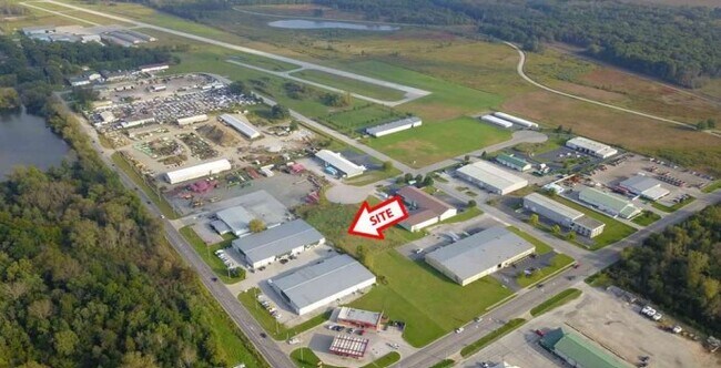
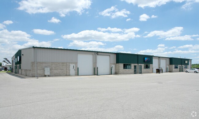
Property Record
1325 E Main St, Griffith, IN 46319
NEARBY LISTINGS FOR SALE OR LEASE
Property Detail
1325 E Main St
Chicago-Naperville-Elgin, IL-IN-WI
Gatlins Addition Phase 1
45-11-01-101-003.000-033
GATLINS ADDITION PHASE 1 LOT 2
Warehouse
Lake
X
Indiana
18089C0143E
2
2024
1.20 AC
2025
Indiana
041002
Chicago
24,336 SF
DEMOGRAPHICS near 1325 E Main St
1 Mile
3 Mile
5 Mile
2024 Total Population
3,612
47,017
168,869
2029 Population
3,623
46,857
169,817
Pop Growth 2024-2029
+ 0.30%
(0.34%)
+ 0.56%
Average Age
41
41
41
2024 Total Households
1,463
18,970
67,785
HH Growth 2024-2029
+ 0.27%
(0.37%)
+ 0.48%
Median Household Inc
$72,677
$69,361
$62,317
Avg Household Size
2.40
2.40
2.40
2024 Avg HH Vehicles
2.00
2.00
2.00
Median Home Value
$167,917
$195,260
$196,044
Median Year Built
1958
1968
1969
Nearby Places
Map Layers
Map Styles
 Street
 Aerial
- Restaurants
- Banks
- Shops
- Fitness
- Groceries
PUBLIC TRANSPORTATION
COMMUTER RAIL
DRIVE
WALK
Distance
15 min
6.0 mi
Clark Road (Gary) Station (South Shore Line - Northern Indiana Commuter Transportation District (South Shore Line))
DRIVE
WALK
Distance
Clark Road (Gary) Station (South Shore Line - Northern Indiana Commuter Transportation District (South Shore Line))
15 min
6.9 mi
AIRPORT
Chicago Midway International
DRIVE
WALK
Distance
Chicago Midway International
53 min
33.8 mi
Chicago O'Hare International
DRIVE
WALK
Distance
Chicago O'Hare International
75 min
49.6 mi
SALE & LEASE HISTORY
LISTING DATE
SALE/LEASE

Sep 25, 2016
For Lease
Dec 18, 2019
For Lease
Apr 29, 2025
For Lease
Nearby Properties
Address
Land Use
TOTAL SIZE
Lot Size
Zoning
Address
Land Use
TOTAL SIZE
Lot Size
Zoning
168,766 SF
19.16 AC
Address
Land Use
TOTAL SIZE
Lot Size
Zoning
132,147 SF
44.38 AC
R33
Address
Land Use
TOTAL SIZE
Lot Size
Zoning
105,000 SF
2.90 AC
Address
Land Use
TOTAL SIZE
Lot Size
Zoning
149,808 SF
15.07 AC
Address
Land Use
TOTAL SIZE
Lot Size
Zoning
34,116 SF
73.40 AC
Address
Land Use
TOTAL SIZE
Lot Size
Zoning
79,059 SF
7.07 AC
R3
Address
Land Use
TOTAL SIZE
Lot Size
Zoning
53,024 SF
43.30 AC
Address
Land Use
TOTAL SIZE
Lot Size
Zoning
159,134 SF
22 AC
Address
Land Use
TOTAL SIZE
Lot Size
Zoning
68.50 AC
Address
Land Use
TOTAL SIZE
Lot Size
Zoning
33,920 SF
83.34 AC
Address
Land Use
TOTAL SIZE
Lot Size
Zoning
44,960 SF
4.80 AC
Address
Land Use
TOTAL SIZE
Lot Size
Zoning
121,900 SF
8.79 AC
R3
Address
Land Use
TOTAL SIZE
Lot Size
Zoning
111,363 SF
9.60 AC
Address
Land Use
TOTAL SIZE
Lot Size
Zoning
98,658 SF
7.26 AC
R33
Address
Land Use
TOTAL SIZE
Lot Size
Zoning
14,501 SF
70.85 AC
Address
Land Use
TOTAL SIZE
Lot Size
Zoning
6,760 SF
77.37 AC
Address
Land Use
TOTAL SIZE
Lot Size
Zoning
41,406 SF
2.80 AC
R33
Address
Land Use
TOTAL SIZE
Lot Size
Zoning
38,988 SF
7.27 AC
R33
Address
Land Use
TOTAL SIZE
Lot Size
Zoning
24,964 SF
3.72 AC
Address
Land Use
TOTAL SIZE
Lot Size
Zoning
92,259 SF
6.41 AC
Address
Land Use
TOTAL SIZE
Lot Size
Zoning
105,520 SF
17.52 AC
Address
Land Use
TOTAL SIZE
Lot Size
Zoning
88,434 SF
5 AC
Address
Land Use
TOTAL SIZE
Lot Size
Zoning
163,852 SF
30.82 AC
Address
Land Use
TOTAL SIZE
Lot Size
Zoning
45,022 SF
6.02 AC
Address
Land Use
TOTAL SIZE
Lot Size
Zoning
28,674 SF
6.87 AC
Address
Land Use
TOTAL SIZE
Lot Size
Zoning
69,004 SF
12.10 AC
Address
Land Use
TOTAL SIZE
Lot Size
Zoning
40,930 SF
4.82 AC
Address
Land Use
TOTAL SIZE
Lot Size
Zoning
86,292 SF
3.84 AC
Address
Land Use
TOTAL SIZE
Lot Size
Zoning
41,172 SF
1.56 AC
Address
Land Use
TOTAL SIZE
Lot Size
Zoning
5,287 SF
47.65 AC
The World's #1 Commercial Real Estate Marketplace
Connect with us
© 2026 CoStar Group
The information above has been obtained from sources believed reliable. While we do not doubt its accuracy we have not verified it and make no guarantee, warranty or representation about it. It is your responsibility to independently confirm its accuracy and completeness. Any projections, opinions, assumptions, or estimates used are for example only and do not represent the current or future performance of the property. The value of this transaction to you depends on tax and other factors which should be evaluated by your tax, financial, and legal advisors. You and your advisors should conduct a careful, independent investigation of the property to determine to your satisfaction the suitability of the property for your needs.