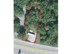
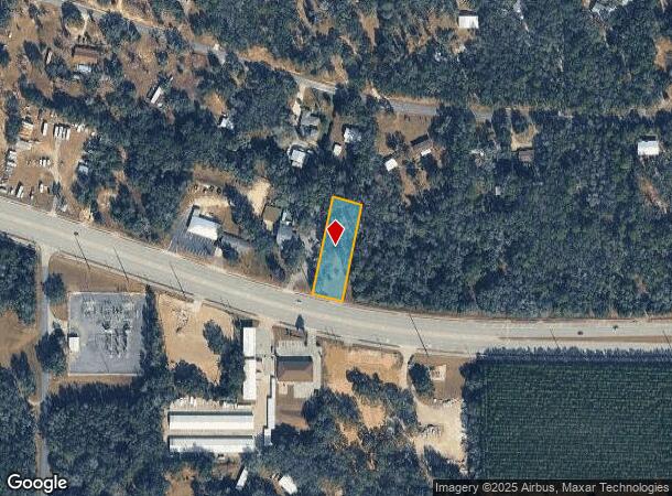
Property Record
1325 E Norvell Bryant Hwy, Hernando, FL 34442
NEARBY LISTINGS FOR SALE OR LEASE
Property Detail
1325 E Norvell Bryant Hwy
Homosassa Springs, FL
Hercala Acres Unit 2
19E-18S-27-0020-00000-0474
HERCALA ACRES UNIT NO 2 PB 8 PG 16 LT 4 OF AN UNREC SUB OF LTS 47 & 48 AND THE E 91 FT OF LT 49 DESC AS: COM AT THE SE CORNER OF N 1/2 OF NE 1/4 OF SEC 28-18-19 TH N 00DEG 08M 52S E A DIS OF 50.00 FT TO THE N R/W OF ST RD 486 TH S 89DEG 57M 06S W AL
Commercialacreage
Citrus
X
Florida
12017C0218D
4,47-
2024
0.67 AC
2025
Florida Central North Area
450104
Other Market Areas
DEMOGRAPHICS near 1325 E Norvell Bryant Hwy
1 Mile
3 Mile
5 Mile
2024 Total Population
1,781
22,845
46,701
2029 Population
2,007
25,923
53,023
Pop Growth 2024-2029
+ 12.69%
+ 13.47%
+ 13.54%
Average Age
54
54
52
2024 Total Households
795
10,449
21,229
HH Growth 2024-2029
+ 12.45%
+ 13.25%
+ 13.33%
Median Household Inc
$64,910
$53,043
$46,620
Avg Household Size
2.20
2.10
2.10
2024 Avg HH Vehicles
2.00
2.00
2.00
Median Home Value
$245,063
$233,769
$215,034
Median Year Built
1993
1992
1991
Nearby Places
Map Layers
Map Styles
 Street
 Aerial
- Restaurants
- Banks
- Shops
- Fitness
- Groceries
Nearby Properties
Address
Land Use
TOTAL SIZE
Lot Size
Zoning
Address
Land Use
TOTAL SIZE
Lot Size
Zoning
840,664 SF
6.64 AC
PDR
Address
Land Use
TOTAL SIZE
Lot Size
Zoning
114,484 SF
20.07 AC
PDR
Address
Land Use
TOTAL SIZE
Lot Size
Zoning
84,611 SF
33.22 AC
PSI
Address
Land Use
TOTAL SIZE
Lot Size
Zoning
167,220 SF
9.09 AC
GNC
Address
Land Use
TOTAL SIZE
Lot Size
Zoning
300,060 SF
8.74 AC
PDR
Address
Land Use
TOTAL SIZE
Lot Size
Zoning
135,372 SF
4.58 AC
GNC
Address
Land Use
TOTAL SIZE
Lot Size
Zoning
345,488 SF
5.87 AC
PDR
Address
Land Use
TOTAL SIZE
Lot Size
Zoning
13,025 SF
1.93 AC
PDR
Address
Land Use
TOTAL SIZE
Lot Size
Zoning
76,562 SF
212.56 AC
PDR
Address
Land Use
TOTAL SIZE
Lot Size
Zoning
67,422 SF
4.01 AC
GNC
Address
Land Use
TOTAL SIZE
Lot Size
Zoning
119,399 SF
4.77 AC
GNC
Address
Land Use
TOTAL SIZE
Lot Size
Zoning
13,577 SF
2.25 AC
PDR
Address
Land Use
TOTAL SIZE
Lot Size
Zoning
74,320 SF
4.51 AC
GNC
Address
Land Use
TOTAL SIZE
Lot Size
Zoning
16,795 SF
1.84 AC
PDR
Address
Land Use
TOTAL SIZE
Lot Size
Zoning
20,492 SF
5.02 AC
PDR
Address
Land Use
TOTAL SIZE
Lot Size
Zoning
17,496 SF
6.61 AC
PDR
Address
Land Use
TOTAL SIZE
Lot Size
Zoning
40,648 SF
4.85 AC
GNC
Address
Land Use
TOTAL SIZE
Lot Size
Zoning
18,114 SF
9.11 AC
GNC
Address
Land Use
TOTAL SIZE
Lot Size
Zoning
124,385 SF
10.16 AC
PDR
Address
Land Use
TOTAL SIZE
Lot Size
Zoning
2,088 SF
131.76 AC
PDR
Address
Land Use
TOTAL SIZE
Lot Size
Zoning
31,320 SF
5.33 AC
GNC
Address
Land Use
TOTAL SIZE
Lot Size
Zoning
151,723 SF
12.02 AC
PDR
Address
Land Use
TOTAL SIZE
Lot Size
Zoning
39,324 SF
3.48 AC
GNC
Address
Land Use
TOTAL SIZE
Lot Size
Zoning
32,361 SF
3.01 AC
GNC
Address
Land Use
TOTAL SIZE
Lot Size
Zoning
19.25 AC
PDR
Address
Land Use
TOTAL SIZE
Lot Size
Zoning
85,589 SF
6.72 AC
GNC
Address
Land Use
TOTAL SIZE
Lot Size
Zoning
42,640 SF
5.04 AC
GNC
Address
Land Use
TOTAL SIZE
Lot Size
Zoning
183,360 SF
3.42 AC
GNC
Address
Land Use
TOTAL SIZE
Lot Size
Zoning
27,692 SF
4.05 AC
PSI
Address
Land Use
TOTAL SIZE
Lot Size
Zoning
17,008 SF
5.07 AC
LDRMH
The World's #1 Commercial Real Estate Marketplace
Connect with us
© 2025 CoStar Group
The information above has been obtained from sources believed reliable. While we do not doubt its accuracy we have not verified it and make no guarantee, warranty or representation about it. It is your responsibility to independently confirm its accuracy and completeness. Any projections, opinions, assumptions, or estimates used are for example only and do not represent the current or future performance of the property. The value of this transaction to you depends on tax and other factors which should be evaluated by your tax, financial, and legal advisors. You and your advisors should conduct a careful, independent investigation of the property to determine to your satisfaction the suitability of the property for your needs.