Property Record
1325 Marietta Ave, Bellingham, WA 98226
NEARBY LISTINGS FOR SALE OR LEASE
Property Detail
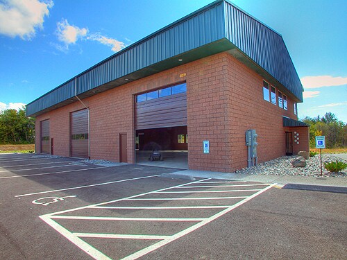
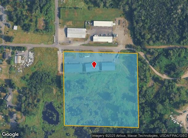
1325 Marietta Ave
Bellingham, WA
Alder Grove
380204-503032-0000
ALDER GROVE LOT 24-EXC W 30 FT TO WHATCOM CO FOR RD DESC AF 172865 VOL 115-D-510-EXC W 20 FT THEREOF
Wholesaleoutletdiscountstore
Whatcom
X
Washington
53073C1195D
24
2024
9.39 AC
2024
Bellingham/Northwest
000201
Other Market Areas
12,960 SF
DEMOGRAPHICS near 1325 Marietta Ave
1 Mile
3 Mile
5 Mile
2024 Total Population
338
19,397
57,599
2029 Population
352
20,343
60,190
Pop Growth 2024-2029
+ 4.14%
+ 4.88%
+ 4.50%
Average Age
40
41
40
2024 Total Households
122
8,395
23,930
HH Growth 2024-2029
+ 4.10%
+ 5.03%
+ 4.55%
Median Household Inc
$68,749
$57,112
$67,990
Avg Household Size
2.80
2.30
2.30
2024 Avg HH Vehicles
2.00
2.00
2.00
Median Home Value
$843,749
$468,994
$495,075
Median Year Built
2007
1995
1990
Nearby Places
- Restaurants
- Banks
- Shops
- Fitness
- Groceries
PUBLIC TRANSPORTATION
COMMUTER RAIL
Bellingham Amtrak Station (Amtrak Cascades - Amtrak)
DRIVE
WALK
Distance
Bellingham Amtrak Station (Amtrak Cascades - Amtrak)
19 min
10.0 mi
AIRPORT
Bellingham International
DRIVE
WALK
Distance
Bellingham International
10 min
4.6 mi
Abbotsford International
DRIVE
WALK
Distance
Abbotsford International
51 min
26.8 mi
Freight Ports
Port of Bellingham, WA
DRIVE
WALK
Distance
Port of Bellingham, WA
15 min
7.6 mi
SALE & LEASE HISTORY
LISTING DATE
SALE/LEASE

Jun 12, 2019
For Sale
Nearby Properties
Address
Land Use
TOTAL SIZE
Lot Size
Zoning
Address
Land Use
TOTAL SIZE
Lot Size
Zoning
112,423 SF
3.23 AC
RS
Address
Land Use
TOTAL SIZE
Lot Size
Zoning
89,174 SF
3.74 AC
PCLI
Address
Land Use
TOTAL SIZE
Lot Size
Zoning
218,295 SF
13.22 AC
PRM2.5
Address
Land Use
TOTAL SIZE
Lot Size
Zoning
239,299 SF
7.73 AC
PRM2.5
Address
Land Use
TOTAL SIZE
Lot Size
Zoning
2,059 SF
8.02 AC
RM
Address
Land Use
TOTAL SIZE
Lot Size
Zoning
95,263 SF
2.84 AC
PIN
Address
Land Use
TOTAL SIZE
Lot Size
Zoning
162,443 SF
8.01 AC
PI
Address
Land Use
TOTAL SIZE
Lot Size
Zoning
168,279 SF
2.50 AC
PCM2.5
Address
Land Use
TOTAL SIZE
Lot Size
Zoning
178,131 SF
7.42 AC
URM18
Address
Land Use
TOTAL SIZE
Lot Size
Zoning
37,698 SF
8.43 AC
GB
Address
Land Use
TOTAL SIZE
Lot Size
Zoning
166,448 SF
13.97 AC
PIC
Address
Land Use
TOTAL SIZE
Lot Size
Zoning
147,805 SF
8.92 AC
IN
Address
Land Use
TOTAL SIZE
Lot Size
Zoning
88,091 SF
4.90 AC
PICR
Address
Land Use
TOTAL SIZE
Lot Size
Zoning
104,251 SF
14.10 AC
PU
Address
Land Use
TOTAL SIZE
Lot Size
Zoning
92,026 SF
3.58 AC
RCL72B
Address
Land Use
TOTAL SIZE
Lot Size
Zoning
78,421 SF
4.92 AC
PI
Address
Land Use
TOTAL SIZE
Lot Size
Zoning
63,013 SF
3.17 AC
RCI
Address
Land Use
TOTAL SIZE
Lot Size
Zoning
149,046 SF
AO
Address
Land Use
TOTAL SIZE
Lot Size
Zoning
79,411 SF
5.26 AC
RCL72B
Address
Land Use
TOTAL SIZE
Lot Size
Zoning
83,022 SF
4.71 AC
URM18
Address
Land Use
TOTAL SIZE
Lot Size
Zoning
63,802 SF
8.93 AC
MCD
Address
Land Use
TOTAL SIZE
Lot Size
Zoning
74,027 SF
3.54 AC
RO
Address
Land Use
TOTAL SIZE
Lot Size
Zoning
147,564 SF
7.63 AC
RPC
Address
Land Use
TOTAL SIZE
Lot Size
Zoning
71,427 SF
3.22 AC
PIN
Address
Land Use
TOTAL SIZE
Lot Size
Zoning
128,509 SF
5.26 AC
RCI
Address
Land Use
TOTAL SIZE
Lot Size
Zoning
57,757 SF
19.69 AC
RCL72B
Address
Land Use
TOTAL SIZE
Lot Size
Zoning
64,509 SF
4.40 AC
GB
Address
Land Use
TOTAL SIZE
Lot Size
Zoning
59,341 SF
5.13 AC
PCRO25
Address
Land Use
TOTAL SIZE
Lot Size
Zoning
156,099 SF
11.44 AC
GB
Address
Land Use
TOTAL SIZE
Lot Size
Zoning
41,035 SF
3.82 AC
PIN
The World's #1 Commercial Real Estate Marketplace
Connect with us
© 2025 CoStar Group
The information above has been obtained from sources believed reliable. While we do not doubt its accuracy we have not verified it and make no guarantee, warranty or representation about it. It is your responsibility to independently confirm its accuracy and completeness. Any projections, opinions, assumptions, or estimates used are for example only and do not represent the current or future performance of the property. The value of this transaction to you depends on tax and other factors which should be evaluated by your tax, financial, and legal advisors. You and your advisors should conduct a careful, independent investigation of the property to determine to your satisfaction the suitability of the property for your needs.