Property Record
6012 N Lansdowne Ave, Philadelphia, PA 19151
Current Lease Availabilities
NEARBY LISTINGS FOR SALE OR LEASE
Property Detail
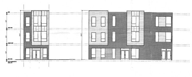
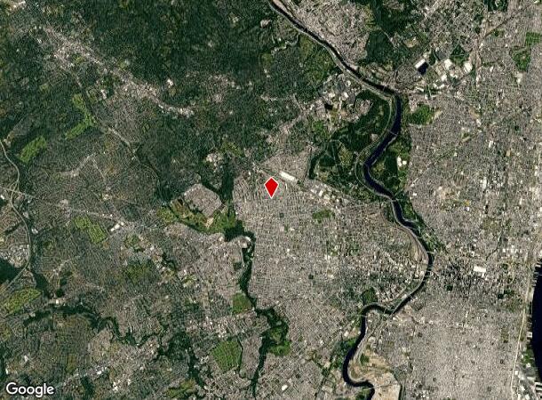
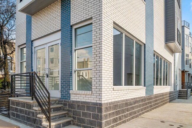
6012 N Lansdowne Ave
Philadelphia-Camden-Wilmington, PA-NJ-DE-MD
124 W 60TH ST
885000149
Philadelphia
Commercialacreage
Pennsylvania
X
234
42045C0150F
0.06 AC
2024
Northwest Philadelphia
2026
Philadelphia
010100
DEMOGRAPHICS near 6012 N Lansdowne Ave
1 Mile
3 Mile
5 Mile
2024 Total Population
91,957
503,125
1,067,506
2029 Population
91,484
495,328
1,044,767
Pop Growth 2024-2029
(0.51%)
(1.55%)
(2.13%)
Average Age
34
36
37
2024 Total Households
37,606
223,134
443,910
HH Growth 2024-2029
(0.80%)
(1.91%)
(2.38%)
Median Household Inc
$51,317
$57,552
$50,920
Avg Household Size
2.10
2.00
2.20
2024 Avg HH Vehicles
1.00
1.00
1.00
Median Home Value
$339,623
$320,412
$228,933
Median Year Built
1967
1950
1948
Nearby Places
- Restaurants
- Banks
- Shops
- Fitness
- Groceries
PUBLIC TRANSPORTATION
TRANSIT/SUBWAY
Lansdowne Avenue And 60Th Street (Route 10 - Southeastern Pennsylvania Transportation Authority Rapid Transit (SEPTA Subway & Trolley))
DRIVE
WALK
Distance
Lansdowne Avenue And 60Th Street (Route 10 - Southeastern Pennsylvania Transportation Authority Rapid Transit (SEPTA Subway & Trolley))
0 min
1 min
0.1 mi
Lansdowne Avenue And 61St Street (Route 10 - Southeastern Pennsylvania Transportation Authority Rapid Transit (SEPTA Subway & Trolley))
DRIVE
WALK
Distance
Lansdowne Avenue And 61St Street (Route 10 - Southeastern Pennsylvania Transportation Authority Rapid Transit (SEPTA Subway & Trolley))
0 min
1 min
0.1 mi
Lansdowne Avenue And 59Th Street (Route 10 - Southeastern Pennsylvania Transportation Authority Rapid Transit (SEPTA Subway & Trolley))
DRIVE
WALK
Distance
Lansdowne Avenue And 59Th Street (Route 10 - Southeastern Pennsylvania Transportation Authority Rapid Transit (SEPTA Subway & Trolley))
0 min
2 min
0.1 mi
Lansdowne Avenue And 62Nd Street (Route 10 - Southeastern Pennsylvania Transportation Authority Rapid Transit (SEPTA Subway & Trolley))
DRIVE
WALK
Distance
Lansdowne Avenue And 62Nd Street (Route 10 - Southeastern Pennsylvania Transportation Authority Rapid Transit (SEPTA Subway & Trolley))
0 min
3 min
0.2 mi
Lansdowne Avenue And 58Th Street (Route 10 - Southeastern Pennsylvania Transportation Authority Rapid Transit (SEPTA Subway & Trolley))
DRIVE
WALK
Distance
Lansdowne Avenue And 58Th Street (Route 10 - Southeastern Pennsylvania Transportation Authority Rapid Transit (SEPTA Subway & Trolley))
1 min
4 min
0.2 mi
COMMUTER RAIL
Overbrook (R5 - Southeastern Pennsylvania Transportation Authority Regional Rail (SEPTA Regional Rail))
DRIVE
WALK
Distance
Overbrook (R5 - Southeastern Pennsylvania Transportation Authority Regional Rail (SEPTA Regional Rail))
4 min
1.3 mi
Wynnefield Avenue (R6 - Southeastern Pennsylvania Transportation Authority Regional Rail (SEPTA Regional Rail))
DRIVE
WALK
Distance
Wynnefield Avenue (R6 - Southeastern Pennsylvania Transportation Authority Regional Rail (SEPTA Regional Rail))
5 min
1.8 mi
AIRPORT
Philadelphia International
DRIVE
WALK
Distance
Philadelphia International
23 min
9.3 mi
Freight Ports
South Jersey Port
DRIVE
WALK
Distance
South Jersey Port
19 min
9.0 mi
Nearby Properties
Address
Land Use
TOTAL SIZE
Lot Size
Zoning
Address
Land Use
TOTAL SIZE
Lot Size
Zoning
26,690 SF
500 AC
SPINS
Address
Land Use
TOTAL SIZE
Lot Size
Zoning
696,920 SF
10.55 AC
SPINS
Address
Land Use
TOTAL SIZE
Lot Size
Zoning
391,440 SF
1.72 AC
SPINS
Address
Land Use
TOTAL SIZE
Lot Size
Zoning
376,874 SF
3.14 AC
SPINS
Address
Land Use
TOTAL SIZE
Lot Size
Zoning
373,040 SF
4.17 AC
SPINS
Address
Land Use
TOTAL SIZE
Lot Size
Zoning
391,885 SF
7.15 AC
RM4
Address
Land Use
TOTAL SIZE
Lot Size
Zoning
303,750 SF
1.36 AC
SPINS
Address
Land Use
TOTAL SIZE
Lot Size
Zoning
552,275 SF
1 AC
CMX3
Address
Land Use
TOTAL SIZE
Lot Size
Zoning
239,760 SF
5.51 AC
SPINS
Address
Land Use
TOTAL SIZE
Lot Size
Zoning
2,178,860 SF
48.65 AC
R3
Address
Land Use
TOTAL SIZE
Lot Size
Zoning
473,400 SF
0.86 AC
CMX4
Address
Land Use
TOTAL SIZE
Lot Size
Zoning
Address
Land Use
TOTAL SIZE
Lot Size
Zoning
Address
Land Use
TOTAL SIZE
Lot Size
Zoning
354,372 SF
1 AC
CMX4
Address
Land Use
TOTAL SIZE
Lot Size
Zoning
158,496 SF
Address
Land Use
TOTAL SIZE
Lot Size
Zoning
269,171 SF
2.64 AC
SPINS
Address
Land Use
TOTAL SIZE
Lot Size
Zoning
525,469 SF
2.57 AC
CMX4
Address
Land Use
TOTAL SIZE
Lot Size
Zoning
295,293 SF
0.72 AC
CMX4
Address
Land Use
TOTAL SIZE
Lot Size
Zoning
415,239 SF
0.03 AC
CMX4
Address
Land Use
TOTAL SIZE
Lot Size
Zoning
Address
Land Use
TOTAL SIZE
Lot Size
Zoning
300,000 SF
0.37 AC
CMX4
Address
Land Use
TOTAL SIZE
Lot Size
Zoning
175,069 SF
2.20 AC
CMX3
Address
Land Use
TOTAL SIZE
Lot Size
Zoning
206,365 SF
3.40 AC
RSA5
Address
Land Use
TOTAL SIZE
Lot Size
Zoning
207,264 SF
2.06 AC
SPINS
Address
Land Use
TOTAL SIZE
Lot Size
Zoning
473,841 SF
CMX4
Address
Land Use
TOTAL SIZE
Lot Size
Zoning
304,552 SF
1 AC
SPINS
Address
Land Use
TOTAL SIZE
Lot Size
Zoning
500,000 SF
3.50 AC
SPINS
Address
Land Use
TOTAL SIZE
Lot Size
Zoning
76,614 SF
1.53 AC
CMX3
Address
Land Use
TOTAL SIZE
Lot Size
Zoning
1,455,130 SF
6.80 AC
RSD3
Address
Land Use
TOTAL SIZE
Lot Size
Zoning
172,000 SF
0.55 AC
CMX4
The World's #1 Commercial Real Estate Marketplace
Connect with us
© 2025 CoStar Group
The information above has been obtained from sources believed reliable. While we do not doubt its accuracy we have not verified it and make no guarantee, warranty or representation about it. It is your responsibility to independently confirm its accuracy and completeness. Any projections, opinions, assumptions, or estimates used are for example only and do not represent the current or future performance of the property. The value of this transaction to you depends on tax and other factors which should be evaluated by your tax, financial, and legal advisors. You and your advisors should conduct a careful, independent investigation of the property to determine to your satisfaction the suitability of the property for your needs.