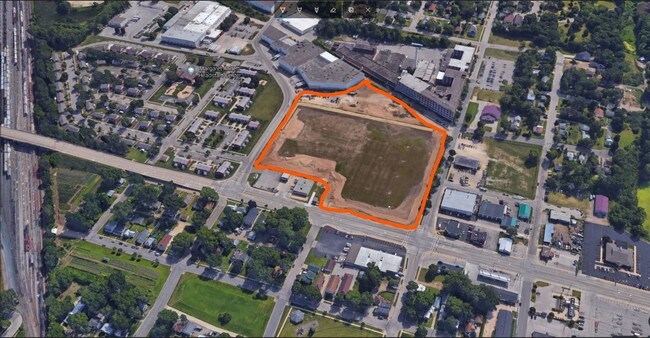
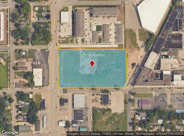
Property Record
1319 St Andrew St, La Crosse, WI 54603
NEARBY LISTINGS FOR SALE OR LEASE
Property Detail
1319 St Andrew St
La Crosse-Onalaska, WI-MN
Section 29 T16n R7w
017-010289-040
PRT SW-NE COM W1/4 COR SEC 29 N89D13M55SE 2646.22FT N0D50M40SW 30.66FT N89D37M8SE 36.1FT ALG N R/W ST ANDREW ST TO POB N0D48M22SW 100FT ALG ELY R/W LN GEORGE ST N2D4M38SW 307.38FT ALG ELY R/W LN GEORGE ST N88D54M6SE 110.8FT N0D50M18SW 52.07FT N89D0M1
Commercialnec
La Crosse
AE
Wisconsin
27055C0125E
5.27 AC
2024
La Crosse/Onalaska
2024
Other Market Areas
000100
DEMOGRAPHICS near 1319 St Andrew St
1 Mile
3 Mile
5 Mile
2024 Total Population
7,028
47,106
85,069
2029 Population
7,186
47,698
86,202
Pop Growth 2024-2029
+ 2.25%
+ 1.26%
+ 1.33%
Average Age
37
37
39
2024 Total Households
3,277
19,855
36,502
HH Growth 2024-2029
+ 1.89%
+ 1.28%
+ 1.39%
Median Household Inc
$44,068
$45,621
$54,432
Avg Household Size
2.10
2.10
2.10
2024 Avg HH Vehicles
1.00
2.00
2.00
Median Home Value
$127,398
$175,219
$197,416
Median Year Built
1956
1963
1973
Nearby Places
Map Layers
Map Styles
 Street
 Aerial
- Restaurants
- Banks
- Shops
- Fitness
- Groceries
PUBLIC TRANSPORTATION
COMMUTER RAIL
La Crosse (Empire Builder - Amtrak)
DRIVE
WALK
Distance
La Crosse (Empire Builder - Amtrak)
1 min
8 min
0.4 mi
AIRPORT
La Crosse Regional
DRIVE
WALK
Distance
La Crosse Regional
13 min
4.8 mi
Freight Ports
Port Milwaukee
DRIVE
WALK
Distance
Port Milwaukee
235 min
210.1 mi
SALE & LEASE HISTORY
LISTING DATE
SALE/LEASE

Jul 24, 2017
For Sale
Jul 12, 2017
For Sale
Apr 21, 2017
For Sale
Nearby Properties
Address
Land Use
TOTAL SIZE
Lot Size
Zoning
Address
Land Use
TOTAL SIZE
Lot Size
Zoning
4.65 AC
Address
Land Use
TOTAL SIZE
Lot Size
Zoning
42.20 AC
MZA
Address
Land Use
TOTAL SIZE
Lot Size
Zoning
38,407 SF
3.12 AC
MZA
Address
Land Use
TOTAL SIZE
Lot Size
Zoning
12.60 AC
MZA
Address
Land Use
TOTAL SIZE
Lot Size
Zoning
14.59 AC
MZA
Address
Land Use
TOTAL SIZE
Lot Size
Zoning
0.75 AC
MZA
Address
Land Use
TOTAL SIZE
Lot Size
Zoning
54.26 AC
MZA
Address
Land Use
TOTAL SIZE
Lot Size
Zoning
131,552 SF
0.89 AC
Address
Land Use
TOTAL SIZE
Lot Size
Zoning
11.40 AC
MZA
Address
Land Use
TOTAL SIZE
Lot Size
Zoning
29.80 AC
MZA
Address
Land Use
TOTAL SIZE
Lot Size
Zoning
12,500 SF
5.12 AC
MZA
Address
Land Use
TOTAL SIZE
Lot Size
Zoning
3.91 AC
Address
Land Use
TOTAL SIZE
Lot Size
Zoning
73,056 SF
0.62 AC
Address
Land Use
TOTAL SIZE
Lot Size
Zoning
4.81 AC
Address
Land Use
TOTAL SIZE
Lot Size
Zoning
64,480 SF
0.69 AC
MZA
Address
Land Use
TOTAL SIZE
Lot Size
Zoning
5.29 AC
MZA
Address
Land Use
TOTAL SIZE
Lot Size
Zoning
0.12 AC
Address
Land Use
TOTAL SIZE
Lot Size
Zoning
54,884 SF
1.09 AC
MZA
Address
Land Use
TOTAL SIZE
Lot Size
Zoning
2.10 AC
MZA
Address
Land Use
TOTAL SIZE
Lot Size
Zoning
2.12 AC
MZA
Address
Land Use
TOTAL SIZE
Lot Size
Zoning
5.79 AC
MZA
Address
Land Use
TOTAL SIZE
Lot Size
Zoning
11.04 AC
MZA
Address
Land Use
TOTAL SIZE
Lot Size
Zoning
162,355 SF
13.90 AC
MZA
Address
Land Use
TOTAL SIZE
Lot Size
Zoning
8.40 AC
MZA
Address
Land Use
TOTAL SIZE
Lot Size
Zoning
2.43 AC
Address
Land Use
TOTAL SIZE
Lot Size
Zoning
0.56 AC
MZA
Address
Land Use
TOTAL SIZE
Lot Size
Zoning
8.98 AC
MZA
Address
Land Use
TOTAL SIZE
Lot Size
Zoning
27,000 SF
0.22 AC
MZA
Address
Land Use
TOTAL SIZE
Lot Size
Zoning
7.59 AC
MZA
Address
Land Use
TOTAL SIZE
Lot Size
Zoning
81,664 SF
1.06 AC
MZA
The World's #1 Commercial Real Estate Marketplace
Connect with us
© 2026 CoStar Group
The information above has been obtained from sources believed reliable. While we do not doubt its accuracy we have not verified it and make no guarantee, warranty or representation about it. It is your responsibility to independently confirm its accuracy and completeness. Any projections, opinions, assumptions, or estimates used are for example only and do not represent the current or future performance of the property. The value of this transaction to you depends on tax and other factors which should be evaluated by your tax, financial, and legal advisors. You and your advisors should conduct a careful, independent investigation of the property to determine to your satisfaction the suitability of the property for your needs.