Property Record
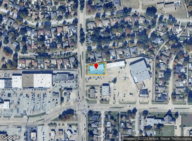
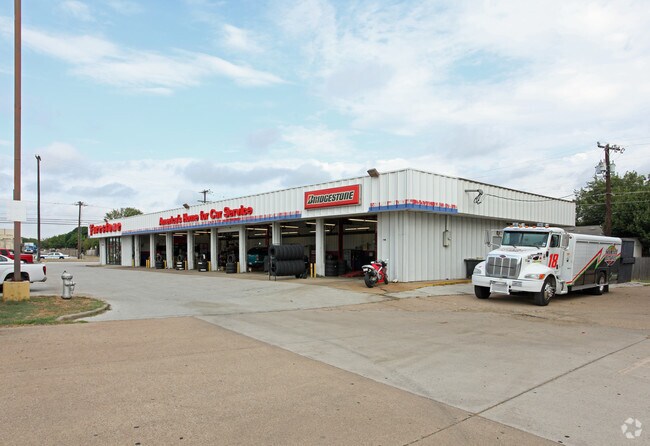
1325 W Buckingham Rd, Garland, TX 75040

NEARBY LISTINGS FOR SALE OR LEASE
Property Detail
1325 W Buckingham Rd
Dallas-Fort Worth-Arlington, TX
Buckingham North Estates
26057500270010700
BUCKINGHAM NORTH ESTATES BLK 27 LT 1.7 ACS 0.5025 VOL2001237/1368 DD11302001 CO-DC 0575002700107 32605750027
Autorepair
Dallas
X
Texas
48113C0220L
1
2024
0.50 AC
2025
Garland
019026
Dallas/Ft Worth
6,900 SF
DEMOGRAPHICS near 1325 W Buckingham Rd
1 Mile
3 Mile
5 Mile
2024 Total Population
17,699
132,705
323,739
2029 Population
17,342
130,819
325,536
Pop Growth 2024-2029
(2.02%)
(1.42%)
+ 0.56%
Average Age
40
38
38
2024 Total Households
5,771
43,769
113,200
HH Growth 2024-2029
(2.25%)
(1.61%)
+ 0.49%
Median Household Inc
$63,194
$64,871
$67,456
Avg Household Size
3.00
2.90
2.80
2024 Avg HH Vehicles
2.00
2.00
2.00
Median Home Value
$213,624
$223,324
$257,536
Median Year Built
1974
1977
1981
Nearby Places
Map Layers
Map Styles
 Street
 Aerial
- Restaurants
- Banks
- Shops
- Fitness
- Groceries
PUBLIC TRANSPORTATION
AIRPORT
Dallas Love Field
DRIVE
WALK
Distance
Dallas Love Field
33 min
20.0 mi
Dallas-Fort Worth International
DRIVE
WALK
Distance
Dallas-Fort Worth International
41 min
28.9 mi
Nearby Properties
Address
Land Use
TOTAL SIZE
Lot Size
Zoning
Address
Land Use
TOTAL SIZE
Lot Size
Zoning
768,061 SF
42.03 AC
Z02
Address
Land Use
TOTAL SIZE
Lot Size
Zoning
650,164 SF
66.57 AC
Z02
Address
Land Use
TOTAL SIZE
Lot Size
Zoning
353,347 SF
17 AC
Z02
Address
Land Use
TOTAL SIZE
Lot Size
Zoning
426,467 SF
24.12 AC
Z142
Address
Land Use
TOTAL SIZE
Lot Size
Zoning
433,745 SF
15.18 AC
Z02
Address
Land Use
TOTAL SIZE
Lot Size
Zoning
310,382 SF
11.78 AC
Z148
Address
Land Use
TOTAL SIZE
Lot Size
Zoning
181,200 SF
15.11 AC
Address
Land Use
TOTAL SIZE
Lot Size
Zoning
181,854 SF
14.51 AC
Z239
Address
Land Use
TOTAL SIZE
Lot Size
Zoning
388,059 SF
21.80 AC
Z239
Address
Land Use
TOTAL SIZE
Lot Size
Zoning
342,658 SF
4.94 AC
Z239
Address
Land Use
TOTAL SIZE
Lot Size
Zoning
244,025 SF
17.80 AC
Z02
Address
Land Use
TOTAL SIZE
Lot Size
Zoning
331,684 SF
9.80 AC
Z148
Address
Land Use
TOTAL SIZE
Lot Size
Zoning
403,206 SF
4 AC
Z239
Address
Land Use
TOTAL SIZE
Lot Size
Zoning
276,236 SF
8.96 AC
Z239
Address
Land Use
TOTAL SIZE
Lot Size
Zoning
107,686 SF
30.09 AC
Z386
Address
Land Use
TOTAL SIZE
Lot Size
Zoning
232,771 SF
15.69 AC
Z160
Address
Land Use
TOTAL SIZE
Lot Size
Zoning
245,596 SF
14.24 AC
Z160
Address
Land Use
TOTAL SIZE
Lot Size
Zoning
117,500 SF
16.71 AC
Z239
Address
Land Use
TOTAL SIZE
Lot Size
Zoning
65,595 SF
19.22 AC
Z239
Address
Land Use
TOTAL SIZE
Lot Size
Zoning
286,500 SF
14.98 AC
Z160
Address
Land Use
TOTAL SIZE
Lot Size
Zoning
187,440 SF
1.68 AC
Z25
Address
Land Use
TOTAL SIZE
Lot Size
Zoning
77,102 SF
27.47 AC
Z144
Address
Land Use
TOTAL SIZE
Lot Size
Zoning
226,524 SF
10.31 AC
Z160
Address
Land Use
TOTAL SIZE
Lot Size
Zoning
227,624 SF
10.31 AC
Z160
Address
Land Use
TOTAL SIZE
Lot Size
Zoning
392,736 SF
19.58 AC
Z144
Address
Land Use
TOTAL SIZE
Lot Size
Zoning
198,950 SF
10 AC
Z160
Address
Land Use
TOTAL SIZE
Lot Size
Zoning
225,643 SF
10.42 AC
Z239
Address
Land Use
TOTAL SIZE
Lot Size
Zoning
198,488 SF
10.17 AC
Z239
Address
Land Use
TOTAL SIZE
Lot Size
Zoning
114,738 SF
13.77 AC
Z207
Address
Land Use
TOTAL SIZE
Lot Size
Zoning
162,456 SF
10.72 AC
Z160
The World's #1 Commercial Real Estate Marketplace
Connect with us
© 2025 CoStar Group
The information above has been obtained from sources believed reliable. While we do not doubt its accuracy we have not verified it and make no guarantee, warranty or representation about it. It is your responsibility to independently confirm its accuracy and completeness. Any projections, opinions, assumptions, or estimates used are for example only and do not represent the current or future performance of the property. The value of this transaction to you depends on tax and other factors which should be evaluated by your tax, financial, and legal advisors. You and your advisors should conduct a careful, independent investigation of the property to determine to your satisfaction the suitability of the property for your needs.