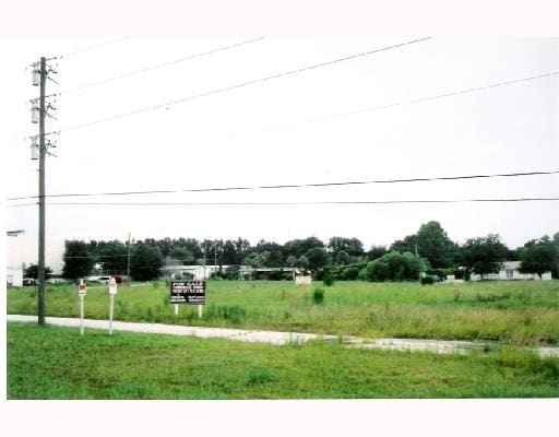
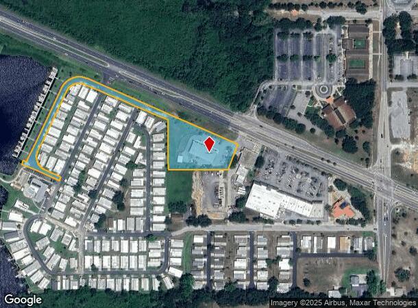
Property Record
1325 W Highway 50, Clermont, FL 34711

NEARBY LISTINGS FOR SALE OR LEASE
Property Detail
1325 W Highway 50
23-22-25-0004-000-01203
THAT PART OF GOV LOT 7 DESCRIBED AS: FROM INT OF CENTERLINES OF SR 50 & SR 561 RUN S 181.02 FT TO A PT 30 FT N OF CENTER- LINES OF BROOME ST & SR 561 N 89-18-22 W PARALLEL WITH 30 FT NLY OF CENTERLINE OF SAID BROOME STREET A DIST OF 992.87 FT S 0-41-
Stripcommercialcenter
Lake
AE
Florida
12069C0570E
7
2024
2.36 AC
2026
Lake County
031202
Orlando
7,560 SF
Orlando-Kissimmee-Sanford, FL
DEMOGRAPHICS near 1325 W Highway 50
1 Mile
3 Mile
5 Mile
2024 Total Population
3,436
31,786
91,751
2029 Population
4,020
36,956
107,214
Pop Growth 2024-2029
+ 17.00%
+ 16.27%
+ 16.85%
Average Age
42
40
41
2024 Total Households
1,375
11,853
33,394
HH Growth 2024-2029
+ 16.80%
+ 16.02%
+ 16.61%
Median Household Inc
$74,844
$75,888
$81,516
Avg Household Size
2.50
2.60
2.70
2024 Avg HH Vehicles
2.00
2.00
2.00
Median Home Value
$319,140
$290,388
$316,544
Median Year Built
1989
1999
2003
Nearby Places
Map Layers
Map Styles
 Street
 Aerial
- Restaurants
- Banks
- Shops
- Fitness
- Groceries
PUBLIC TRANSPORTATION
AIRPORT
Orlando International
DRIVE
WALK
Distance
Orlando International
48 min
34.8 mi
Freight Ports
Port of Tampa Bay
DRIVE
WALK
Distance
Port of Tampa Bay
96 min
73.8 mi
Nearby Properties
Address
Land Use
TOTAL SIZE
Lot Size
Zoning
Address
Land Use
TOTAL SIZE
Lot Size
Zoning
403,970 SF
30.99 AC
PUD
Address
Land Use
TOTAL SIZE
Lot Size
Zoning
179,290 SF
23.79 AC
Address
Land Use
TOTAL SIZE
Lot Size
Zoning
204,472 SF
43.52 AC
Address
Land Use
TOTAL SIZE
Lot Size
Zoning
Address
Land Use
TOTAL SIZE
Lot Size
Zoning
142,824 SF
9.90 AC
C2
Address
Land Use
TOTAL SIZE
Lot Size
Zoning
203,762 SF
18.28 AC
R1
Address
Land Use
TOTAL SIZE
Lot Size
Zoning
95,182 SF
12.34 AC
PUD
Address
Land Use
TOTAL SIZE
Lot Size
Zoning
158,351 SF
19.10 AC
C2
Address
Land Use
TOTAL SIZE
Lot Size
Zoning
80,774 SF
6.61 AC
Address
Land Use
TOTAL SIZE
Lot Size
Zoning
74,375 SF
6.69 AC
Address
Land Use
TOTAL SIZE
Lot Size
Zoning
99,348 SF
34.10 AC
R1A
Address
Land Use
TOTAL SIZE
Lot Size
Zoning
66,526 SF
8.98 AC
C1
Address
Land Use
TOTAL SIZE
Lot Size
Zoning
2,000 SF
55.61 AC
CFD
Address
Land Use
TOTAL SIZE
Lot Size
Zoning
123,387 SF
47.51 AC
R3
Address
Land Use
TOTAL SIZE
Lot Size
Zoning
30,926 SF
0.38 AC
Address
Land Use
TOTAL SIZE
Lot Size
Zoning
81,188 SF
7.70 AC
C2
Address
Land Use
TOTAL SIZE
Lot Size
Zoning
59,648 SF
8.86 AC
R6
Address
Land Use
TOTAL SIZE
Lot Size
Zoning
73,040 SF
4.89 AC
I1
Address
Land Use
TOTAL SIZE
Lot Size
Zoning
104,532 SF
8.35 AC
Address
Land Use
TOTAL SIZE
Lot Size
Zoning
47,210 SF
3.75 AC
M1
Address
Land Use
TOTAL SIZE
Lot Size
Zoning
40,798 SF
7.51 AC
P
Address
Land Use
TOTAL SIZE
Lot Size
Zoning
52,788 SF
3.21 AC
R2
Address
Land Use
TOTAL SIZE
Lot Size
Zoning
95,176 SF
11.02 AC
PUD
Address
Land Use
TOTAL SIZE
Lot Size
Zoning
102,584 SF
9.21 AC
R3
Address
Land Use
TOTAL SIZE
Lot Size
Zoning
24,910 SF
3.44 AC
CBD
Address
Land Use
TOTAL SIZE
Lot Size
Zoning
29,892 SF
2.46 AC
R3
Address
Land Use
TOTAL SIZE
Lot Size
Zoning
44,277 SF
3.44 AC
C2
Address
Land Use
TOTAL SIZE
Lot Size
Zoning
48,344 SF
6.03 AC
Address
Land Use
TOTAL SIZE
Lot Size
Zoning
34,840 SF
2.97 AC
C2
Address
Land Use
TOTAL SIZE
Lot Size
Zoning
51,605 SF
3.26 AC
C2
The World's #1 Commercial Real Estate Marketplace
Connect with us
© 2026 CoStar Group
The information above has been obtained from sources believed reliable. While we do not doubt its accuracy we have not verified it and make no guarantee, warranty or representation about it. It is your responsibility to independently confirm its accuracy and completeness. Any projections, opinions, assumptions, or estimates used are for example only and do not represent the current or future performance of the property. The value of this transaction to you depends on tax and other factors which should be evaluated by your tax, financial, and legal advisors. You and your advisors should conduct a careful, independent investigation of the property to determine to your satisfaction the suitability of the property for your needs.