Property Record
13268 Ga Highway 315, Cataula, GA 31804
NEARBY LISTINGS FOR SALE OR LEASE
-
-
View all Cataula listings for lease on LoopNet.com
Property Detail
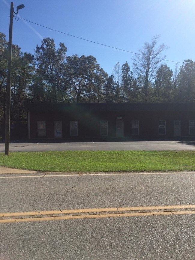
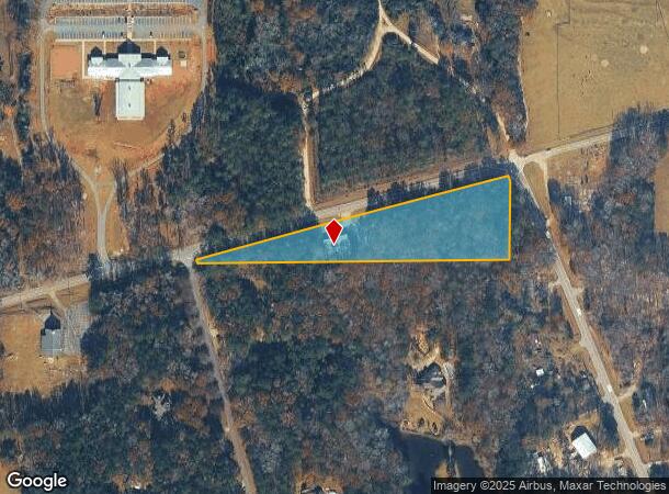
13268 Ga Highway 315
Columbus, GA-AL
Ac 10000
062-002
DIST 18 LL 203 LANDLOT: 203 LANDDIST: 18
Stripcommercialcenter
Harris
X
Georgia
13145C0215C
203
2025
3.69 AC
2025
Harris County
120401
Columbus GA
3,000 SF
DEMOGRAPHICS near 13268 Ga Highway 315
1 Mile
3 Mile
5 Mile
2024 Total Population
572
2,875
9,938
2029 Population
647
3,247
11,218
Pop Growth 2024-2029
+ 13.11%
+ 12.94%
+ 12.88%
Average Age
42
42
42
2024 Total Households
208
1,037
3,562
HH Growth 2024-2029
+ 12.98%
+ 12.73%
+ 12.66%
Median Household Inc
$105,208
$99,700
$100,693
Avg Household Size
2.70
2.70
2.80
2024 Avg HH Vehicles
2.00
3.00
3.00
Median Home Value
$303,488
$289,067
$291,221
Median Year Built
1995
1995
1996
Nearby Places
Map Layers
Map Styles
 Street
 Aerial
- Restaurants
- Banks
- Shops
- Fitness
- Groceries
PUBLIC TRANSPORTATION
AIRPORT
Columbus
DRIVE
WALK
Distance
Columbus
23 min
13.5 mi
SALE & LEASE HISTORY
LISTING DATE
SALE/LEASE

Sep 25, 2016
For Lease
Nearby Properties
Address
Land Use
TOTAL SIZE
Lot Size
Zoning
Address
Land Use
TOTAL SIZE
Lot Size
Zoning
58,144 SF
82.42 AC
004
Address
Land Use
TOTAL SIZE
Lot Size
Zoning
3,000 SF
4.94 AC
002
Address
Land Use
TOTAL SIZE
Lot Size
Zoning
13,539 SF
14 AC
004
Address
Land Use
TOTAL SIZE
Lot Size
Zoning
231.86 AC
004
Address
Land Use
TOTAL SIZE
Lot Size
Zoning
2,145 SF
143.27 AC
004
Address
Land Use
TOTAL SIZE
Lot Size
Zoning
238.96 AC
004
Address
Land Use
TOTAL SIZE
Lot Size
Zoning
219.99 AC
004
Address
Land Use
TOTAL SIZE
Lot Size
Zoning
9,020 SF
1.08 AC
002
Address
Land Use
TOTAL SIZE
Lot Size
Zoning
9,000 SF
11.50 AC
002
Address
Land Use
TOTAL SIZE
Lot Size
Zoning
1,178 SF
137.67 AC
004
Address
Land Use
TOTAL SIZE
Lot Size
Zoning
8,000 SF
1.40 AC
002
Address
Land Use
TOTAL SIZE
Lot Size
Zoning
109 AC
004
Address
Land Use
TOTAL SIZE
Lot Size
Zoning
104.79 AC
001
Address
Land Use
TOTAL SIZE
Lot Size
Zoning
95.07 AC
004
Address
Land Use
TOTAL SIZE
Lot Size
Zoning
3,479 SF
4 AC
002
Address
Land Use
TOTAL SIZE
Lot Size
Zoning
62.55 AC
004
Address
Land Use
TOTAL SIZE
Lot Size
Zoning
6,600 SF
1.31 AC
002
Address
Land Use
TOTAL SIZE
Lot Size
Zoning
73.35 AC
004
Address
Land Use
TOTAL SIZE
Lot Size
Zoning
2,680 SF
2.07 AC
002
Address
Land Use
TOTAL SIZE
Lot Size
Zoning
2,480 SF
2 AC
002
Address
Land Use
TOTAL SIZE
Lot Size
Zoning
2,304 SF
43.91 AC
004
Address
Land Use
TOTAL SIZE
Lot Size
Zoning
47.62 AC
004
Address
Land Use
TOTAL SIZE
Lot Size
Zoning
4,320 SF
2.11 AC
004
Address
Land Use
TOTAL SIZE
Lot Size
Zoning
37.83 AC
004
Address
Land Use
TOTAL SIZE
Lot Size
Zoning
4,800 SF
0.81 AC
001
Address
Land Use
TOTAL SIZE
Lot Size
Zoning
3,966 SF
2.80 AC
001
Address
Land Use
TOTAL SIZE
Lot Size
Zoning
43.28 AC
004
Address
Land Use
TOTAL SIZE
Lot Size
Zoning
288 SF
43.91 AC
004
The World's #1 Commercial Real Estate Marketplace
Connect with us
© 2026 CoStar Group
The information above has been obtained from sources believed reliable. While we do not doubt its accuracy we have not verified it and make no guarantee, warranty or representation about it. It is your responsibility to independently confirm its accuracy and completeness. Any projections, opinions, assumptions, or estimates used are for example only and do not represent the current or future performance of the property. The value of this transaction to you depends on tax and other factors which should be evaluated by your tax, financial, and legal advisors. You and your advisors should conduct a careful, independent investigation of the property to determine to your satisfaction the suitability of the property for your needs.