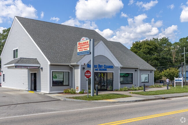
Property Record
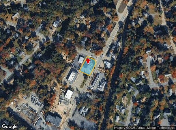
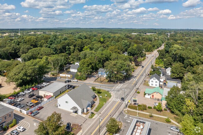
1327 Main St, Walpole, MA 02081
NEARBY LISTINGS FOR SALE OR LEASE
Property Detail
1327 Main St
Storebuilding
Norfolk
X
Massachusetts
25021C0169F
0.38 AC
2025
I-95 Corridor South
2025
Boston
411302
Boston-Cambridge-Newton, MA-NH
5,335 SF
WALP-000041-000152
DEMOGRAPHICS near 1327 Main St
1 Mile
3 Mile
5 Mile
2024 Total Population
4,871
30,324
88,720
2029 Population
4,990
30,370
88,329
Pop Growth 2024-2029
+ 2.44%
+ 0.15%
(0.44%)
Average Age
43
41
41
2024 Total Households
2,004
10,756
32,383
HH Growth 2024-2029
+ 2.84%
+ 0.29%
(0.48%)
Median Household Inc
$113,285
$144,916
$137,454
Avg Household Size
2.40
2.70
2.70
2024 Avg HH Vehicles
2.00
2.00
2.00
Median Home Value
$517,114
$674,578
$667,083
Median Year Built
1978
1977
1970
Nearby Places
Map Layers
Map Styles
 Street
 Aerial
- Restaurants
- Banks
- Shops
- Fitness
- Groceries
PUBLIC TRANSPORTATION
COMMUTER RAIL
Walpole (Foxboro Line (Special Events Only) - Massachusetts Bay Transportation Authority Commuter Rail (Purple Line), Franklin Line - Massachusetts Bay Transportation Authority Commuter Rail (Purple Line))
DRIVE
WALK
Distance
Walpole (Foxboro Line (Special Events Only) - Massachusetts Bay Transportation Authority Commuter Rail (Purple Line), Franklin Line - Massachusetts Bay Transportation Authority Commuter Rail (Purple Line))
2 min
20 min
1.0 mi
Foxboro (Special Events Only) (Foxboro Line (Special Events Only) - Massachusetts Bay Transportation Authority Commuter Rail (Purple Line))
DRIVE
WALK
Distance
Foxboro (Special Events Only) (Foxboro Line (Special Events Only) - Massachusetts Bay Transportation Authority Commuter Rail (Purple Line))
9 min
3.9 mi
AIRPORT
General Edward Lawrence Logan International
DRIVE
WALK
Distance
General Edward Lawrence Logan International
44 min
29.7 mi
Rhode Island Tf Green International
DRIVE
WALK
Distance
Rhode Island Tf Green International
55 min
38.0 mi
Freight Ports
Port of Boston
DRIVE
WALK
Distance
Port of Boston
42 min
24.3 mi
SALE & LEASE HISTORY
LISTING DATE
SALE/LEASE

Sep 03, 2024
For Lease
Jan 15, 2020
For Lease
Jan 10, 2025
For Lease
Nearby Properties
Address
Land Use
TOTAL SIZE
Lot Size
Zoning
Address
Land Use
TOTAL SIZE
Lot Size
Zoning
Address
Land Use
TOTAL SIZE
Lot Size
Zoning
198,498 SF
14 AC
Address
Land Use
TOTAL SIZE
Lot Size
Zoning
97.60 AC
Address
Land Use
TOTAL SIZE
Lot Size
Zoning
245,693 SF
2.57 AC
Address
Land Use
TOTAL SIZE
Lot Size
Zoning
2,385 SF
21.39 AC
Address
Land Use
TOTAL SIZE
Lot Size
Zoning
1,080 SF
10.07 AC
Address
Land Use
TOTAL SIZE
Lot Size
Zoning
14.33 AC
Address
Land Use
TOTAL SIZE
Lot Size
Zoning
211,362 SF
2.39 AC
Address
Land Use
TOTAL SIZE
Lot Size
Zoning
89,960 SF
52.40 AC
Address
Land Use
TOTAL SIZE
Lot Size
Zoning
79,901 SF
11.46 AC
Address
Land Use
TOTAL SIZE
Lot Size
Zoning
11.98 AC
Address
Land Use
TOTAL SIZE
Lot Size
Zoning
117.30 AC
Address
Land Use
TOTAL SIZE
Lot Size
Zoning
52,214 SF
20 AC
Address
Land Use
TOTAL SIZE
Lot Size
Zoning
93,218 SF
9.68 AC
LI
Address
Land Use
TOTAL SIZE
Lot Size
Zoning
59,390 SF
5.69 AC
Address
Land Use
TOTAL SIZE
Lot Size
Zoning
64,887 SF
21.10 AC
Address
Land Use
TOTAL SIZE
Lot Size
Zoning
54,948 SF
11.43 AC
Address
Land Use
TOTAL SIZE
Lot Size
Zoning
814.08 AC
Address
Land Use
TOTAL SIZE
Lot Size
Zoning
56,414 SF
7.63 AC
Address
Land Use
TOTAL SIZE
Lot Size
Zoning
102,024 SF
9.97 AC
LI
Address
Land Use
TOTAL SIZE
Lot Size
Zoning
147,984 SF
20.57 AC
Address
Land Use
TOTAL SIZE
Lot Size
Zoning
101,171 SF
11.12 AC
LI
Address
Land Use
TOTAL SIZE
Lot Size
Zoning
124,519 SF
14.22 AC
LI
Address
Land Use
TOTAL SIZE
Lot Size
Zoning
73,607 SF
11.70 AC
Address
Land Use
TOTAL SIZE
Lot Size
Zoning
61,880 SF
6.06 AC
Address
Land Use
TOTAL SIZE
Lot Size
Zoning
46,536 SF
1.64 AC
Address
Land Use
TOTAL SIZE
Lot Size
Zoning
19,654 SF
0.20 AC
Address
Land Use
TOTAL SIZE
Lot Size
Zoning
3.01 AC
Address
Land Use
TOTAL SIZE
Lot Size
Zoning
97,621 SF
28.31 AC
LI
Address
Land Use
TOTAL SIZE
Lot Size
Zoning
1,536 SF
63.73 AC
The World's #1 Commercial Real Estate Marketplace
Connect with us
© 2025 CoStar Group
The information above has been obtained from sources believed reliable. While we do not doubt its accuracy we have not verified it and make no guarantee, warranty or representation about it. It is your responsibility to independently confirm its accuracy and completeness. Any projections, opinions, assumptions, or estimates used are for example only and do not represent the current or future performance of the property. The value of this transaction to you depends on tax and other factors which should be evaluated by your tax, financial, and legal advisors. You and your advisors should conduct a careful, independent investigation of the property to determine to your satisfaction the suitability of the property for your needs.