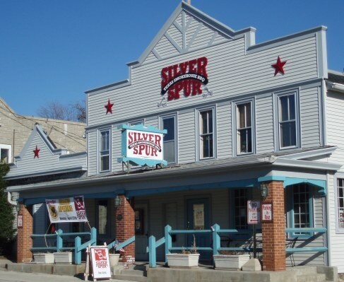
Property Record
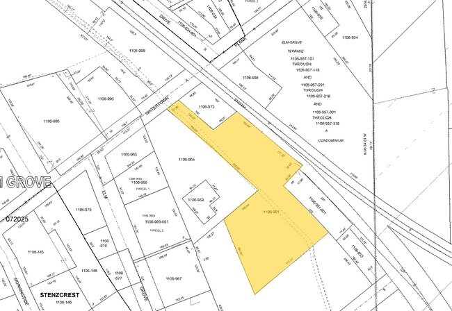
13275 Watertown Plank Rd, Elm Grove, WI 53122

NEARBY LISTINGS FOR SALE OR LEASE
Property Detail
13275 Watertown Plank Rd
Milwaukee-Waukesha-West Allis, WI
Watertown Plank
EGV-1106-954
PT NW1/4 SEC 25 T7N R20E; COM NE COR NW1/4 SEC 25; S ALG E LI OF SAID 1/4 SEC 513.0 FT TO POINT BEING CALLED THE CTRLI OF WATERTOWN PLANK RD BY PREVIOUS DESCRIPTIONS; S5330W ALG CTRLI 148.50 FT THE BGN; S2757E 255.28 FT TO POINT IN E LI OF SAID 1/4 S
Commercialnec
Waukesha
X
Wisconsin
55133C0237H
7
2024
0.97 AC
2024
Brookfield/New Berlin
201001
Milwaukee/Madison
4,802 SF
DEMOGRAPHICS near 13275 Watertown Plank Rd
1 Mile
3 Mile
5 Mile
2024 Total Population
7,675
61,497
236,720
2029 Population
7,890
62,663
237,077
Pop Growth 2024-2029
+ 2.80%
+ 1.90%
+ 0.15%
Average Age
44
42
41
2024 Total Households
3,046
26,090
103,450
HH Growth 2024-2029
+ 2.86%
+ 1.72%
+ 0.03%
Median Household Inc
$106,761
$90,542
$77,692
Avg Household Size
2.40
2.30
2.20
2024 Avg HH Vehicles
2.00
2.00
2.00
Median Home Value
$372,625
$301,478
$263,650
Median Year Built
1961
1964
1959
Nearby Places
Map Layers
Map Styles
 Street
 Aerial
- Restaurants
- Banks
- Shops
- Fitness
- Groceries
PUBLIC TRANSPORTATION
COMMUTER RAIL
DRIVE
WALK
Distance
17 min
9.4 mi
AIRPORT
General Mitchell International
DRIVE
WALK
Distance
General Mitchell International
28 min
15.7 mi
Freight Ports
Port Milwaukee
DRIVE
WALK
Distance
Port Milwaukee
22 min
11.9 mi
SALE & LEASE HISTORY
LISTING DATE
SALE/LEASE

Jan 17, 2018
For Sale
Nearby Properties
Address
Land Use
TOTAL SIZE
Lot Size
Zoning
Address
Land Use
TOTAL SIZE
Lot Size
Zoning
70.73 AC
Address
Land Use
TOTAL SIZE
Lot Size
Zoning
8.63 AC
C2
Address
Land Use
TOTAL SIZE
Lot Size
Zoning
24.46 AC
Address
Land Use
TOTAL SIZE
Lot Size
Zoning
Address
Land Use
TOTAL SIZE
Lot Size
Zoning
19.25 AC
Address
Land Use
TOTAL SIZE
Lot Size
Zoning
18.95 AC
Address
Land Use
TOTAL SIZE
Lot Size
Zoning
23.16 AC
Address
Land Use
TOTAL SIZE
Lot Size
Zoning
4.54 AC
Address
Land Use
TOTAL SIZE
Lot Size
Zoning
78,185 SF
73.67 AC
M1
Address
Land Use
TOTAL SIZE
Lot Size
Zoning
12.50 AC
Address
Land Use
TOTAL SIZE
Lot Size
Zoning
20.02 AC
Address
Land Use
TOTAL SIZE
Lot Size
Zoning
4.99 AC
Address
Land Use
TOTAL SIZE
Lot Size
Zoning
Address
Land Use
TOTAL SIZE
Lot Size
Zoning
1.91 AC
Address
Land Use
TOTAL SIZE
Lot Size
Zoning
13.48 AC
Address
Land Use
TOTAL SIZE
Lot Size
Zoning
17.45 AC
Address
Land Use
TOTAL SIZE
Lot Size
Zoning
10.48 AC
Address
Land Use
TOTAL SIZE
Lot Size
Zoning
28,800 SF
3.30 AC
C2
Address
Land Use
TOTAL SIZE
Lot Size
Zoning
Address
Land Use
TOTAL SIZE
Lot Size
Zoning
10.22 AC
SP-RP
Address
Land Use
TOTAL SIZE
Lot Size
Zoning
7.20 AC
Address
Land Use
TOTAL SIZE
Lot Size
Zoning
Address
Land Use
TOTAL SIZE
Lot Size
Zoning
2.45 AC
C2
Address
Land Use
TOTAL SIZE
Lot Size
Zoning
Address
Land Use
TOTAL SIZE
Lot Size
Zoning
3.55 AC
Address
Land Use
TOTAL SIZE
Lot Size
Zoning
1.84 AC
Address
Land Use
TOTAL SIZE
Lot Size
Zoning
Address
Land Use
TOTAL SIZE
Lot Size
Zoning
4.79 AC
Address
Land Use
TOTAL SIZE
Lot Size
Zoning
4.53 AC
Address
Land Use
TOTAL SIZE
Lot Size
Zoning
The World's #1 Commercial Real Estate Marketplace
Connect with us
© 2025 CoStar Group
The information above has been obtained from sources believed reliable. While we do not doubt its accuracy we have not verified it and make no guarantee, warranty or representation about it. It is your responsibility to independently confirm its accuracy and completeness. Any projections, opinions, assumptions, or estimates used are for example only and do not represent the current or future performance of the property. The value of this transaction to you depends on tax and other factors which should be evaluated by your tax, financial, and legal advisors. You and your advisors should conduct a careful, independent investigation of the property to determine to your satisfaction the suitability of the property for your needs.