Property Record
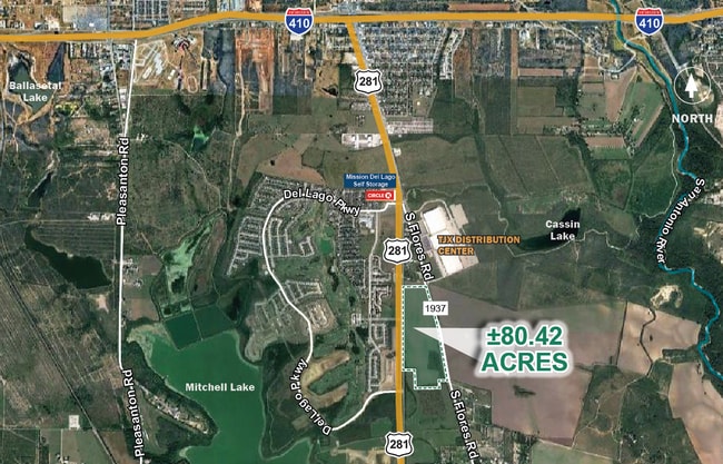
13279 Fm 1937, San Antonio, TX 78221

NEARBY LISTINGS FOR SALE OR LEASE
-
-
-
-
-
Loop 410 @ S Zarzamora St & Pleasanton Rd
San Antonio, TX 78221
Rent Upon Request
29.45 - 590.87 AC Lot
Land
-
-
-
View all San Antonio listings for sale on LoopNet.com
Property Detail
13279 Fm 1937
San Antonio-New Braunfels, TX
Conv A/S Code
15667-000-0110
NCB 15667 P-11 (78.248), P-12 (1.52 AC) & CB 4006-1 P-11 (0.652) ABS 3 (S SIDE GOLF CRSE E ANNEXTN) 2022-REMAINS PER BCAD MERGE TO MATCH ACREAGE PER DEED 20210279111 (CONVEYS 80.42 ACRES) EXE 10-5-2021. SEE ATTACHED SURVEY MAP (CR 55355). JF/GIS/3-31
Privatepreserveopenspacevacantlandforestlandconservation
Bexar
X
Texas
48029C0590G
11
2024
80.42 AC
2025
South
151700
San Antonio
DEMOGRAPHICS near 13279 Fm 1937
1 Mile
3 Mile
5 Mile
2024 Total Population
4,557
20,001
82,768
2029 Population
5,053
21,767
88,978
Pop Growth 2024-2029
+ 10.88%
+ 8.83%
+ 7.50%
Average Age
32
34
36
2024 Total Households
1,470
6,208
27,088
HH Growth 2024-2029
+ 11.02%
+ 9.00%
+ 7.60%
Median Household Inc
$76,623
$67,761
$53,750
Avg Household Size
3.10
3.10
3.00
2024 Avg HH Vehicles
2.00
2.00
2.00
Median Home Value
$232,318
$177,430
$155,404
Median Year Built
2011
2006
1987
Nearby Places
Map Layers
Map Styles
 Street
 Aerial
- Restaurants
- Banks
- Shops
- Fitness
- Groceries
PUBLIC TRANSPORTATION
COMMUTER RAIL
San Antonio Amtrak Station (Sunset Limited - Amtrak, Texas Eagle - Amtrak)
DRIVE
WALK
Distance
San Antonio Amtrak Station (Sunset Limited - Amtrak, Texas Eagle - Amtrak)
18 min
10.0 mi
AIRPORT
San Antonio International
DRIVE
WALK
Distance
San Antonio International
27 min
17.8 mi
Freight Ports
Port of Corpus Christi
DRIVE
WALK
Distance
Port of Corpus Christi
145 min
137.1 mi
SALE & LEASE HISTORY
LISTING DATE
SALE/LEASE

Sep 24, 2016
For Sale
Sep 24, 2016
For Sale
Feb 22, 2023
For Sale
Nearby Properties
Address
Land Use
TOTAL SIZE
Lot Size
Zoning
Address
Land Use
TOTAL SIZE
Lot Size
Zoning
913,999 SF
417.09 AC
Address
Land Use
TOTAL SIZE
Lot Size
Zoning
32,800 SF
198.68 AC
Address
Land Use
TOTAL SIZE
Lot Size
Zoning
211,365 SF
11.65 AC
Address
Land Use
TOTAL SIZE
Lot Size
Zoning
408,841 SF
32.70 AC
Address
Land Use
TOTAL SIZE
Lot Size
Zoning
38,671 SF
5.20 AC
Address
Land Use
TOTAL SIZE
Lot Size
Zoning
244,072 SF
13.97 AC
Address
Land Use
TOTAL SIZE
Lot Size
Zoning
225,994 SF
12.25 AC
Address
Land Use
TOTAL SIZE
Lot Size
Zoning
168.41 AC
Address
Land Use
TOTAL SIZE
Lot Size
Zoning
411.04 AC
Address
Land Use
TOTAL SIZE
Lot Size
Zoning
80,035 SF
3.95 AC
Address
Land Use
TOTAL SIZE
Lot Size
Zoning
1,456 SF
90.13 AC
Address
Land Use
TOTAL SIZE
Lot Size
Zoning
155.69 AC
Address
Land Use
TOTAL SIZE
Lot Size
Zoning
2,053 SF
31.86 AC
Address
Land Use
TOTAL SIZE
Lot Size
Zoning
10,020,548 SF
92.77 AC
Address
Land Use
TOTAL SIZE
Lot Size
Zoning
18,328 SF
3.36 AC
Address
Land Use
TOTAL SIZE
Lot Size
Zoning
Address
Land Use
TOTAL SIZE
Lot Size
Zoning
1,106 SF
101.32 AC
Address
Land Use
TOTAL SIZE
Lot Size
Zoning
76,788 SF
19.01 AC
Address
Land Use
TOTAL SIZE
Lot Size
Zoning
41,460 SF
1.88 AC
Address
Land Use
TOTAL SIZE
Lot Size
Zoning
52,200 SF
1.87 AC
Address
Land Use
TOTAL SIZE
Lot Size
Zoning
7.50 AC
Address
Land Use
TOTAL SIZE
Lot Size
Zoning
118,158 SF
4 AC
Address
Land Use
TOTAL SIZE
Lot Size
Zoning
14,000 SF
2.52 AC
Address
Land Use
TOTAL SIZE
Lot Size
Zoning
199.01 AC
Address
Land Use
TOTAL SIZE
Lot Size
Zoning
24,832 SF
6.03 AC
Address
Land Use
TOTAL SIZE
Lot Size
Zoning
3,919,876 SF
44 SF
Address
Land Use
TOTAL SIZE
Lot Size
Zoning
47,590 SF
1.50 AC
Address
Land Use
TOTAL SIZE
Lot Size
Zoning
3,898,000 SF
44 SF
Address
Land Use
TOTAL SIZE
Lot Size
Zoning
5,255 SF
2.53 AC
The World's #1 Commercial Real Estate Marketplace
Connect with us
© 2025 CoStar Group
The information above has been obtained from sources believed reliable. While we do not doubt its accuracy we have not verified it and make no guarantee, warranty or representation about it. It is your responsibility to independently confirm its accuracy and completeness. Any projections, opinions, assumptions, or estimates used are for example only and do not represent the current or future performance of the property. The value of this transaction to you depends on tax and other factors which should be evaluated by your tax, financial, and legal advisors. You and your advisors should conduct a careful, independent investigation of the property to determine to your satisfaction the suitability of the property for your needs.