Property Record
1328 Garrott Ave, Moncks Corner, SC 29461


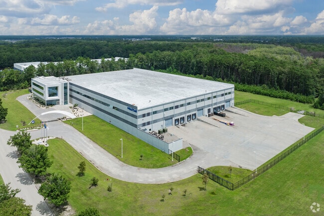

Property Detail
1328 Garrott Ave
211-00-02-085
ASSESSMENT DISTRICT: 369MT HOLLY COMMERCE PARKPARCEL 3A
Distributionwarehouseregional
Berkeley
BERKELEY C
South Carolina
AE The base floodplain where base flood elevations are provided. AE Zones are now used on new format FIRMs instead of A1-A30 Zones.
21.93 AC
2025
Outlying Berkeley County
2025
Charleston/N Charleston
020707
Charleston-North Charleston, SC
113,661 SF
NEARBY LISTINGS FOR SALE OR LEASE
-
-
View all Moncks Corner listings for sale on LoopNet.com
DEMOGRAPHICS near 1328 Garrott Ave
1 mile
3 mile
5 mile
2025 Total Population
2,305
16,532
73,465
2030 Population
2,604
18,721
82,818
Pop Growth 2025-2030
+ 12.97%
+ 13.24%
+ 12.73%
Average Age
34
36
38
2025 Total Households
778
5,722
27,054
HH Growth 2025-2030
+ 13.50%
+ 13.74%
+ 13.18%
Median Household Inc
$97,964
$101,143
$86,899
Avg Household Size
2.90
2.90
2.70
2025 Avg HH Vehicles
2.00
2.00
2.00
Median Home Value
$352,363
$367,386
$332,453
Median Year Built
2010
2010
2005
Nearby Places
Map Layers
Map Styles
 Street
 Aerial
Layers
 Traffic
 Biking
Places
Listings with unknown addresses are not visible on the map
- Restaurants
- Banks
- Shops
- Fitness
- Groceries
PUBLIC TRANSPORTATION
AIRPORT
Charleston AFB/International
Drive
Walk
Distance
Charleston AFB/International
29 min
16.8 mi
Freight Ports
North Charleston Terminal
Drive
Walk
Distance
North Charleston Terminal
22 min
15.2 mi
Nearby Properties
Address
Land Use
TOTAL SIZE
Lot Size
Zoning
Address
Land Use
TOTAL SIZE
Lot Size
Zoning
2,600 SF
26.39 AC
MONCKS COR
Address
Land Use
TOTAL SIZE
Lot Size
Zoning
55,363 SF
9.13 AC
MONCKS COR
Address
Land Use
TOTAL SIZE
Lot Size
Zoning
264,200 SF
47.96 AC
BERKELEY C
Address
Land Use
TOTAL SIZE
Lot Size
Zoning
236,940 SF
27.43 AC
BERKELEY C
Address
Land Use
TOTAL SIZE
Lot Size
Zoning
135,200 SF
13.53 AC
BERKELEY C
Address
Land Use
TOTAL SIZE
Lot Size
Zoning
200,772 SF
30.94 AC
BERKELEY C
Address
Land Use
TOTAL SIZE
Lot Size
Zoning
83,500 SF
6 AC
BERKELEY C
Address
Land Use
TOTAL SIZE
Lot Size
Zoning
16,800 SF
7.77 AC
BERKELEY C
Address
Land Use
TOTAL SIZE
Lot Size
Zoning
54,600 SF
21.23 AC
BERKELEY C
Address
Land Use
TOTAL SIZE
Lot Size
Zoning
2,464.94 AC
BERKELEY C
Address
Land Use
TOTAL SIZE
Lot Size
Zoning
18,200 SF
6 AC
MONCKS COR
Address
Land Use
TOTAL SIZE
Lot Size
Zoning
100,440 SF
15 AC
BERKELEY C
Address
Land Use
TOTAL SIZE
Lot Size
Zoning
40.32 AC
BERKELEY C
Address
Land Use
TOTAL SIZE
Lot Size
Zoning
85,325 SF
28.95 AC
BERKELEY C
Address
Land Use
TOTAL SIZE
Lot Size
Zoning
35.23 AC
BERKELEY C
Address
Land Use
TOTAL SIZE
Lot Size
Zoning
32.84 AC
BERKELEY C
Address
Land Use
TOTAL SIZE
Lot Size
Zoning
20,393 SF
50.95 AC
BERKELEY C
Address
Land Use
TOTAL SIZE
Lot Size
Zoning
12,100 SF
5.26 AC
BERKELEY C
Address
Land Use
TOTAL SIZE
Lot Size
Zoning
45,081 SF
6.97 AC
MONCKS COR
Address
Land Use
TOTAL SIZE
Lot Size
Zoning
24.16 AC
BERKELEY C
Address
Land Use
TOTAL SIZE
Lot Size
Zoning
7,810 SF
1.24 AC
MONCKS COR
Address
Land Use
TOTAL SIZE
Lot Size
Zoning
31,550 SF
22.54 AC
BERKELEY C
Address
Land Use
TOTAL SIZE
Lot Size
Zoning
84.02 AC
MONCKS COR
Address
Land Use
TOTAL SIZE
Lot Size
Zoning
5,096 SF
10.76 AC
BERKELEY C
Address
Land Use
TOTAL SIZE
Lot Size
Zoning
4,329 SF
1.27 AC
MONCKS COR
Address
Land Use
TOTAL SIZE
Lot Size
Zoning
70,000 SF
7.13 AC
BERKELEY C
Address
Land Use
TOTAL SIZE
Lot Size
Zoning
387.64 AC
BERKELEY C
Address
Land Use
TOTAL SIZE
Lot Size
Zoning
13,346 SF
17.03 AC
MONCKS COR
Address
Land Use
TOTAL SIZE
Lot Size
Zoning
103,000 SF
16.07 AC
BERKELEY C
The World's #1 Commercial Real Estate Marketplace
Connect with us
© 2026 CoStar Group
The information above has been obtained from sources believed reliable. While we do not doubt its accuracy we have not verified it and make no guarantee, warranty or representation about it. It is your responsibility to independently confirm its accuracy and completeness. Any projections, opinions, assumptions, or estimates used are for example only and do not represent the current or future performance of the property. The value of this transaction to you depends on tax and other factors which should be evaluated by your tax, financial, and legal advisors. You and your advisors should conduct a careful, independent investigation of the property to determine to your satisfaction the suitability of the property for your needs.