Property Record
1328A Avenida High Vw, Driftwood, TX 78619


Save to a Folder
{{folder.Name}}
{{folder.ListingIds.length}} Properties
{{folder.ListingIds.length}} Property
Create a New Folder
Property Detail
1328A Avenida High Vw
Austin-Round Rock-San Marcos, TX
HIGH VIEW RANCH, BLOCK A, LOT PT 2, ACRES 49.21 (1.21 AC @ MKT FOR IMPS)
R110607
HAYS
Pasture
Texas
B and X Area of moderate flood hazard, usually the area between the limits of the 100-year and 500-year floods.
2
2025
49.21 AC
2025
Hays County
010812
Austin
5,409 SF
NEARBY LISTINGS FOR SALE OR LEASE
DEMOGRAPHICS near 1328A Avenida High Vw
1 mile
3 mile
5 mile
2025 Total Population
109
1,976
10,824
2030 Population
127
2,303
12,577
Pop Growth 2025-2030
+ 16.51%
+ 16.55%
+ 16.20%
Average Age
46
47
46
2025 Total Households
42
771
4,543
HH Growth 2025-2030
+ 19.05%
+ 17.64%
+ 17.30%
Median Household Inc
$122,499
$152,623
$98,470
Avg Household Size
2.40
2.50
2.40
2025 Avg HH Vehicles
2.00
2.00
2.00
Median Home Value
$823,529
$805,722
$528,839
Median Year Built
2002
2005
2003
Nearby Places
Map Layers
Map Styles
 Street
 Aerial
Layers
 Traffic
 Biking
Places
Listings with unknown addresses are not visible on the map
- Restaurants
- Banks
- Shops
- Fitness
- Groceries
PUBLIC TRANSPORTATION
AIRPORT
Austin-Bergstrom International
Drive
Walk
Distance
Austin-Bergstrom International
65 min
38.3 mi
Freight Ports
Calhoun Port
Drive
Walk
Distance
Calhoun Port
204 min
157.4 mi
Nearby Properties
Address
Land Use
TOTAL SIZE
Lot Size
Zoning
Address
Land Use
TOTAL SIZE
Lot Size
Zoning
1,776 SF
11.62 AC
Address
Land Use
TOTAL SIZE
Lot Size
Zoning
7,282 SF
15.87 AC
Address
Land Use
TOTAL SIZE
Lot Size
Zoning
800 SF
7.22 AC
Address
Land Use
TOTAL SIZE
Lot Size
Zoning
12,780 SF
83.76 AC
Address
Land Use
TOTAL SIZE
Lot Size
Zoning
8,763 SF
21 AC
Address
Land Use
TOTAL SIZE
Lot Size
Zoning
2,199 SF
45.01 AC
Address
Land Use
TOTAL SIZE
Lot Size
Zoning
8,887 SF
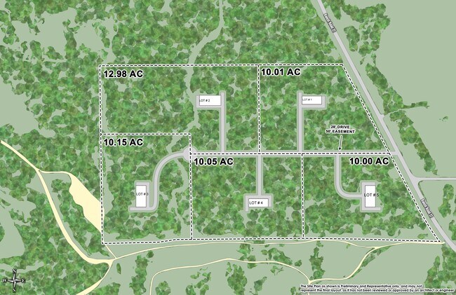
10.01 AC
Address
Land Use
TOTAL SIZE
Lot Size
Zoning
6,514 SF
17.97 AC
Address
Land Use
TOTAL SIZE
Lot Size
Zoning
11,897 SF
3.31 AC
Address
Land Use
TOTAL SIZE
Lot Size
Zoning
30,290 SF
6.15 AC
Address
Land Use
TOTAL SIZE
Lot Size
Zoning
6,805 SF
32.66 AC
Address
Land Use
TOTAL SIZE
Lot Size
Zoning
4,732 SF
25.01 AC
Address
Land Use
TOTAL SIZE
Lot Size
Zoning
8,127 SF
25 AC
Address
Land Use
TOTAL SIZE
Lot Size
Zoning
Address
Land Use
TOTAL SIZE
Lot Size
Zoning
5,513 SF
13.39 AC
Address
Land Use
TOTAL SIZE
Lot Size
Zoning
2,254 SF
14.89 AC
Address
Land Use
TOTAL SIZE
Lot Size
Zoning
9,534 SF
25 AC
Address
Land Use
TOTAL SIZE
Lot Size
Zoning
3,809 SF
1.84 AC
Address
Land Use
TOTAL SIZE
Lot Size
Zoning
5,620 SF
175.22 AC
Address
Land Use
TOTAL SIZE
Lot Size
Zoning
Address
Land Use
TOTAL SIZE
Lot Size
Zoning
2,224 SF
24.06 AC
Address
Land Use
TOTAL SIZE
Lot Size
Zoning
25.23 AC
Address
Land Use
TOTAL SIZE
Lot Size
Zoning
3,906 SF
13.64 AC
Address
Land Use
TOTAL SIZE
Lot Size
Zoning
Address
Land Use
TOTAL SIZE
Lot Size
Zoning
2,042 SF
4.10 AC
Address
Land Use
TOTAL SIZE
Lot Size
Zoning
1,820 SF
13.29 AC
Address
Land Use
TOTAL SIZE
Lot Size
Zoning
5,157 SF
14.67 AC
Address
Land Use
TOTAL SIZE
Lot Size
Zoning
3,472 SF
21.33 AC
Address
Land Use
TOTAL SIZE
Lot Size
Zoning
The World's #1 Commercial Real Estate Marketplace
Connect with us
© 2026 CoStar Group
The information above has been obtained from sources believed reliable. While we do not doubt its accuracy we have not verified it and make no guarantee, warranty or representation about it. It is your responsibility to independently confirm its accuracy and completeness. Any projections, opinions, assumptions, or estimates used are for example only and do not represent the current or future performance of the property. The value of this transaction to you depends on tax and other factors which should be evaluated by your tax, financial, and legal advisors. You and your advisors should conduct a careful, independent investigation of the property to determine to your satisfaction the suitability of the property for your needs.