Property Record
1329 N Us Highway 287, Fort Collins, CO 80524
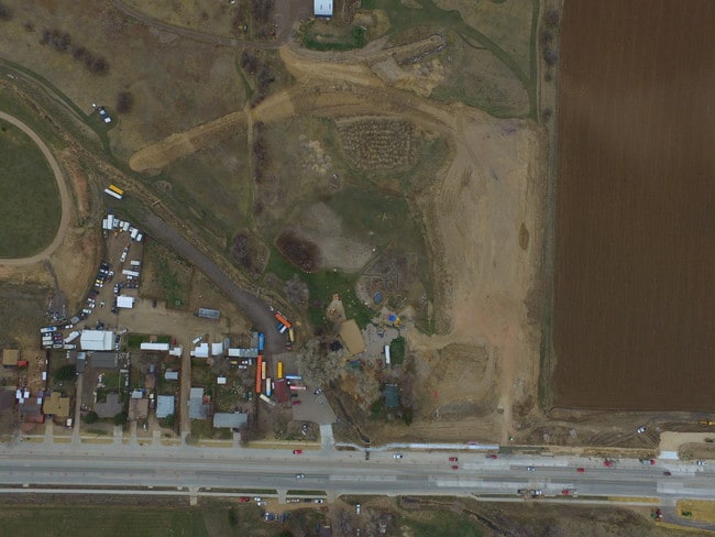

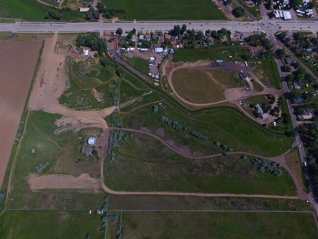
Property Detail
1329 N Us Highway 287
Fort Collins-Loveland, CO
LOT 1, TAMLIN MLD 2ND AND TRACT A, KANE EXEMPTION AMND FIL NO 14-S3228 (20150002273)
98341-10-701
Larimer
Recreationalentertainmentgeneral
Colorado
B and X Area of moderate flood hazard, usually the area between the limits of the 100-year and 500-year floods.
1
2024
12.88 AC
2025
Fort Collins/Loveland
001301
Denver
1,920 SF
NEARBY LISTINGS FOR SALE OR LEASE
DEMOGRAPHICS near 1329 N Us Highway 287
1 mile
3 mile
5 mile
2025 Total Population
737
26,176
95,698
2030 Population
736
26,986
99,477
Pop Growth 2025-2030
(0.14%)
+ 3.09%
+ 3.95%
Average Age
41
41
35
2025 Total Households
283
11,195
38,149
HH Growth 2025-2030
(0.35%)
+ 3.20%
+ 4.53%
Median Household Inc
$77,564
$78,309
$65,365
Avg Household Size
2.50
2.30
2.20
2025 Avg HH Vehicles
2.00
2.00
2.00
Median Home Value
$419,231
$634,824
$595,575
Median Year Built
1976
1977
1985
Nearby Places
Map Layers
Map Styles
 Street
 Aerial
Transit
 Traffic
 Biking
Places
Listings with unknown addresses are not visible on the map
- Restaurants
- Banks
- Shops
- Fitness
- Groceries
Nearby Properties
Address
Land Use
TOTAL SIZE
Lot Size
Zoning
Address
Land Use
TOTAL SIZE
Lot Size
Zoning
397,677 SF
28.87 AC
FA
Address
Land Use
TOTAL SIZE
Lot Size
Zoning
172,211 SF
1.92 AC
D
Address
Land Use
TOTAL SIZE
Lot Size
Zoning
155,149 SF
3.67 AC
D
Address
Land Use
TOTAL SIZE
Lot Size
Zoning
191,673 SF
17.39 AC
I
Address
Land Use
TOTAL SIZE
Lot Size
Zoning
400,000 SF
1.31 AC
D
Address
Land Use
TOTAL SIZE
Lot Size
Zoning
87,563 SF
3.15 AC
Address
Land Use
TOTAL SIZE
Lot Size
Zoning
110,700 SF
44.74 AC
FA
Address
Land Use
TOTAL SIZE
Lot Size
Zoning
107,170 SF
14.61 AC
Address
Land Use
TOTAL SIZE
Lot Size
Zoning
116,589 SF
0.87 AC
Address
Land Use
TOTAL SIZE
Lot Size
Zoning
112,289 SF
10.33 AC
CCN
Address
Land Use
TOTAL SIZE
Lot Size
Zoning
111,960 SF
16.50 AC
O
Address
Land Use
TOTAL SIZE
Lot Size
Zoning
47,421 SF
6.40 AC
POL
Address
Land Use
TOTAL SIZE
Lot Size
Zoning
148,194 SF
2.04 AC
Address
Land Use
TOTAL SIZE
Lot Size
Zoning
86,564 SF
5.19 AC
D
Address
Land Use
TOTAL SIZE
Lot Size
Zoning
243,786 SF
14.65 AC
LMN
Address
Land Use
TOTAL SIZE
Lot Size
Zoning
48,826 SF
8.29 AC
POL
Address
Land Use
TOTAL SIZE
Lot Size
Zoning
225,160 SF
5.64 AC
Address
Land Use
TOTAL SIZE
Lot Size
Zoning
35,415 SF
0.45 AC
Address
Land Use
TOTAL SIZE
Lot Size
Zoning
64,500 SF
7.20 AC
UE
Address
Land Use
TOTAL SIZE
Lot Size
Zoning
72,500 SF
18.54 AC
E
Address
Land Use
TOTAL SIZE
Lot Size
Zoning
46,566 SF
0.33 AC
D
Address
Land Use
TOTAL SIZE
Lot Size
Zoning
3,444 SF
40.32 AC
POL
Address
Land Use
TOTAL SIZE
Lot Size
Zoning
115,713 SF
0.68 AC
Address
Land Use
TOTAL SIZE
Lot Size
Zoning
25,319 SF
0.60 AC
Address
Land Use
TOTAL SIZE
Lot Size
Zoning
49,953 SF
0.97 AC
Address
Land Use
TOTAL SIZE
Lot Size
Zoning
41,652 SF
1.18 AC
Address
Land Use
TOTAL SIZE
Lot Size
Zoning
29,936 SF
0.13 AC
Address
Land Use
TOTAL SIZE
Lot Size
Zoning
43,689 SF
0.87 AC
NCB
Address
Land Use
TOTAL SIZE
Lot Size
Zoning
31,724 SF
0.81 AC
D
Address
Land Use
TOTAL SIZE
Lot Size
Zoning
58,900 SF
7.88 AC
NCL
The World's #1 Commercial Real Estate Marketplace
Connect with us
© 2026 CoStar Group
The information above has been obtained from sources believed reliable. While we do not doubt its accuracy we have not verified it and make no guarantee, warranty or representation about it. It is your responsibility to independently confirm its accuracy and completeness. Any projections, opinions, assumptions, or estimates used are for example only and do not represent the current or future performance of the property. The value of this transaction to you depends on tax and other factors which should be evaluated by your tax, financial, and legal advisors. You and your advisors should conduct a careful, independent investigation of the property to determine to your satisfaction the suitability of the property for your needs.