Property Record
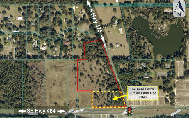
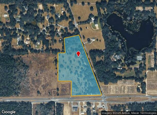
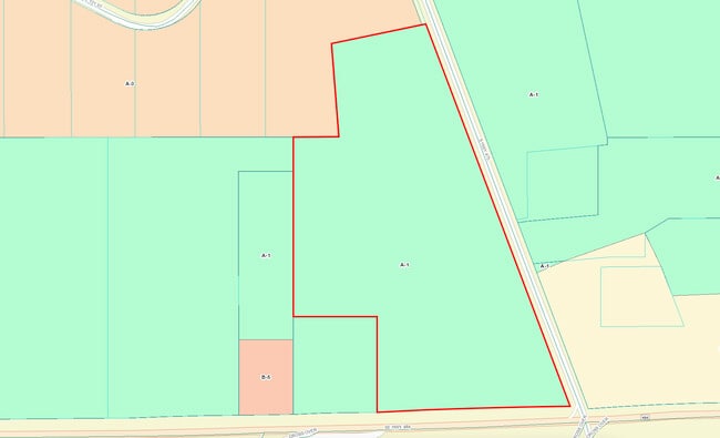
13390 S Highway 475, Ocala, FL 34480
This Property Is For Sale
NEARBY LISTINGS FOR SALE OR LEASE
Property Detail
13390 S Highway 475
41482-000-00
SEC 08 TWP 17 RGE 22 SE 1/4 OF NE 1/4 W OF SR 475 & COM AT NE COR OF SEC 8 TH W ALONG N BNDY TO THE W ROW LINE OF SR 475 TH S 20-29-00 E 910.14 FT TO THE POB TH S 78-18-10 W 405.81 FT TH S 04-25-50 E 392.49 FT TH N 89-58-10 E TO THE WLY ROW LINE TH N
Agriculturalland
Marion
X
Florida
12083C0740D
128
2024
26.68 AC
2024
Outlying Marion County
000901
Ocala
682 SF
Ocala, FL
DEMOGRAPHICS near 13390 S Highway 475
1 Mile
3 Mile
5 Mile
2024 Total Population
333
8,278
43,849
2029 Population
374
9,363
49,967
Pop Growth 2024-2029
+ 12.31%
+ 13.11%
+ 13.95%
Average Age
43
44
42
2024 Total Households
131
3,304
16,703
HH Growth 2024-2029
+ 11.45%
+ 12.83%
+ 13.67%
Median Household Inc
$103,125
$78,800
$63,270
Avg Household Size
2.40
2.40
2.60
2024 Avg HH Vehicles
2.00
2.00
2.00
Median Home Value
$292,856
$193,625
$195,042
Median Year Built
1996
2000
1998
Nearby Places
- Restaurants
- Banks
- Shops
- Fitness
- Groceries
Nearby Properties
Address
Land Use
TOTAL SIZE
Lot Size
Zoning
Address
Land Use
TOTAL SIZE
Lot Size
Zoning
64.26 AC
PUD
Address
Land Use
TOTAL SIZE
Lot Size
Zoning
80,705 SF
63.12 AC
PUD
Address
Land Use
TOTAL SIZE
Lot Size
Zoning
8,243 SF
33.70 AC
PRV
Address
Land Use
TOTAL SIZE
Lot Size
Zoning
16,191 SF
2.84 AC
B4
Address
Land Use
TOTAL SIZE
Lot Size
Zoning
12,994 SF
1.98 AC
B2
Address
Land Use
TOTAL SIZE
Lot Size
Zoning
67,524 SF
12.52 AC
B5
Address
Land Use
TOTAL SIZE
Lot Size
Zoning
3,436 SF
301.77 AC
A1
Address
Land Use
TOTAL SIZE
Lot Size
Zoning
501 SF
520 AC
A1
Address
Land Use
TOTAL SIZE
Lot Size
Zoning
18,907 SF
86.86 AC
A1
Address
Land Use
TOTAL SIZE
Lot Size
Zoning
61,453 SF
18.94 AC
B4
Address
Land Use
TOTAL SIZE
Lot Size
Zoning
9,580 SF
1.45 AC
B2
Address
Land Use
TOTAL SIZE
Lot Size
Zoning
1,960 SF
250 AC
A1
Address
Land Use
TOTAL SIZE
Lot Size
Zoning
15,289 SF
9.73 AC
A1
Address
Land Use
TOTAL SIZE
Lot Size
Zoning
1,104 SF
47.36 AC
PUD
Address
Land Use
TOTAL SIZE
Lot Size
Zoning
8,194 SF
10.98 AC
A1
Address
Land Use
TOTAL SIZE
Lot Size
Zoning
8,395 SF
6.56 AC
B4
Address
Land Use
TOTAL SIZE
Lot Size
Zoning
12,889 SF
19.19 AC
RC1
Address
Land Use
TOTAL SIZE
Lot Size
Zoning
36,450 SF
3 AC
B5
Address
Land Use
TOTAL SIZE
Lot Size
Zoning
12,219 SF
356.48 AC
A1
Address
Land Use
TOTAL SIZE
Lot Size
Zoning
7,182 SF
10.37 AC
A1
Address
Land Use
TOTAL SIZE
Lot Size
Zoning
188.23 AC
A1
Address
Land Use
TOTAL SIZE
Lot Size
Zoning
10,179 SF
2.89 AC
B2
Address
Land Use
TOTAL SIZE
Lot Size
Zoning
21,708 SF
2.76 AC
B2
Address
Land Use
TOTAL SIZE
Lot Size
Zoning
7,321 SF
273.43 AC
A1
Address
Land Use
TOTAL SIZE
Lot Size
Zoning
4,695 SF
72.37 AC
A1
Address
Land Use
TOTAL SIZE
Lot Size
Zoning
135 AC
A1
Address
Land Use
TOTAL SIZE
Lot Size
Zoning
4,172 SF
220 AC
A1
Address
Land Use
TOTAL SIZE
Lot Size
Zoning
4,192 SF
117.51 AC
A1
Address
Land Use
TOTAL SIZE
Lot Size
Zoning
6,186 SF
1.67 AC
B2
Address
Land Use
TOTAL SIZE
Lot Size
Zoning
6,349 SF
11.26 AC
A1
The World's #1 Commercial Real Estate Marketplace
Connect with us
© 2025 CoStar Group
The information above has been obtained from sources believed reliable. While we do not doubt its accuracy we have not verified it and make no guarantee, warranty or representation about it. It is your responsibility to independently confirm its accuracy and completeness. Any projections, opinions, assumptions, or estimates used are for example only and do not represent the current or future performance of the property. The value of this transaction to you depends on tax and other factors which should be evaluated by your tax, financial, and legal advisors. You and your advisors should conduct a careful, independent investigation of the property to determine to your satisfaction the suitability of the property for your needs.