Property Record
133 Bernal Rd, San Jose, CA 95119
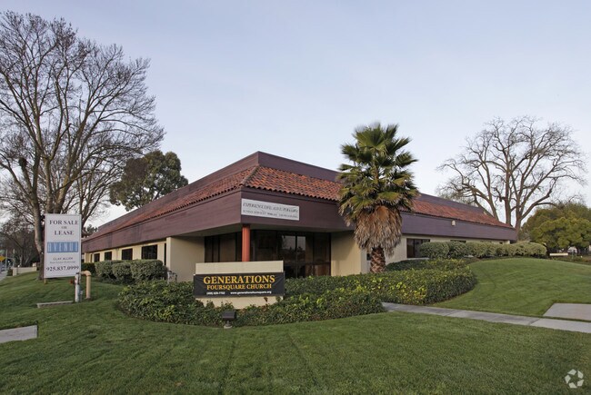

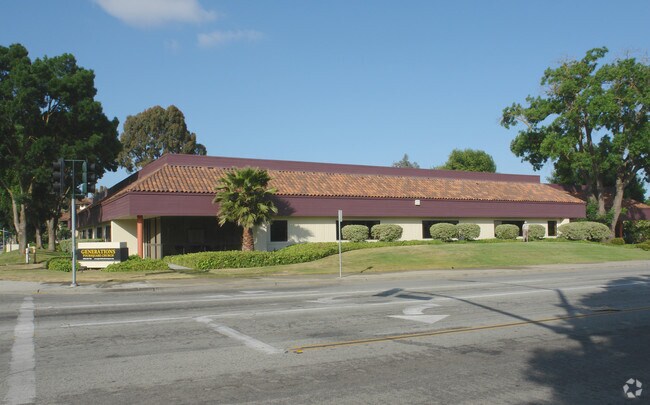

Property Detail
133 Bernal Rd
Financialbuilding
Santa Clara
IP
California
D Areas with possible but undetermined flood hazards.
1.59 AC
2024
South San Jose
2025
South Bay/San Jose
512032
San Jose-Sunnyvale-Santa Clara, CA
22,560 SF
706-01-063
NEARBY LISTINGS FOR SALE OR LEASE
DEMOGRAPHICS near 133 Bernal Rd
1 mile
3 mile
5 mile
2025 Total Population
14,760
68,931
186,334
2030 Population
15,107
70,262
189,510
Pop Growth 2025-2030
+ 2.35%
+ 1.93%
+ 1.70%
Average Age
41
39
41
2025 Total Households
4,734
22,108
59,240
HH Growth 2025-2030
+ 2.34%
+ 1.89%
+ 1.71%
Median Household Inc
$157,203
$141,788
$150,646
Avg Household Size
3.00
3.00
3.00
2025 Avg HH Vehicles
2.00
2.00
2.00
Median Home Value
$1,059,465
$1,078,049
$1,083,966
Median Year Built
1976
1978
1977
Nearby Places
Map Layers
Map Styles
 Street
 Aerial
Layers
 Traffic
 Biking
Places
Listings with unknown addresses are not visible on the map
- Restaurants
- Banks
- Shops
- Fitness
- Groceries
PUBLIC TRANSPORTATION
COMMUTER RAIL
Drive
Walk
Distance
10 min
2.4 mi
Drive
Walk
Distance
12 min
6.3 mi
AIRPORT
Norman Y Mineta San Jose International
Drive
Walk
Distance
Norman Y Mineta San Jose International
22 min
15.8 mi
Freight Ports
Port of Redwood City
Drive
Walk
Distance
Port of Redwood City
43 min
33.9 mi
Nearby Properties
Address
Land Use
TOTAL SIZE
Lot Size
Zoning
Address
Land Use
TOTAL SIZE
Lot Size
Zoning
160,002 SF
7.54 AC
IP
Address
Land Use
TOTAL SIZE
Lot Size
Zoning
715,000 SF
10.81 AC
PUD
Address
Land Use
TOTAL SIZE
Lot Size
Zoning
350,451 SF
4.69 AC
M1PD
Address
Land Use
TOTAL SIZE
Lot Size
Zoning
11.14 AC
A(PD)
Address
Land Use
TOTAL SIZE
Lot Size
Zoning
620,000 SF
200.12 AC
A--PD
Address
Land Use
TOTAL SIZE
Lot Size
Zoning
95,483 SF
176.29 AC
IP(PD
Address
Land Use
TOTAL SIZE
Lot Size
Zoning
286,330 SF
17.38 AC
IP
Address
Land Use
TOTAL SIZE
Lot Size
Zoning
7.36 AC
IP
Address
Land Use
TOTAL SIZE
Lot Size
Zoning
10.56 AC
APD
Address
Land Use
TOTAL SIZE
Lot Size
Zoning
541,667 SF
509.96 AC
APD
Address
Land Use
TOTAL SIZE
Lot Size
Zoning
283,959 SF
8.34 AC
IP
Address
Land Use
TOTAL SIZE
Lot Size
Zoning
11.39 AC
A-PD
Address
Land Use
TOTAL SIZE
Lot Size
Zoning
310,788 SF
5.85 AC
PD
Address
Land Use
TOTAL SIZE
Lot Size
Zoning
188,064 SF
25.33 AC
IP
Address
Land Use
TOTAL SIZE
Lot Size
Zoning
6.79 AC
A-PD
Address
Land Use
TOTAL SIZE
Lot Size
Zoning
275,000 SF
12.24 AC
A-PD
Address
Land Use
TOTAL SIZE
Lot Size
Zoning
95,846 SF
5.82 AC
A(PD)
Address
Land Use
TOTAL SIZE
Lot Size
Zoning
10.07 AC
PD
Address
Land Use
TOTAL SIZE
Lot Size
Zoning
60,000 SF
10.51 AC
IP
Address
Land Use
TOTAL SIZE
Lot Size
Zoning
185,600 SF
11.33 AC
IP
Address
Land Use
TOTAL SIZE
Lot Size
Zoning
5,976 SF
7.43 AC
MIPD
Address
Land Use
TOTAL SIZE
Lot Size
Zoning
209,101 SF
3.52 AC
APD
Address
Land Use
TOTAL SIZE
Lot Size
Zoning
217,548 SF
3.42 AC
PD
Address
Land Use
TOTAL SIZE
Lot Size
Zoning
126,569 SF
5.74 AC
SJ
Address
Land Use
TOTAL SIZE
Lot Size
Zoning
131,500 SF
20.54 AC
IPC
Address
Land Use
TOTAL SIZE
Lot Size
Zoning
203,783 SF
11.90 AC
IPB
Address
Land Use
TOTAL SIZE
Lot Size
Zoning
59,316 SF
6.21 AC
IP
Address
Land Use
TOTAL SIZE
Lot Size
Zoning
187,110 SF
2.11 AC
I
Address
Land Use
TOTAL SIZE
Lot Size
Zoning
9.17 AC
M1PD
Address
Land Use
TOTAL SIZE
Lot Size
Zoning
162,066 SF
10.60 AC
IP
The World's #1 Commercial Real Estate Marketplace
Connect with us
© 2026 CoStar Group
The information above has been obtained from sources believed reliable. While we do not doubt its accuracy we have not verified it and make no guarantee, warranty or representation about it. It is your responsibility to independently confirm its accuracy and completeness. Any projections, opinions, assumptions, or estimates used are for example only and do not represent the current or future performance of the property. The value of this transaction to you depends on tax and other factors which should be evaluated by your tax, financial, and legal advisors. You and your advisors should conduct a careful, independent investigation of the property to determine to your satisfaction the suitability of the property for your needs.