Property Record
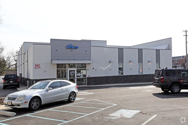
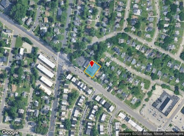
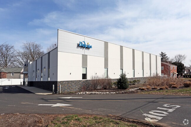
133 Cheltenham Ave, Cheltenham, PA 19012

NEARBY LISTINGS FOR SALE OR LEASE
Property Detail
133 Cheltenham Ave
31-00-05368-001
ASSESSOR BLOCK-UNIT NUMBER 87D-23
Medicalbuilding
Montgomery
X
Pennsylvania
42091C0411G
23
2024
0.35 AC
2025
Horsham/Willow Grove
202202
Philadelphia
8,454 SF
Philadelphia-Camden-Wilmington, PA-NJ-DE-MD
DEMOGRAPHICS near 133 Cheltenham Ave
1 Mile
3 Mile
5 Mile
2024 Total Population
31,592
324,661
791,358
2029 Population
30,716
313,213
766,707
Pop Growth 2024-2029
(2.77%)
(3.53%)
(3.12%)
Average Age
40
39
39
2024 Total Households
11,596
121,208
301,484
HH Growth 2024-2029
(3.09%)
(3.55%)
(3.22%)
Median Household Inc
$67,554
$50,447
$49,636
Avg Household Size
2.60
2.60
2.50
2024 Avg HH Vehicles
1.00
1.00
1.00
Median Home Value
$190,971
$175,704
$195,733
Median Year Built
1951
1949
1949
Nearby Places
Map Layers
Map Styles
 Street
 Aerial
- Restaurants
- Banks
- Shops
- Fitness
- Groceries
PUBLIC TRANSPORTATION
TRANSIT/SUBWAY
Melrose Park (R1 - Southeastern Pennsylvania Transportation Authority Regional Rail (SEPTA Regional Rail), R2 - Southeastern Pennsylvania Transportation Authority Regional Rail (SEPTA Regional Rail), R3 - Southeastern Pennsylvania Transportation Authority Regional Rail (SEPTA Regional Rail), R5 - Southeastern Pennsylvania Transportation Authority Regional Rail (SEPTA Regional Rail))
DRIVE
WALK
Distance
Melrose Park (R1 - Southeastern Pennsylvania Transportation Authority Regional Rail (SEPTA Regional Rail), R2 - Southeastern Pennsylvania Transportation Authority Regional Rail (SEPTA Regional Rail), R3 - Southeastern Pennsylvania Transportation Authority Regional Rail (SEPTA Regional Rail), R5 - Southeastern Pennsylvania Transportation Authority Regional Rail (SEPTA Regional Rail))
2 min
17 min
0.9 mi
COMMUTER RAIL
Melrose Park (R1 - Southeastern Pennsylvania Transportation Authority Regional Rail (SEPTA Regional Rail), R2 - Southeastern Pennsylvania Transportation Authority Regional Rail (SEPTA Regional Rail), R3 - Southeastern Pennsylvania Transportation Authority Regional Rail (SEPTA Regional Rail), R5 - Southeastern Pennsylvania Transportation Authority Regional Rail (SEPTA Regional Rail))
DRIVE
WALK
Distance
Melrose Park (R1 - Southeastern Pennsylvania Transportation Authority Regional Rail (SEPTA Regional Rail), R2 - Southeastern Pennsylvania Transportation Authority Regional Rail (SEPTA Regional Rail), R3 - Southeastern Pennsylvania Transportation Authority Regional Rail (SEPTA Regional Rail), R5 - Southeastern Pennsylvania Transportation Authority Regional Rail (SEPTA Regional Rail))
3 min
17 min
0.7 mi
Olney (R8 - Southeastern Pennsylvania Transportation Authority Regional Rail (SEPTA Regional Rail))
DRIVE
WALK
Distance
Olney (R8 - Southeastern Pennsylvania Transportation Authority Regional Rail (SEPTA Regional Rail))
4 min
1.5 mi
AIRPORT
Philadelphia International
DRIVE
WALK
Distance
Philadelphia International
34 min
20.5 mi
Trenton Mercer
DRIVE
WALK
Distance
Trenton Mercer
45 min
27.0 mi
Freight Ports
Port of Philadelphia
DRIVE
WALK
Distance
Port of Philadelphia
11 min
6.3 mi
Nearby Properties
Address
Land Use
TOTAL SIZE
Lot Size
Zoning
Address
Land Use
TOTAL SIZE
Lot Size
Zoning
2,146,150 SF
119.95 AC
M1
Address
Land Use
TOTAL SIZE
Lot Size
Zoning
3,590 SF
50 AC
SPPOA
Address
Land Use
TOTAL SIZE
Lot Size
Zoning
287,286 SF
1.26 AC
CMX5
Address
Land Use
TOTAL SIZE
Lot Size
Zoning
290,454 SF
58.56 AC
RSA1
Address
Land Use
TOTAL SIZE
Lot Size
Zoning
17,886 SF
80 AC
SPPOA
Address
Land Use
TOTAL SIZE
Lot Size
Zoning
107,391 SF
13.68 AC
SPINS
Address
Land Use
TOTAL SIZE
Lot Size
Zoning
425,128 SF
23 AC
RSA5
Address
Land Use
TOTAL SIZE
Lot Size
Zoning
504,972 SF
16.30 AC
RM2
Address
Land Use
TOTAL SIZE
Lot Size
Zoning
314,694 SF
96.36 AC
RSA3
Address
Land Use
TOTAL SIZE
Lot Size
Zoning
238,378 SF
18 AC
CA1
Address
Land Use
TOTAL SIZE
Lot Size
Zoning
2,500,000 SF
134.14 AC
I2
Address
Land Use
TOTAL SIZE
Lot Size
Zoning
75,358 SF
24.98 AC
I2
Address
Land Use
TOTAL SIZE
Lot Size
Zoning
1,316,610 SF
46.73 AC
I2
Address
Land Use
TOTAL SIZE
Lot Size
Zoning
208,620 SF
19.71 AC
I2
Address
Land Use
TOTAL SIZE
Lot Size
Zoning
210,964 SF
21.28 AC
CMX3
Address
Land Use
TOTAL SIZE
Lot Size
Zoning
526,165 SF
12.68 AC
RSA3
Address
Land Use
TOTAL SIZE
Lot Size
Zoning
28,239 SF
1.48 AC
SPINS
Address
Land Use
TOTAL SIZE
Lot Size
Zoning
16,832 SF
65.87 AC
SPPOA
Address
Land Use
TOTAL SIZE
Lot Size
Zoning
363,136 SF
16.47 AC
RSA3
Address
Land Use
TOTAL SIZE
Lot Size
Zoning
233,143 SF
24.24 AC
SPINS
Address
Land Use
TOTAL SIZE
Lot Size
Zoning
329,300 SF
6.98 AC
RSA5
Address
Land Use
TOTAL SIZE
Lot Size
Zoning
281,012 SF
32.58 AC
RSA5
Address
Land Use
TOTAL SIZE
Lot Size
Zoning
217,800 SF
0.31 AC
ICMX
Address
Land Use
TOTAL SIZE
Lot Size
Zoning
3,104 SF
0.09 AC
RSA2
Address
Land Use
TOTAL SIZE
Lot Size
Zoning
116,124 SF
7.70 AC
CMX3
Address
Land Use
TOTAL SIZE
Lot Size
Zoning
171,000 SF
23 AC
RM1
Address
Land Use
TOTAL SIZE
Lot Size
Zoning
103,131 SF
0.19 AC
CMX3
Address
Land Use
TOTAL SIZE
Lot Size
Zoning
243,889 SF
20.89 AC
CA2
Address
Land Use
TOTAL SIZE
Lot Size
Zoning
146,924 SF
6.61 AC
RSA5
Address
Land Use
TOTAL SIZE
Lot Size
Zoning
180,066 SF
59.77 AC
RSA3
The World's #1 Commercial Real Estate Marketplace
Connect with us
© 2025 CoStar Group
The information above has been obtained from sources believed reliable. While we do not doubt its accuracy we have not verified it and make no guarantee, warranty or representation about it. It is your responsibility to independently confirm its accuracy and completeness. Any projections, opinions, assumptions, or estimates used are for example only and do not represent the current or future performance of the property. The value of this transaction to you depends on tax and other factors which should be evaluated by your tax, financial, and legal advisors. You and your advisors should conduct a careful, independent investigation of the property to determine to your satisfaction the suitability of the property for your needs.