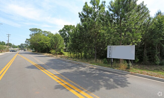
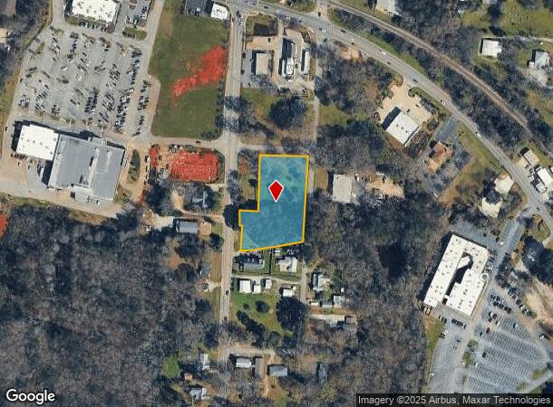
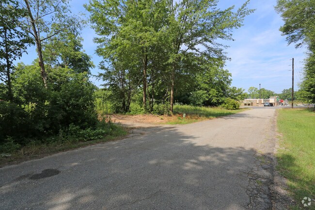
Property Record
133 Clark St, Chapin, SC 29036
NEARBY LISTINGS FOR SALE OR LEASE
Property Detail
133 Clark St
000717-03-002
Lexington
Commercialacreage
South Carolina
X
1.45 AC
45063C0040J
Dutch Fork/Irmo
2025
Columbia
2024
Columbia, SC
021204
DEMOGRAPHICS near 133 Clark St
1 mile
3 mile
5 mile
2024 Total Population
1,957
8,648
23,625
2029 Population
2,137
9,403
25,377
Pop Growth 2024-2029
+ 9.20%
+ 8.73%
+ 7.42%
Average Age
39
40
42
2024 Total Households
742
3,241
8,952
HH Growth 2024-2029
+ 9.30%
+ 8.82%
+ 7.57%
Median Household Inc
$70,075
$70,990
$92,209
Avg Household Size
2.60
2.60
2.60
2024 Avg HH Vehicles
2.00
2.00
2.00
Median Home Value
$217,696
$245,779
$302,635
Median Year Built
2002
1999
1999
Nearby Places
Map Layers
Map Styles
 Street
 Aerial
Transit
 Traffic
 Biking
Places
Listings with unknown addresses are not visible on the map
- Restaurants
- Banks
- Shops
- Fitness
- Groceries
PUBLIC TRANSPORTATION
AIRPORT
Columbia Metro
Drive
Walk
Distance
Columbia Metro
44 min
28.2 mi
SALE & LEASE HISTORY
LISTING DATE
SALE/LEASE

Jun 27, 2017
For Sale
Aug 17, 2017
For Sale
Nearby Properties
Address
Land Use
TOTAL SIZE
Lot Size
Zoning
Address
Land Use
TOTAL SIZE
Lot Size
Zoning
Address
Land Use
TOTAL SIZE
Lot Size
Zoning
87.84 AC
Address
Land Use
TOTAL SIZE
Lot Size
Zoning
4,824 SF
4.28 AC
RU
Address
Land Use
TOTAL SIZE
Lot Size
Zoning
46,031 SF
12.16 AC
GC
Address
Land Use
TOTAL SIZE
Lot Size
Zoning
2,402 SF
6.53 AC
RU
Address
Land Use
TOTAL SIZE
Lot Size
Zoning
88 AC
RU
Address
Land Use
TOTAL SIZE
Lot Size
Zoning
3,163 SF
2 AC
RU
Address
Land Use
TOTAL SIZE
Lot Size
Zoning
6,368 SF
12 AC
RU
Address
Land Use
TOTAL SIZE
Lot Size
Zoning
2,402 SF
4.30 AC
RU
Address
Land Use
TOTAL SIZE
Lot Size
Zoning
67.59 AC
RU
Address
Land Use
TOTAL SIZE
Lot Size
Zoning
2,806 SF
6.10 AC
RU
Address
Land Use
TOTAL SIZE
Lot Size
Zoning
960 SF
45 AC
RU
Address
Land Use
TOTAL SIZE
Lot Size
Zoning
4,181 SF
11.12 AC
RU
Address
Land Use
TOTAL SIZE
Lot Size
Zoning
6,358 SF
17.11 AC
RU
Address
Land Use
TOTAL SIZE
Lot Size
Zoning
2,694 SF
8 AC
RU
Address
Land Use
TOTAL SIZE
Lot Size
Zoning
3,446 SF
7.66 AC
RU
Address
Land Use
TOTAL SIZE
Lot Size
Zoning
5,451 SF
3.99 AC
RU
Address
Land Use
TOTAL SIZE
Lot Size
Zoning
3,873 SF
9.27 AC
RU
Address
Land Use
TOTAL SIZE
Lot Size
Zoning
2,705 SF
5.01 AC
RU
Address
Land Use
TOTAL SIZE
Lot Size
Zoning
2,988 SF
5.70 AC
RU
Address
Land Use
TOTAL SIZE
Lot Size
Zoning
5,360 SF
3.49 AC
RU
Address
Land Use
TOTAL SIZE
Lot Size
Zoning
3,457 SF
5.69 AC
RU
Address
Land Use
TOTAL SIZE
Lot Size
Zoning
3,975 SF
5 AC
RU
Address
Land Use
TOTAL SIZE
Lot Size
Zoning
3,142 SF
5.02 AC
RU
Address
Land Use
TOTAL SIZE
Lot Size
Zoning
3,405 SF
5.07 AC
RU
Address
Land Use
TOTAL SIZE
Lot Size
Zoning
2,638 SF
0.19 AC
PDD
Address
Land Use
TOTAL SIZE
Lot Size
Zoning
3,080 SF
3.14 AC
RU
Address
Land Use
TOTAL SIZE
Lot Size
Zoning
3,710 SF
2.11 AC
RU
Address
Land Use
TOTAL SIZE
Lot Size
Zoning
3,493 SF
3.08 AC
RU
Address
Land Use
TOTAL SIZE
Lot Size
Zoning
61,972 SF
7.82 AC
GC
The World's #1 Commercial Real Estate Marketplace
Connect with us
© 2026 CoStar Group
The information above has been obtained from sources believed reliable. While we do not doubt its accuracy we have not verified it and make no guarantee, warranty or representation about it. It is your responsibility to independently confirm its accuracy and completeness. Any projections, opinions, assumptions, or estimates used are for example only and do not represent the current or future performance of the property. The value of this transaction to you depends on tax and other factors which should be evaluated by your tax, financial, and legal advisors. You and your advisors should conduct a careful, independent investigation of the property to determine to your satisfaction the suitability of the property for your needs.