Property Record
133 Kempsville Rd, Chesapeake, VA 23320
NEARBY LISTINGS FOR SALE OR LEASE
Property Detail
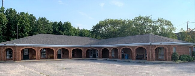
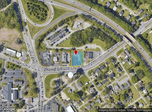
133 Kempsville Rd
0482001000600
Kempsville Road Corridor
Officebuilding
PT OAK GROVE .962AC
X
Chesapeake
5100340038D
Virginia
2024
0.96 AC
2025
Southern Chesapeake
020805
Hampton Roads
6,504 SF
Virginia Beach-Norfolk-Newport News, VA-NC
DEMOGRAPHICS near 133 Kempsville Rd
1 Mile
3 Mile
5 Mile
2024 Total Population
7,113
69,883
159,494
2029 Population
7,331
71,924
163,856
Pop Growth 2024-2029
+ 3.06%
+ 2.92%
+ 2.73%
Average Age
42
40
39
2024 Total Households
3,171
27,101
59,572
HH Growth 2024-2029
+ 3.28%
+ 3.05%
+ 2.84%
Median Household Inc
$77,717
$95,318
$95,926
Avg Household Size
2.20
2.50
2.60
2024 Avg HH Vehicles
2.00
2.00
2.00
Median Home Value
$348,259
$354,149
$338,709
Median Year Built
1995
1991
1990
Nearby Places
Map Layers
Map Styles
 Street
 Aerial
- Restaurants
- Banks
- Shops
- Fitness
- Groceries
PUBLIC TRANSPORTATION
COMMUTER RAIL
DRIVE
WALK
Distance
14 min
9.8 mi
AIRPORT
Norfolk International
DRIVE
WALK
Distance
Norfolk International
24 min
14.6 mi
Newport News/Williamsburg International
DRIVE
WALK
Distance
Newport News/Williamsburg International
58 min
37.9 mi
Freight Ports
Virginia Port Authority - Portsmouth
DRIVE
WALK
Distance
Virginia Port Authority - Portsmouth
23 min
13.7 mi
SALE & LEASE HISTORY
LISTING DATE
SALE/LEASE

Aug 11, 2021
For Sale
Nearby Properties
Address
Land Use
TOTAL SIZE
Lot Size
Zoning
Address
Land Use
TOTAL SIZE
Lot Size
Zoning
470,098 SF
14.10 AC
O-I: OFFIC
Address
Land Use
TOTAL SIZE
Lot Size
Zoning
405,992 SF
40.22 AC
PUD: PLANN
Address
Land Use
TOTAL SIZE
Lot Size
Zoning
6,820 SF
89.90 AC
R15S: RESI
Address
Land Use
TOTAL SIZE
Lot Size
Zoning
141,461 SF
169.22 AC
C1: CONSER
Address
Land Use
TOTAL SIZE
Lot Size
Zoning
299,727 SF
170.79 AC
C1: CONSER
Address
Land Use
TOTAL SIZE
Lot Size
Zoning
154,540 SF
1.68 AC
O-I: OFFIC
Address
Land Use
TOTAL SIZE
Lot Size
Zoning
209,403 SF
2.81 AC
PUD: PLANN
Address
Land Use
TOTAL SIZE
Lot Size
Zoning
95,354 SF
39.53 AC
B2: GENERA
Address
Land Use
TOTAL SIZE
Lot Size
Zoning
145,522 SF
15.51 AC
PUD: PLANN
Address
Land Use
TOTAL SIZE
Lot Size
Zoning
286,936 SF
15 AC
RMF1: MULT
Address
Land Use
TOTAL SIZE
Lot Size
Zoning
168,391 SF
28.39 AC
B2: GENERA
Address
Land Use
TOTAL SIZE
Lot Size
Zoning
218,812 SF
45.15 AC
PUD: PLANN
Address
Land Use
TOTAL SIZE
Lot Size
Zoning
140,369 SF
10.35 AC
PUD: PLANN
Address
Land Use
TOTAL SIZE
Lot Size
Zoning
26.63 AC
Address
Land Use
TOTAL SIZE
Lot Size
Zoning
92,723 SF
28.83 AC
R6: RESIDE
Address
Land Use
TOTAL SIZE
Lot Size
Zoning
270,962 SF
6.17 AC
MXD-U: MIX
Address
Land Use
TOTAL SIZE
Lot Size
Zoning
277,846 SF
12.50 AC
RMF1: MULT
Address
Land Use
TOTAL SIZE
Lot Size
Zoning
75,936 SF
11.13 AC
MULTI: MUL
Address
Land Use
TOTAL SIZE
Lot Size
Zoning
127,755 SF
14.68 AC
PUD: PLANN
Address
Land Use
TOTAL SIZE
Lot Size
Zoning
188,683 SF
13.14 AC
O-I: OFFIC
Address
Land Use
TOTAL SIZE
Lot Size
Zoning
162,291 SF
2.98 AC
PUD: PLANN
Address
Land Use
TOTAL SIZE
Lot Size
Zoning
256,041 SF
12.32 AC
RMF1: MULT
Address
Land Use
TOTAL SIZE
Lot Size
Zoning
166,753 SF
1.46 AC
PUD: PLANN
Address
Land Use
TOTAL SIZE
Lot Size
Zoning
422.43 AC
PUD: PLANN
Address
Land Use
TOTAL SIZE
Lot Size
Zoning
196,905 SF
46.84 AC
R15S: RESI
Address
Land Use
TOTAL SIZE
Lot Size
Zoning
67,508 SF
16.63 AC
O-I: OFFIC
Address
Land Use
TOTAL SIZE
Lot Size
Zoning
19,962 SF
52.38 AC
PUD: PLANN
Address
Land Use
TOTAL SIZE
Lot Size
Zoning
119,946 SF
9.76 AC
M2: GENERA
Address
Land Use
TOTAL SIZE
Lot Size
Zoning
135,504 SF
10.07 AC
PUD: PLANN
Address
Land Use
TOTAL SIZE
Lot Size
Zoning
152,650 SF
5.53 AC
O-I: OFFIC
The World's #1 Commercial Real Estate Marketplace
Connect with us
© 2025 CoStar Group
The information above has been obtained from sources believed reliable. While we do not doubt its accuracy we have not verified it and make no guarantee, warranty or representation about it. It is your responsibility to independently confirm its accuracy and completeness. Any projections, opinions, assumptions, or estimates used are for example only and do not represent the current or future performance of the property. The value of this transaction to you depends on tax and other factors which should be evaluated by your tax, financial, and legal advisors. You and your advisors should conduct a careful, independent investigation of the property to determine to your satisfaction the suitability of the property for your needs.